hiker crosses snow near summit of Koscielec (2155m), Tatra mountains, Poland

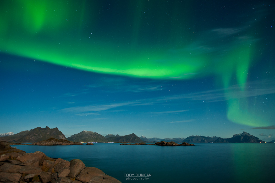
Poland – Tatra Mountains – Part 2

hiker crosses snow near summit of Koscielec (2155m), Tatra mountains, Poland

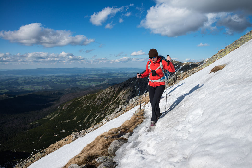
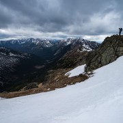
Photo: Nearing the summit of Koscielec, Tatra Mountains, Poland.  May 2014

Perhaps there had been too many beers Friday night in Zakopane, so it was a slow start to get moving on Saturday morning.  Eventually the four of us were loaded into the car and on the way to the trailhead for the Five Lakes Valley in the Polish Tatra mountains.

Some roadworks led to some detours which extended the drive time.  But at some point we decided to call the hut to make sure there was room.  It was May, early in the season and a questionable weather forecast, but better to be safe.  At some point in the last year or so, rules changed in some of the huts: from – always having space, even if you sleep in the dining room, to – hut is full, you need to have a room.

Pulling off the road in one of the few places with phone reception, we finally contacted the hut. Full.  Shit!  Next try was to Morskie Oko hut.  Also Full.  Double shit!  There went those plans.

Having a map with me, I suggested we try Murowaniec hut, located on the ‘front’ side of the mountains, a few hours hike above Zakopane.  Luckily there were beds available.  And so a couple hours after we left Zakopane, we were driving back into the town to begin our hike.

The suspect weather had cleared into a nice sunny day by the time we finally got onto the trail, well, more of a fairly well worn path through the forest – the Tatra are a popular hiking destination.  Sometime afternoon we finally arrived at Murowaniec hut to a scene I am familiar with from hiking the Alps, benches of people sitting in the sun eating home cooked food with a glass of beer or two.  The food did smell good, and we were hungry, so after checking into our room for the night, we were ready to get something to eat.

Never having been to this part of the mountains, I wasn’t really sure what to do with the remainder of the day.  I had been up on Kasprovy Wierch, so wasn’t really interested in hiking up there again, and it looked really crowded up on the ridge anyhow.  There was still a lot of snow in all the gullies, so without winter gear we had a fairly limited list of possibilities.  I pointed out an interesting looking peak above the hut, but it turned out not to have a trail to the summit, so a fairly difficult bushwhack through the dense dwarf pines would have been required.  FInally, Jack pointed towards a tall, and from our angle, quite steep looking mountain, the 2155 meter high peak of Koscielec.

Still with a few spiderwebs of snow covering the face, it seemed like the best option, or at least we would go as far as we could.  Backpacks bag on – overnight stuff – we hit the trail in mid afternoon.

While I appreciate the wilderness we have in the mountains of California, sometime I like being able to hike, for the sake of hiking.  This is the experience in the Polish Tatra mountains.  Criss crossed with a seeming endless series of sign posted trails, all are well build and maintained, something like mountain sidewalks.

After an hour or so of hiking we reached a small pass at the base of the mountain.  The angle didn’t look too bad anymore, but I could tell we’d have a few sections of snow to negotiate.

The next hour was spent going up, up, and a bit more up, as the trail wound its way higher on the mountain.   For the most part the route was simple going, with maybe a short scramble here and there.  And of course, ever improving views as we came closer to the summit.  It had been t-shirt weather thus far, but the winds picked up as we neared the summit so it was back into a fleece again, which was good, as I was probably getting pretty sunburnt anyhow!

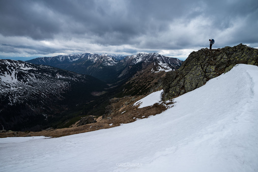
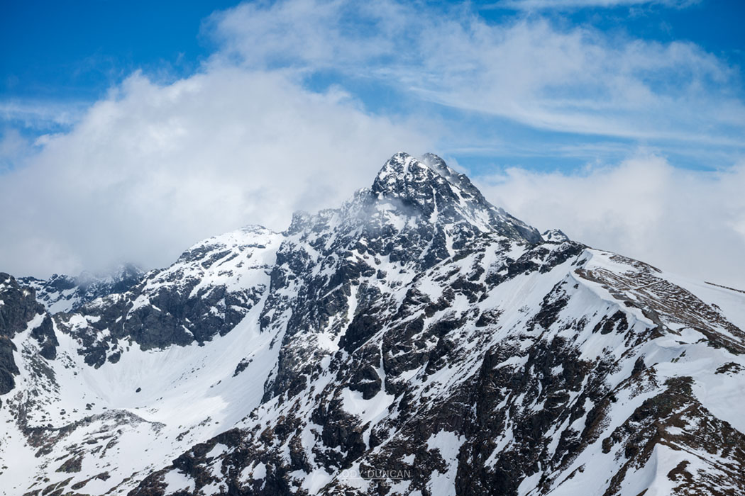
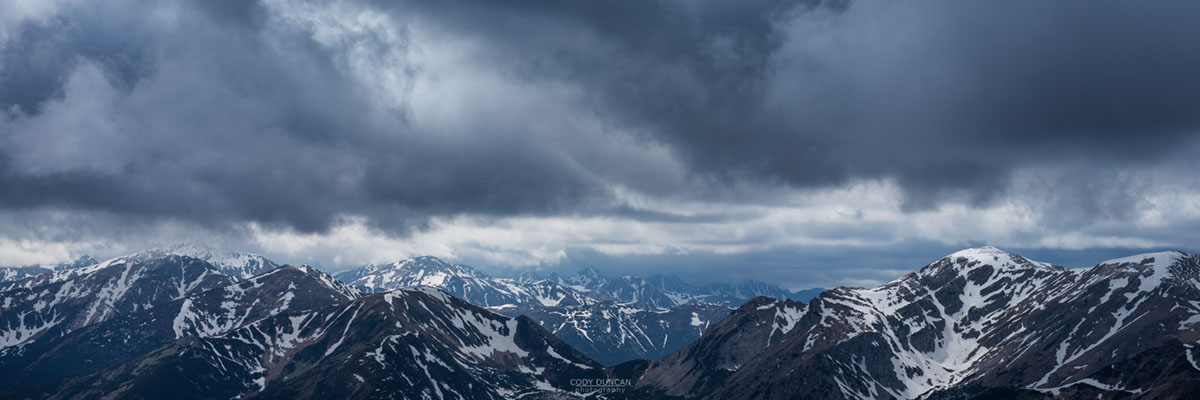
About five o’clock, with the sinking afternoon sun we arrived at the summit.  Wonderful views in every direction, but especially towards the 2301 meter peak of Swinica, still covered with a healthy layer of snow.

We took our time on the summit as the weather was near perfect before we eventually figured it was time to head back down.  Before leaving the hut, we noticed a sign saying, ‘kitchen closes at 21:30.’  Without further inquiry, we figured this would be the last time to order dinner.  A dinner I was greatly looking forward to from my memories of my last trip to the Tatra!

Descent was a little more complicated than the ascent and took a little more time than I thought.  The sky was growing dark as we arrived back at the hut a little before nine o’clock.  I was somewhat shocked to see a full on party going on in the dining hall, even with a live band.

Now looking forward to a good meal, we went up to order, only to be informed that there was only one selection of soup available – a sauerkraut soup that I don’t care for very much.  When asking about the 21:30 closing time, we were informed that was when the whole dining hall closed.  Shit!  10 hours hiking in the mountains and I couldn’t even get dinner.  I guess malted barley water would have to suffice, along with the remainder of my hiking food.

Luckily the presence of the live band meant the dining room stayed open later, so we could at least enjoy a few drinks, somewhat to the protest of the hut warden, who could have been doing good business with the full house crowd, but chose to close the bar, only returning sporadically and serving drinks when sufficiently harassed by enough people shaking money at her.

Sometime after 11pm my head finally hit the pillow.  Jack and I had discussed some place of getting up for sunrise, maybe even hiking up Kasprovy Wierch, we would see.  But by the early morning hours the hut began to creek and the windows bang in the increasing winds.  With barely a hint of morning light I got up to checkout the sky.  Fully grey, and the trees were doing quite a dance.  At that, I was content to stay in my sleeping bag for a while!

A lazy hike out of the mountains and back to Zakopane followed.  We headed to a place to grab lunch (another pizza for me) and as we headed inside, thunder began to rumble and rain fall.  Good timing getting down the mountain I guess.

We got dropped of by Jack in Krakow, where I then ended up on a standing room only mini-bus, I was one of the ones standing, back to Katowice before a tram back to Chorzow.

Overall, not the trip planned, but a good one none the less.  Zakopane is such a wonderful mountain town, and in the spring it is nice and green yet the streets, while still crowded, are not overly crowded.  I wished I had had a few more days just to hang out there and enjoy a bit of mountain town life.  Maybe next time…

Two female hikers hiking in Tatra mountains, Poland

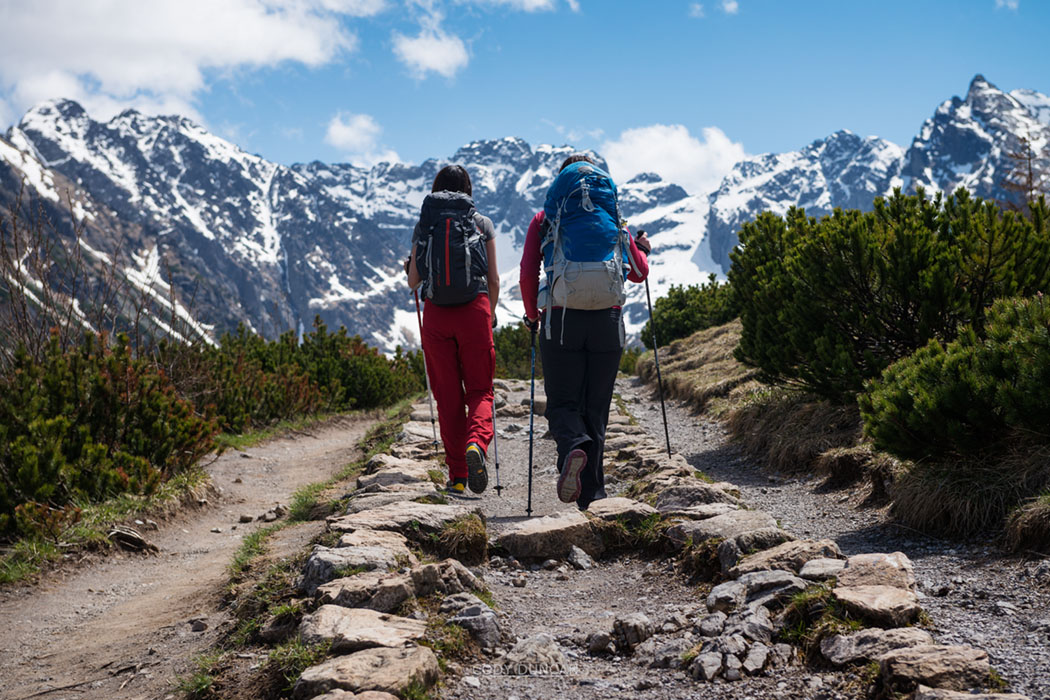
Photo: Heading up the trail to Murowaniec hut, Tatra Mountains, Poland.  May 2014


Female hiker sleeps on bench outside Murowaniec hut, Tatra mountains, Poland

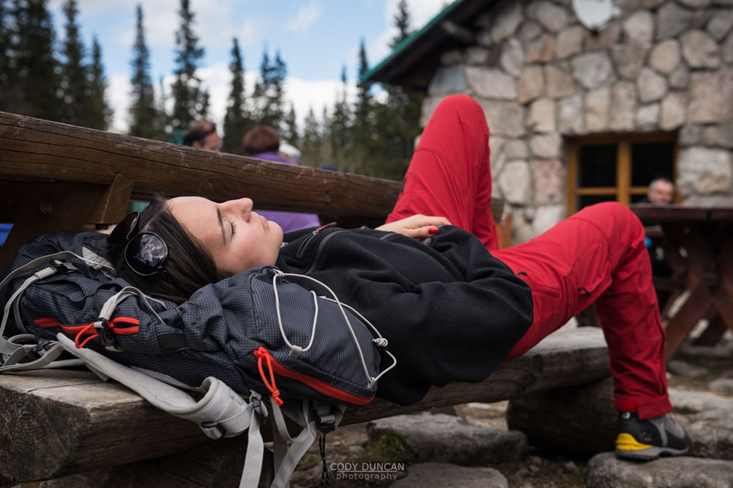
Photo: Afternoon nap outside Murowaniec hut, Tatra Mountains, Poland.  May 2014


Two female hikers hiking in Tatra mountains, Poland

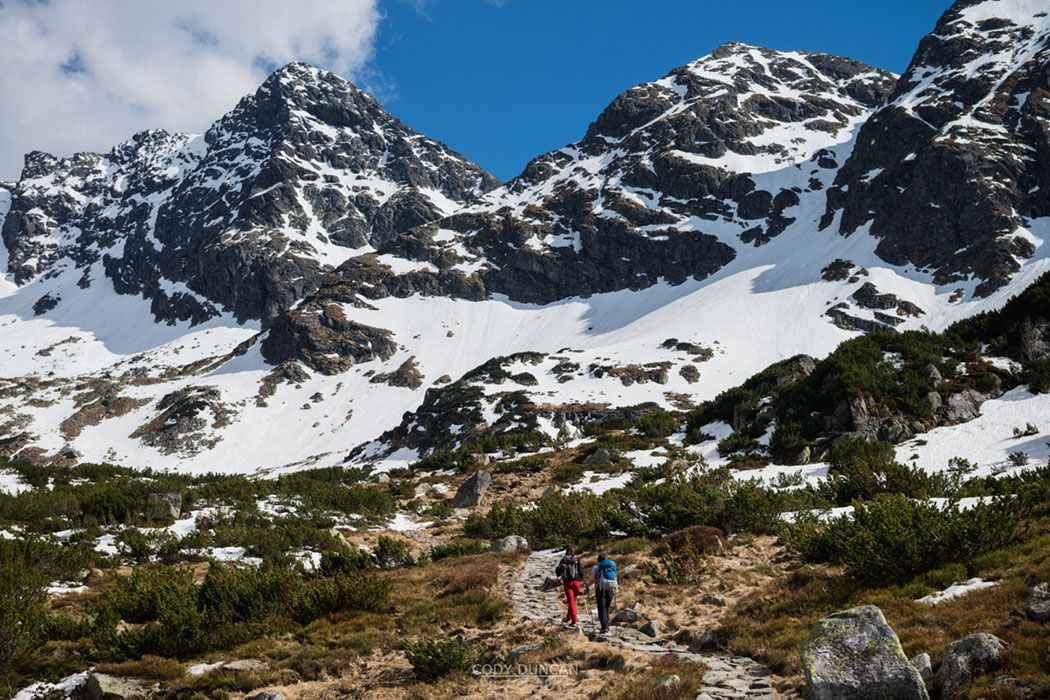
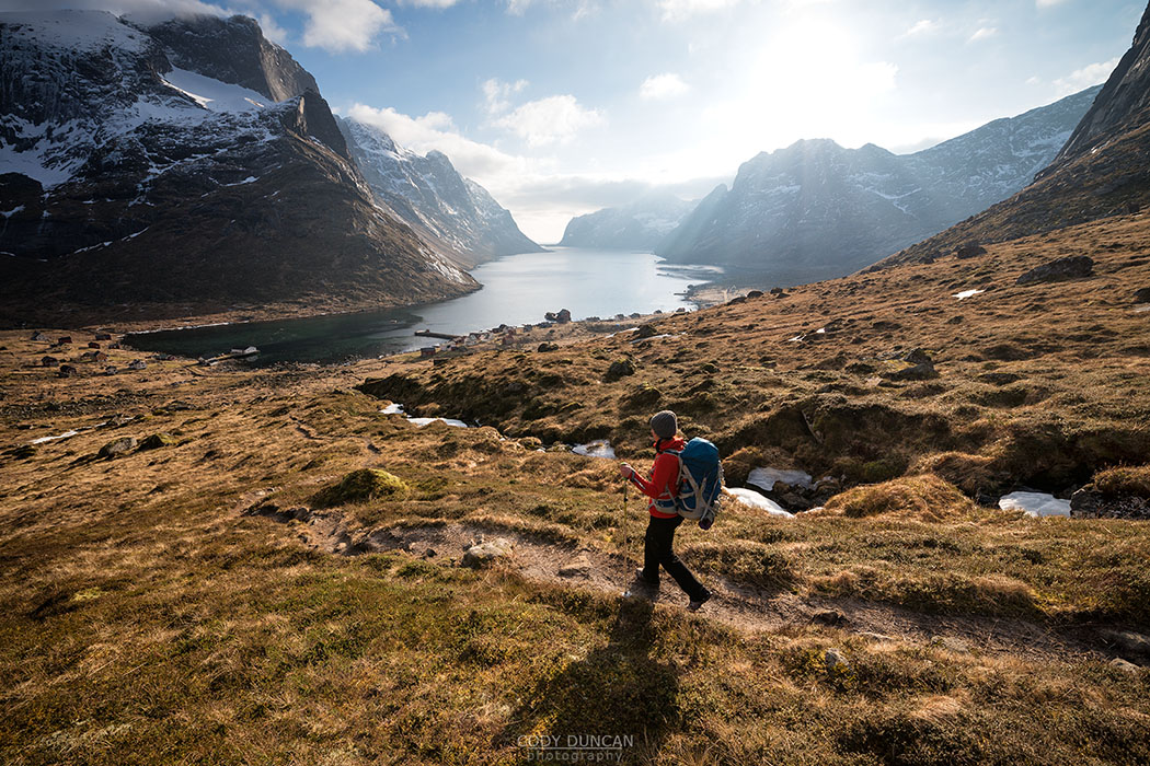
Photo: Hiking towards Koscielec, Tatra Mountains, Poland.  May 2014


Koscielec (2155m) mountain peak, Tatra mountains, Poland

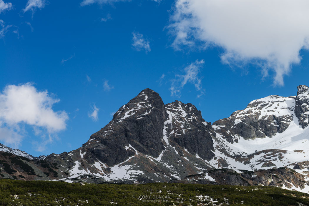
Photo: The 2155 meter high Koscielec rises in the distance, Tatra Mountains, Poland.  may 2014


Female hiker on the summit of Koscielec (2155m), Tatra mountains, Poland

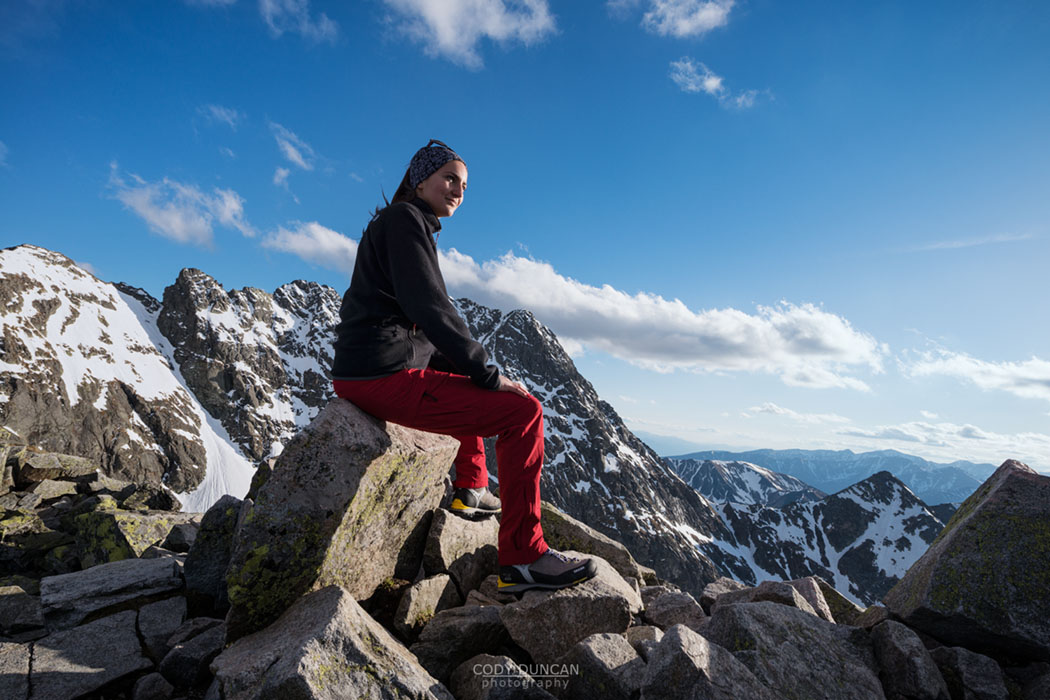
Photo: On the summit of Koscielec, Tatra mountains, Poland.  May 2014


View towards Swinica (2301 m) from summit of Koscielec (2155m), Tatra mountains, Poland

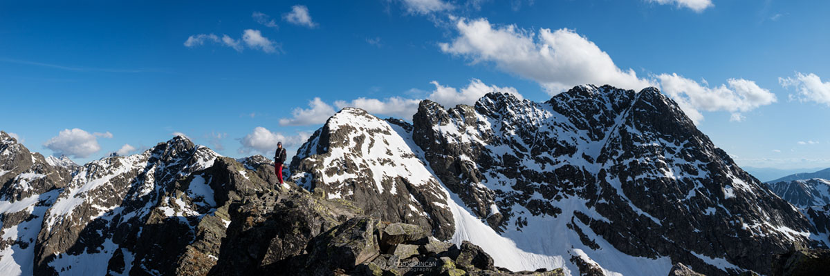
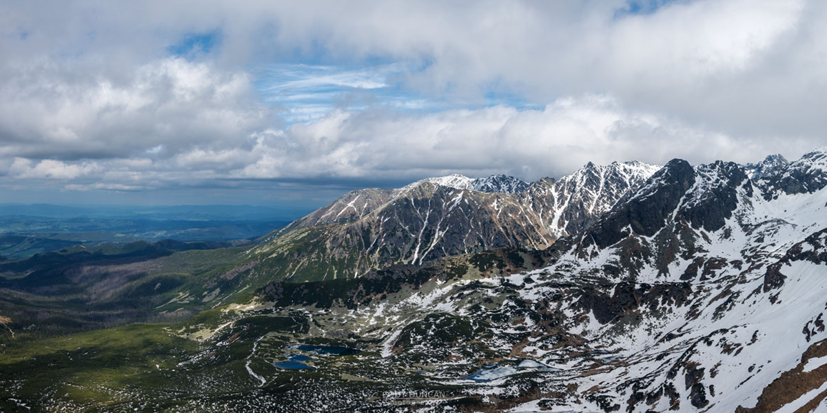
Photo: Panoramic view from the summit of Koscielec, Tatra Mountains, Poland.  May 2014


Murowaniec Mountain hut, Tatra mountains, Poland

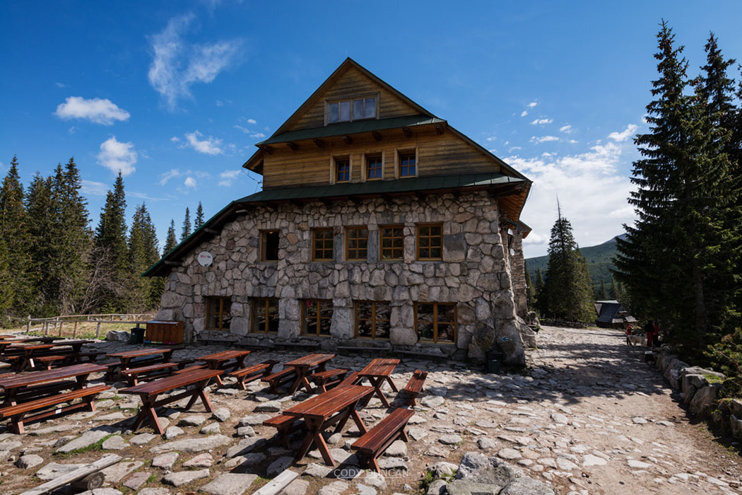
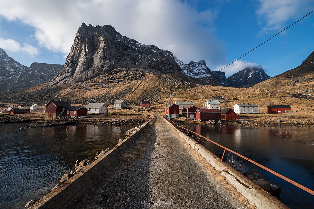
Photo: Murowaniec hut, Tatra Mountains, Poland.  May 2014


Two female hikers sit outside mountain barn, Tatra mountains, Poland

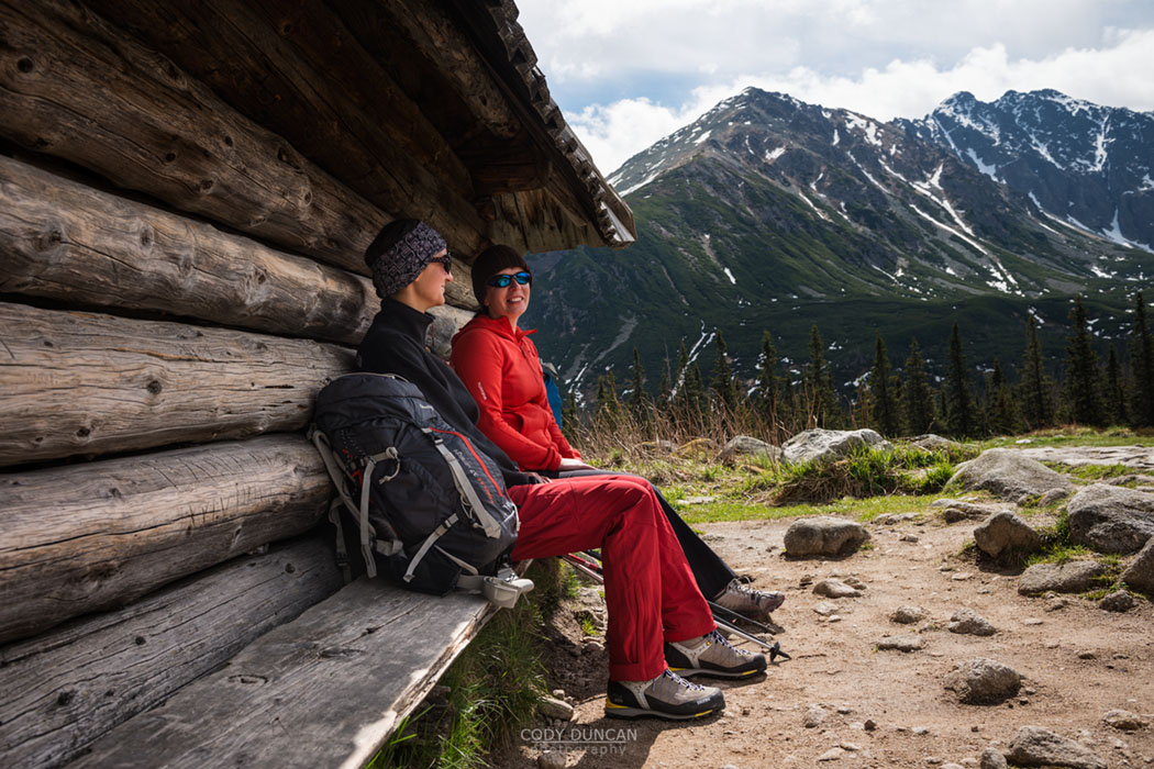
Photo: Resting outside a mountain cabin, Tatra Mountains, Poland.  May 2014

Female hiker near Kasprovy Wierch (1987m), Tatra mountains, Poland

Poland – Tatra Mountains – Part 1

Female hiker near Kasprovy Wierch (1987m), Tatra mountains, Poland

Photo: Stormy spring sky over the Polish Tatra mountains, near Kasprovy Wierch, Poland.  May 2014

My first trip to the Polish Tatra mountains was in the late autumn of 2011 when I was making was way south from Estonia, through Latvia and Lithuania, before an epic, 18 hour bus ride to visit my friend Jack in Jaroslaw, located in the south east corner of Poland, more of less closer to Ukraine than anything else.  After a few days in the nearby Bieszczady mountains, we headed west to the high peaks of the Tatra.

Being November, we weren’t sure what to expect, but 2011 happened to be an unusually warm autumn in Europe and so we had snow free travel up to the hut at the Five Lakes Valley (Dolinie Pięciu Stawów) for our first night in the mountains.  The next day we continued on towards Morskie Oko hut, thinking about hiking Poland’s highest mountain, Rysy, before deciding conditions weren’t too good.

While somewhat small compared to the Alps, the Tatra left an impression on me as a wild and rugged set of peaks with some stunning views from the high summits.

Returning to Poland this May, I made plans to meet with Jack in the mountains again.  Staying in Chorzow, near Katowice, it took half a day on Polish busses to arrive in Zakopane, where we would spend Friday night before heading further into the mountains.

The weather forecast was so-so, actually rather poor.  Arriving on Friday afternoon in Zakopane, the skies overhead were heavy and dark.  Being lazy, and with a few hours of daylight left, we took the cable car to the summit of Kasprovy Wierch to at least get a few mountain photos.

The trip was also to do a bit of scouting for the next day’s hike, as one of the possibilities was to cross from Kasprovy Wierch over into FIve Lakes Valley and stay in the hut for the night.  But from up high, it was evident that without winter gear, there was still too much snow up high for the journey to be possible.  So it was back down to Zakopane for a pizza and some beers (and a Kebab on the way back to the guesthouse).

We made plans to head to Five Lakes Valley in the morning.


Sprintime view over Tatra mountains, from near Kasprovy Wierch (1987 m), Poland

Photo: Spring in the Tatra mountains, Poland.  May 2014

View towards Swinica (2301 m) from Beskid (2014 m), Tatra mountains, Poland

Photo: Snow covered Swinica, Tatra mountains, Poland.  May 2014

Stormy weather over Tatra mountains, Poland/Slovakia

Photo: Dark sky over the Slovakian side of the Tatra mountains, near Kasprovy Wierch, Poland.  May 2014

Dramatic coastal mountain landscape viewed from Ryten, Lofoten Islands, Norway

Back On Dry Land – Lofoten

Dramatic coastal mountain landscape viewed from Ryten, Lofoten Islands, Norway

Photo: Summer evening view from the summit of Ryten, Lofoten Islands, Norway.  August 2012

I will be on Lofoten now for more of less the whole of September.  Hopefully the weather is as good as the previous two years, as I have put together a pretty long ‘to-do’ list of mountains to hike.  And I have a few mountains I need to hike again, hopefully with some better weather, to add more hiking guides to this website, as it seems there is some new competition out there these days.

If you see someone (me) in an somewhat ugly bright blue jacket, come and say hello.  Or you can try and contact me via FACEBOOK or INSTAGRAM if you know you’ll be around…

I want to try and remain on Lofoten as long as possible, especially as the chance for northern lights grows with the ever darkening nights of autumn – the best displays always seem to be the day after I leave, so I suggest scheduling at trip for the beginning of October! 🙂

But it will be a long trip down from the north car, and not knowing what the weather may due, I might be forced south a bit earlier than planned.  Plus, this will be my first ever opportunity to visit central Norway by car, and there is a huge list of place I want to see or re-visit from my hitchhiking days of years gone by.

Northern Lights fill sky above mountains of Lofoten Islands, Norway

Lofoten Images in 2015 Geo Saison Calendar

Northern Lights fill sky above mountains of Lofoten Islands, Norway

Photo: Northern Lights over Stamsund, Vestvågøy, Lofoten Islands, Norway.  October 2011

For any of you guys in the German speaking countries, a couple of my Lofoten Islands photos are in the GEO ‘Im Licht des Nordens’ 2015 calendar.

The first image is on the cover, a photo of the northern lights I took in October 2011.  It was my last night of a two week autumn trip to Lofoten.  Thus far, the sky had been quiet, not a hind of northern lights to be found.  Though 2011 was a turbulent autumn, so there often wasn’t much night sky to be seen.  But finally with one night left the weather calmed and the sky remained clear.  I could sense that auroras would appear.  The islands’ final gift to me; making sure I didn’t leave empty handed.  They lights were somewhat late to arrive, but when they did, wow!  I stayed on shore to photograph while Roar took the others out on the boat to gaze at the sky from the calm waters of the Vestfjord.  This was the best aurora I had seen up to that point.

The second image from from the summit of Offersøykammen.  Frustrated with my efforts for the day thus far, I decided just to hike up the small mountain and wait for sunset.  With about 40-50 minutes remaining before sunset, a layer of cloud began to develop over the summit of the mountain.  The cloud thickened, but before I was lost in a total whiteout I was given about 15 minutes of beautiful light.  I never saw the sunset, and as I descended the mountain and could see again I discovered that I hiked up the only mountain covered in cloud.  Though I think it worked out for the best in the end…

So, if you’re in Germany/Austria/Swiss and want to purchase the calendar, you can do so here: Geo – Im Licht des Nordens

geo-saison-2015


Geo Saison calendar 2015


View over Nappstraumen from summit of Offersøykammen, Vestvågøya, Lofoten Islands, Norway

Photo: Autumn light over Offersøykammen, Vestvågøy, Lofoten Islands, Norway.  October 2012

Spring storm over farm field, Opole voivodship, Silesia, Poland

Silesian Fields

Spring storm over farm field, Opole voivodship, Silesia, Poland

Photo: Dark skies over green fields, Opole Voivodship, Upper Silesia, Poland.  May 2014

I stopped along the side of the road in the village of Ligota Bialska (Formerly Ellguth), deep into the southern reaches of the former region of Upper Silesia, to take a quick photo of the WW1 memorial and record the names of the fallen in search of my families distant connections.  From a farm building across the street I hear a shout and then two men begin approaching our rental car.  Though we rented the car in Katowice, the obvious ‘W’ (Warsaw) license plate of the rental agency denoted us as distant foreigners in this quiet, rural part of Poland.

We explained my interest in the memorial.  That I was looking for traces of my family.

‘Hindera? Yes, I think I knew of some Hinderas.  Over in Smicz.’  The old man muttered through his few remaining teeth.

‘Ahh, yes, the name seems familiar.’ His friend interjected.

‘Do you know of still any around?’ We asked.

‘Hmm, no.  It has been a long time.  You’ll probably find them in the cemetery by now…’ The old man replied.

And so we continued on through the Silesian countryside.  The Spring sky dark and heavy with rain.  I was in search of the dead; names now long forgotten.  Upper Silesia is a lonely part of Europe.  Formerly the eastern most expansion of the German Empire and now an empty part of Poland.  Just to the south lies the Czech border, whose mountains rise along the horizon, above fields of barley, wheat, rapeseed, and corn.  The green and yellow fields contrasted with the blue and black sky overhead.  A storm was approaching.

We passed the villages that I have only seen by name in birth, marriage, and death records of my ancestors: Grabina/Grabine, Otoki/Ottok, Ligota Bialska/Ellguth, Biala Prudnicka/Zülz, Wasilowice/Waschelwitz, Smicz/Schmitsch, Wilowice/ Mühlsdorf, Kolnowice/Kohlsdorf.  Tiny, one road towns of crumbling brick buildings and potholed streets.  You’re more likely to see tractors than cars driving along the roads.  The locals watch you out of the corner of their eye, as the rental car was far too nice to be owned by any resident.  What were we doing there?

The addition of the historic German names in 2005 to many of the villages seems to have come at the distain of some locals, and more than once, I noticed the German version of the town name covered in black spay paint.  It appears history still holds bitter memories for some.

We drove further south to Prudnik, now just 5 kilometers north of the Czech border.  After driving in a few circles we next headed west towards Nysa. Just outside of town the sky erupted.  Lightning cracked and thunder rumbled all around us.  I made a quick turn off onto a farmer’s dirt road and into a field where I attempted to photograph the action.  I was just on the edge of the storm but soon that cold breeze picked up and a bolt of lightning hit a little to close for comfort.  Heavy drops of rain began to fall.  I thought of my ancestors, leaving these fields for a new home in Nebraska in the 1880’s and 90’s.  They may have moved a content away, but still they remained in a familiar land.

The storm passed and as we reached Nysa a bit of sun was beginning to shine.  The cities cathedral, beautiful and imposing, rose high above the city center.  But the place overall was a bit too busy for my liking.  And so we took the narrow country roads back north to Opole.  The rain caught up to use once again.  This time without any drama, just grey, liquid skies which lasted into the night.

If it weren’t for an historic family connection, then there is little doubt that I never would have heard of, much less visited, Polish Silesia.  And while you wont ever see any of these town names appearing in guide books or magazine articles, there is still a wealth of history and a lifetime of stories to be discovered in this lonely corner of Europe.  I have little doubt that I’ll be back again.

Abandoned building, Grabine - Grabina, Prudnik County, Opole Voivodship, Silesia, Poland

Photo: Abandoned house in the village of Grabina/Grabine, Opole Voivodship, Upper Silesia, Poland.  May 2014


Abandoned building, Grabine - Grabina, Prudnik County, Opole Voivodship, Silesia, Poland

Photo: Wind and Curtain, Grabina/Grabine, Opole Voivodship, Upper Silesia, Poland.  May 2014


Bales of hay stacked in field, Grabine - Grabina, Prudnik County, Opole Voivodship, Silesia, Poland

Photo: Bales of hay, Grabina/Grabine, Opole Voivodship, Upper Silesia, Poland.  May 2014


Spring thunderstom over Rapeseed field, Prudnik County, Opole Voivodship, Silesia, Poland

Photo: Spring thunderstorm over field, near Laskowiec, Opole Voivodship, Upper Silesia, Poland.  May 2014


Spring thunderstom over fields, Prudnik County, Opole Voivodship, Silesia, Poland

Photo: Approaching storm over field, near Prudnik, Opole Voivodship, Upper Silesia, Poland.  May 2014


Nysa cathedral, Opole Voivodship, Poland

Photo: Nysa Cathedral, Nysa, Opole Voivodship, Upper Silesia, Poland.  May 2014


Old barn in farm field, Prudnik County, Opole Voivodship, Silesia, Poland

Photo: Lone barn in field, Opole Voivodship, Upper Silesia, Poland.  May 2014

Two people enjoy campfire at Bunes Beach, Moskenesoy, Lofoten Islands, Norway

Recent Published Works – Norway and Lofoten

Two people enjoy campfire at Bunes Beach, Moskenesoy, Lofoten Islands, Norway

Photo: Campfire at Bunes beach, Moskenesøy, Lofoten Islands, Norway.  April 2013

Lofoten Islands in National Geographic Traveler Poland – February 2014

A couple of my Lofoten images were published in the February edition of the Polish version of National Geographic Traveler magazine in an article about the world’s most spectacular islands, in which Lofoten rightly was included.

As someone who would loosely be described as a landscape photographer; I would rather be an adventure photographer, but I don’t have enough friends to travel with, so am forced to go alone and merely take landscape photos of my travels – or stay at home, the question is often asked: ‘ Would you like to shoot for National Geographic?’

While the answer is an obvious ‘YES!’  Life is not so simple as based upon the opinions of friends and family.  But now I’m proud to announce I now have some humble beginnings within the famed yellow borders.

Evening twilight over Reine from summit of Reinebringen, Moskenesoy, Lofoten Islands, Norway

Photo: Autumn twilight over Reine from summit of Reinebringen, Moskenesøy, Lofoten Islands, Norway.  September 2013

Lofoten national geographic traveler poland

Photo: Lofoten – National Geographic Traveler (Poland), February 2014

lofoten-nat-geo-traveler-02

Photo: Lofoten – National Geographic Traveler (Poland), February 2014

——-

Hurtigruten and Geirangerfjord, Norway in Men’s Journal – June 2014

One of my Images of the Hurtigruten traveling through the Geirangerfjord in central Norway is in June’s issue of Men’s Journal magazine (US).  I took the image while on a multi-day hitchhiking trip between Bergen and Trondheim (and back) in the summer of 2006 – when I had a lot more free time than money – which is pretty much my same situation today.  I haven’t been to Geirangerfjord since that trip, but my fortune of good timing and weather has made the series of images I took there some of my best selling ones over the last years.

Hurtigruten Norway Mens Journal Magazine

Photo: Hurtigruten and Geirangerfjord, Norway – Men’s Journal Magazine, June 2014

Female hiker takes in view of Llangorse lake from Mynydd Llangorse, Brecon Beacons national park, Wales

Brecon Beacons National Park – Mynydd Llangorse

Female hiker takes in view of Llangorse lake from Mynydd Llangorse, Brecon Beacons national park, Wales

Photo: Watching sunset over Llangorse lake from Mynydd Llangorse, Black Mountains, Brecon Beacons national park, Wales.  April 2014

With the long days of summer just around the corner it’s now possible to head out into the Black Mountains for quick evening hikes from here in Hay-on-Wye.  Normally, the default hike is Twmpa or Hay Bluff, the quickest mountains two reach, just down the road and the very eastern border of Brecon Beacons national park.  With rainy days often spent at the climbing gym at llangorse, I’ve often had my eye of the isolated peaks of Mynydd Troed and Mynydd Llangorse for some time.  And looking for something new to wander around to break out of the normal routine, I finally made the effort to get there.

Arriving at the small parking area between both peaks, I decided to head up the lower Mynydd Llangorse, at 515 meters, as the views towards Llangorse lakes seemed to be more promising.  A short ascent leads to the mountain’s ridge and fantastic views of the gently rolling hills and Hedged-in fields of the Welsh countrside.  In the distant west, the flat, table-like summit of Pen Y Fan rose into the mist.

A strange, soft light covered the last, fading off into the hazy distant mountain peaks.  At times, the sun would break through the clouds, casting beams of light over the land in typical Welsh fashion.  Sunset looked like it would be promising, so I stayed up on the mountain, often surrounded by the wild Welsh mountain ponies, grazing away on the spring grass, until strangely pink sun sunk below the horizon.  Now I’m just waiting for a day with some nice puffy clouds to head back again.

For more images from Mynydd Llangorse, and the rest of the Brecon Beacons national park, you can visit my Welsh image archive: HERE

View towards Llangorse lake from Mynydd Llangorse, Brecon Beacons national park, Wales

Photo: Views over the scenic Welsh countryside, Mynydd Llangorse, Black Mountains, Brecon Beacons national park, Wales.  April 2014

View towards Llangorse lake from Mynydd Llangorse, Brecon Beacons national park, Wales

Photo: Rays of light break through the clouds, Mynydd Llangorse, Black Mountains, Brecon Beacons national park, Wales.  April 2014

Old drystone wall on Mynydd Llangorse, Brecon Beacons national park, Wales

Photo: Old stone wall on Mynydd Llangorse, Black Mountains, Brecon Beacons national park, Wales.  April 2014

Wild Welsh Mountain Pony grazing on hillside of Mynydd Llangorse, Brecon Beacons national park, Wales

Photo: Welsh mountain pony at sunset, Mynydd Llangorse, Black Mountains, Brecon Beacons national park, Wales.  April 2014

Wild Welsh Mountain Pony at sunset on Mynydd Llangorse, Brecon Beacons national park, Wales

Photo: Welsh mountain pony at sunset, Mynydd Llangorse, Black Mountains, Brecon Beacons national park, Wales.  April 2014

Female hill walker hiking on Carmarthen Fans - Bannau Sir Gaer with Picws Du in distance, Black Mountain, Brecon Beacons national park, Wales

Brecon Beacons National Park – Black Mountain

Female hill walker on Carmarthen Fans - Bannau Sir Gaer with Picws Du in distance, Black Mountain, Brecon Beacons national park, Wales

Photo: View along the Carmarthen Fans, Black Mountain, Brecon Beacons national park, Wales.  April 2014

The Black Mountain – Y Mynydd Du, the strangely singularl named mountain range, not to be confused with the Black Mountains or Black Mountain itself, on the Western edge of south Wales’ Brecon Beacons national park is home to the some of the most stunning and wild mountains of the national park.  While the central peaks of the Brecons Beacons can have a near endless train of people heading up on a sunny Sunday afternoon, the Black Mountain receives only a fraction of the foot traffic which is one of the reasons that they are my favourite mountains in the region to hike.

When a fair weathered day presented itself a few weekends back, I headed west to hike one my favourite route: Bannau Sir Gaer – Camarthen Fans.  Often I hike in from the east, as it’s quick to get there, and often just ascend Fan Brycheiniog before returning, but this time I wanted to wait around until sunset, and so decided to hike in from the west via Llyn Y Fan Fach.  From Llyn Y Fan Fach, the trail ascends to Waun Lefrith, with scenic view of the entire Camarthen Fans, before continuing on to the first high point at Picws Du.  From here the trail descends before climbing again to Fan Foel and eventually on to the high point of the range, the 802 meter high Fan Brycheiniog.

Instead of descending the mountains and heading back to the car park, I decided to head back up Picws Du and back along the Camarthen Fan ridge to Waun Lefrith where I was hoping to wait for sunset.  Buts as the afternoon hours passed, heavy clouds began rolling in from the west, and it was evident that any sunset would be unlikely.  So after 7:00pm, as the spring sky was beginning to darken I began to head back down the mountain, slightly hurried by the calling of dinner.

For more images from Black Mountain, and the rest of the Brecon Beacons national park, you can visit my Welsh image archive: HERE

Female hill walker hiking towards Waun Lefrith above Llyn Y Fan Fach, Black Mountain, Brecon Beacons national park, Wales

Photo: Hiking above Llyn Y Fan Fach, Black Mountain, Brecon Beacons national park, Wales.  April 2014

Llyn Y Fan Fach and Carmarthen Fans, Black Mountain, Brecon Beacons national park, Wales

Photo: Llyn Y Fan Fach and Carmarthen Fans, Black Mountain, Brecon Beacons national park, Wales.  April 2014

Female hill walker hiking on Carmarthen Fans - Bannau Sir Gaer with Picws Du in distance, Black Mountain, Brecon Beacons national park, Wales

Photo: View along Carmarthen Fans, Black Mountain, Brecon Beacons national park, Wales.  April 2014

Rock outcropping on ridge of Carmarthen Fans - Bannau Sir Gaer, Black Mountain, Brecon Beacons national park, Wales

Photo: Rock outcropping, Black Mountain, Brecon Beacons national park, Wales.  April 2014

View along Carmarthen Fans - Bannau Sir Gaer towards Picws Du, Black Mountain, Brecon Beacons national park, Wales

Photo: Last light touchest the summit of Fan Foel, Black Mountain, Brecon Beacons national park, Wales

Female hiker leaves footprints in sand on scenic Horseid beach, Moskenesøy, Lofoten Islands, Norway

Lofoten Islands Winter 2014 – Horseid Beach

Female hiker hiking trail towards Horseid beach, Moskenesøy, Lofoten Islands, Norway

Photo: Hiking towards Horseid Beach, Moskenesoy, Lofoten Islands, Norway.  March 2014

For a reason unknown to me, but likely having some purpose, the Monday morning ferry to Vindstand and Kjerkfjord leaves Reine at 07:00 am.  In early March this means it’s still quite dark out.  As the crew showed up and we boarded the boat I was still not sure where we would be going, but as the assistant came around to collect our payments I said Kjerkfjord.  We were committed now.

We were the only two passengers onboard as MS Fjordkyss idled out of the harbour and into the fjord.  The forecast was for dry weather, but I know better than to believe this, especially when Horseid is concerned, as the steep mountains gather all the nearby clouds and let them sit over the beach, dropping any rain they may have, before moving out to sea.  So as I saw the heavy layer of cloud hanging over the pass, I wondered if it would not have been better to go to Bunes, which was cloud free as far as I could tell.

As the boat headed deeper into Kjerkfjord the first few drops of rain began to fall from the heavy clouds.  Not again. I Thought.  I was hoping to hike this route at least once without rain.  My two previous visits having been rather soggy.

Soon the ferry pulled up to the small pier and dropped us off.  We were now alone and the end of the world.  Save for a few seagulls and the splashing of waves, the world was silent.

It must have been a bit colder here than in the fjord, as the rain began to turn into a warm snow, tentatively balanced on the border of freezing.  But it was just cold enough to save me from putting my rain shell on, where I would likely overheat on the hike up the pass.

An added benefit of the cold temperatures is that much of the normally boggy and wet trail was frozen.  Where feet would normally slip and sink into mud, the shoes gripped the solid ground and moved forward with ease.  That is until the ice was reached.

Though the trail was more or less entirely snow free, other than the light amount falling as we hiked, it was quite icy, especially on the beach side where the numerous small creeks oozed out over the trail in frozen sheets of ice.  The going down was slow, careful work to avoid slipping and several minor detours where required to circumvent some particularly icy sections of trail.  Eventually flat ground was reached and we could hike with a bit more ease.

In summer, the worst section of the trail is the section around the lake and to the back of the beach.  Despite my best efforts keeping my feet dry to that point, they never remain so, as hundreds of meters of bog and wet grass need to be crossed.  Again, the cold came to our rescue and the frozen grass crunched underfoot.  A few particularly muddy sections remained unfrozen, but these were easily avoided.

Female hiker hiking across sand at Horseid beach, Moskenesøy, Lofoten Islands, Norway

Photo: Hiking across Horseid beach, Moskenesoy, Lofoten Islands, Norway.  March 2014

Female hiker sets up tent on wild camping trip to Horseid beach, Moskenesøy, Lofoten Islands, Norway

Photo: Setting up camp at Horseid beach, Moskenesoy, Lofoten Islands, Norway.  March 2014

Female backpacker takes in view from tent while camping at Horseid beach, Moskenesøy, Lofoten Islands, Norway

Photo: Wild camping at Horseid beach, Moskenesoy, Lofoten Islands, Norway.  March 2014

Female hiker leaves footprints in sand on scenic Horseid beach, Moskenesøy, Lofoten Islands, Norway

Photo: Enjoying the brief winter sun at Horseid beach, Moskenesoy, Lofoten Islands, Norway.  March 2014

Female hiker jumps in air on sand dune at Horseid beach, Moskenesøy, Lofoten Islands, Norway

Photo: Enjoying the brief winter sun at Horseid beach, Moskenesoy, Lofoten Islands, Norway.  March 2014

Tent with scenic mountain backdrop while wild camping at Horseid beach, Moskenesøy, Lofoten Islands, Norway

Photo: Camping among the mountains at Horseid beach, Moskenesoy, Lofoten Islands, Norway.  March 2014

Upon reaching the sand, it is a deceptively long walk to my preferred camping area on the small grassy hill at the front of the beach, overlooking the the waves as they wash against the jagged cliffs.  Here, there is one last obstacle to negotiate, in the form of a small creek.  Often it can be a small hop across and on to some rocks, but as we neared, it was obviously going to take a bit more effort.  Finding what I thought was a suitable place to cross, I put my trekking poles into the water and proceeded to jump.  The poles instantly sunk beneath the sand and I lost momentum, sending one of my feet deep into the water.  I mumbled a few low curses and I hiked up through the grass towards the top of the hill.  I guess I wouldn’t avoid wet feet after all.

As we began to setup camp I noticed the weather beginning to clear a bit.  I wasn’t sure if the March sun would rise high enough over the mountains for the beach to get any direct sunlight, as had been the case at Bunes beach a couple weeks before, but soon enough, the sun broke free of the clouds and cast a brilliant light over our camp and the beach.  We had been halfway through with cooking lunch, but gave this up to go enjoy what little sunlight we might receive.  A little before 13:00 shadow crept back across the sand as the sun returned behind the mountains for the remainder of the day.

With the beach now cast in shadow and the little warmth the sun provided gone, we headed back to camp to finally continue with lunch.  The fuel canister for my stove wasn’t enjoying to cold temperatures as I attempted to boil water for soup.  The best solution seemed for me to wrap my bare hands around it, my face a little closer to the flame than I would like, which provided enough warmth to get the stove moving at a slightly better pace.

The sky was nearly cloudless as evening arrived and I first headed back to the beach before then going out to the cliffs beyond camp, with some hope that maybe the sun might crest around the distant mountain which guarded the bay.  It didn’t, but there was still some nice light to be seen.

Normally while camping, I would spend some hours sitting around a campfire.  But in dry winter conditions, it was obvious that any attempt at a fire would likely light the surrounding grass and possibly start a wildfire.  Not something I was looking to do.  So it was back to the tent to warm up in the sleeping bags and stare at the stars.

The sky remained clear as the night progressed, and I proceeded with my usual system of having my alarm go off every 30 minutes in order to check for northern lights.  But as much as I would have loved a shot of Auroras filling the sky over my tent, they remained quiet.

Mountains rise above the scenic Horseid beach, Lofoten Islands, Norway

Photo: Winter twilight over Horseid beach, Moskenesoy, Lofoten Islands, Norway.  March 2014

Tent illuminated at night while wild camping at scenic Horseid beach, Moskenesøy, Lofoten Islands, Norway

Photo: Night at Horseid beach, Moskenesoy, Lofoten Islands, Norway.  March 2014

female hiker warms hands with stove on cold morning wild camping at Horseid beach, Moskenesøy, Lofoten Islands, Norway

Photo: Warming cold hands by the stove at Horseid beach, Moskenesoy, Lofoten Islands, Norway.  March 2014

Mountain peak rises above female hiker hiking trail away from Horseid beach, Moskenesøy, Lofoten Islands, Norway

Photo: Hiking back towards Kjerkfjord from Horseid beach, Moskenesoy, Lofoten Islands, Norway.  March 2014

Panoramic mountain view towards Horseid beach, Moskenesøy, Lofoten Islands, Norway

Photo: Panoramic view towards Horseid beach, Moskenesoy, Lofoten Islands, Norway.  March 2014

Female hiker descending trail to catch ferry at village of Kjerkfjord, Moskenesøy, Lofoten Islands, Norway

Photo: Descending towards Kjerkfjord, Moskenesoy, Lofoten Islands, Norway.  March 2014

View from jetty of small village of Kjerkfjord - Kierkefjord, only reached by boat, Moskenesøy, Lofoten Islands, Norway

Photo: the Scenic village of Kjerkfjord, Moskenesoy, Lofoten Islands, Norway.  March 2014

The only return ferry on Tuesday was the 15:00 afternoon one.  This gave us a plenty of time to lounge around camp before packing up and heading back over the mountain to civilisation.  It was another brilliantly sunny day.  One of those perfect moments where you’re glad to be out in the wild.  We gave ourselves longer than needed to make the return hike.  This turned out to be way more time than necessary as ascending the icy trail was much quicker than our previous day’s descent.  As we neared to top, we were cast back into the sun’s bright light, which remained over us for the remainder of the walk back to Kjerkfjord.

There is not much of anything in Kjerkfjord, but thankfully there is a small waiting room near the end of the pier; otherwise it would be a cold wait for the boat to come.  Though I still remember a bad storm in summer of 2010 while heading out to Bunes beach, and picking up passengers from Kjerkfjord, half the passengers getting on seemed near hypothermic and soaked to the core.  Perhaps it wasn’t the best day for a hike.  It turned out not to be the best night for camping either, as I had to take shelter behind the old lady’s house at Bunes to keep my tent from breaking.  The next two days were brilliant however…

Back at the car in Reine, we headed back to the hostel in Stamsund, which had now officially opened for the season, and I claimed my usual corner bunk.  The weather began to turn and gale force winds swept over the islands.  Indoor weather.

The storm caused havoc with the transportation and ferries were canceled or rerouted.  As the final days arrived, I was anxiously checking conditions in order to figure out a way off the islands.  In such condition, I would have likely taken the last flight of the day from Lenkes to Bodoø.  But as we were leaving Bodø on a Sunday morning, the airport in Leknes closes around 14:00 on Saturdays, not really ideal.  So with an OK looking forecast, I decided to gamble on the Hurtigruten being able to make it to port in Stamsund.

I kept checking the Hurtigruten website, which was reporting weather delays, but no cancelations for Lofoten.  And watching the marine traffic website, I could see the boat on course to Stamsund, though this didn’t necessarily mean it could make it to harbour.  Just before ten we said our goodbyes and left the hostel.  Soon enough we were greeted with the loud horn of the Hurtigruten arriving at the harbour.  The nervousness that I had been feeling all day calmed a bit.  Though in one last act to keep me a bit on edge, They seemed to have trouble lowering the passenger foot ramp, which lowered up and down for 20 minutes or so as us passengers looked on nervously.  Finally, they seemed to give up and we were herded onto the car elevator and taken below deck, where we then had to follow a maze of hallways and stairs to find the reception, my skis banging into just about everything they could.

It was a rough crossing, but not the worst I’ve encountered, as the ship made it’s way across the stormy waters of the Vestfjord and onward to Bodø.  Arriving in the early hours of the morning, we had a bit of time to spend in the ferry terminal waiting room before continuing on to the airport.  In my last couple winter encounters, the door has been locked, requiring a phone call to gain entrance.  But as I approached the doors open, where I was immediately hit with the stench of stale alcohol and some rather homeless looking guys sitting on the benches – the reason they began locking the door in the first place.  I made a bed out of chairs and did my best to sleep, but I was too nervous about the drunks to get much.  Unsure if the airport opened at 4 or 5 in the morning, we decided to split the difference and leave a little after 04:00am for the 30 minute walk.

Norway wouldn’t give us up so easily and we were given one last rainy walk through the dark streets of Bodø.  It turns out the airport opens at 05:00am, so we had to sit outside awhile before someone finally came along and opened the door.  Soon enough we were in the sky, and I was heading south after 5 weeks in the Scandinavian arctic.


Mountain peaks rise over empty sands at Kvalvika beach, Moskenesøy, Lofoten Islands, Norway

Lofoten Islands Winter 2014 – A Night At Kvalvika Beach

footpints in sand at scenic Kvalvika beach, Moskenesøy, Lofoten Islands, Norway

Photo: Footprints in the sand at Kvalvika beach, Lofoten Islands, Norway.  March 2014

It is a scenic bus journey from Narvik to Lofoten.  I keep telling myself that I need to spend more time exploring Vesterålen and Ofoten, yet when the opportunity seems to present itself, I remain in the west of Lofoten.  Maybe next time I say to myself.  Maybe if I’m ever allowed to move to Norway, then I would have more time to travel further afield and begin new projects.  But for now, Lofoten remains my focus.

Though somewhat deflated from my failed winter attempt at the Kungsleden trail in Sweden, I now had more time on Lofoten than I was expecting.  Or I should say, despite the fact that I’m born in February, I seem to consistently forget the fact that the month only has 28 days!  Before departing for Sweden, I had made a reservation for my car rental on March 1st, which once I actually looked at a calendar, would have cut my time on the Kungsleden trail a day or two shorter than I was wanting.  But as it turned out, I didn’t need those extra days anyhow and was returning to the islands a few days ahead of schedule.

On a misty Wednesday afternoon we hopped off the bus in Stamsund and headed to the Hostel and back through the door that I had departed only 10 days before.  I called the Car rental guys to see if I could get a car a few days earlier, needing something big to sleep in from time to time.  Luckily they said they’d have something available for me the following morning.  Perfect.  I was back on Lofoten and back in the continued pursuit of Photos.

The snow was just as absent as when I had left, though Roar informed me that one storm had passed, but was quickly melted away.  In fact, he was happy of the fact that in the winter so far, he had yet to need the tractor to clear the driveway of snow.  For locals, dry years make life easier.  For the photographer in search of winter on the islands, you need to plan to return again in the next year.

The following couple days were grey and uneventful.  However, checking the forecast Friday evening, it looked like the weekend would clear up a bit.  Not having had my fill of camping, we decided to head to Kvalvika beach on Saturday.

My previous visit to Kvalvika was a painful one, as I sprained my ankle hiking down from a sunset trip of Ryten and then had to hobble my way back out the following morning and spent the rest of my days sitting in the hostel.  So this time, I hit the trail with extra caution as it may have been snow free, but there were still significant portions of ice to negotiate.  Luckily the worst of the ice was on the fjord side of the trail, versus the steeper and slippery beach side of the mountain pass and was actually much easier hiking than I was expecting.  We arrived to an empty beach and picked out a nice place to put the tent for the night before beginning the process of scouring the beach to collect enough driftwood for a couple hours of campfire; much needed warmth on the first of March.

The weather didn’t clear as much as I was hoping, with a layer of cloud hanging over most the sky and casting a flat light over the beach.  I spent most my time wandering around the rocks and doing my best to avoid getting my feet too wet.  Sometime in the afternoon we were joined by another couple, Marcin Dobas, a talented photographer and adventurer from Poland, and his girlfriend.  I had been in some contact with them in the previous days and invited them out to the beach if they were in the area.  So evening came with the four of us sitting around in the light and warmth of the campfire until the winter’s cold made a warm sleeping bag seem like a wiser option.

I peaked my head out of the tent in the morning, light!  Well not much, but something to break up the otherwise still mostly grey and cloudy sky.  Soon it was gone, and Kvalvika was back to a cold, bleak grey.  We packed camp, said or goodbyes and then headed back over the hill.

Sunday was cold and dark.  I took a few photos here and there, but nothing of much interest.  We thought about heading out to Bunes beach on the afternoon ferry from Reine, but unfortunately it happened to be the ‘every other’ Sunday when there is no boat.  That plan not longer possible, we slept in the car near Reine and set our alarms for 6:00am, to catch the 7:00am Monday morning boat.  I faded of to sleep wondering where to go.  Bunes beach, the easier and safer option.  Or Horseid beach, the more difficult and wilder option, but also the more scenic and spectacular option.  The weather forecast was okay, but not brilliant.  And the last time I chanced Horseid I was tent bound for nearly 24 hours of endless rain.  I had the night to sleep on it…

Mountain peaks rise over empty sands at Kvalvika beach, Moskenesøy, Lofoten Islands, Norway

Photo: Sand, sea, and mountains – Kvalvika beach, Lofoten Islands, Norway.  March 2014


Mountain peaks rise over empty sands at Kvalvika beach, Moskenesøy, Lofoten Islands, Norway

Photo: The steep cliffs of Ryten and Fuglhuken rise above Kvalvika beach, Lofoten Islands, Norway.  March 2014


Wild tent camping at scenic Kvalvika beach, Moskenesøy, Lofoten Islands, Norway

Photo: Wild camping at Kvalvika beach, Lofoten Islands, Norway.  March 2014


Mountain peaks rise over empty sands at Kvalvika beach, Moskenesøy, Lofoten Islands, Norway

Photo: Morning light illuminates the cliffs of Kjerringa, Kvalvika beach, Lofoten Islands, Norway.  March 2014