Illuminated tent with Northern Lights in sky at Kvalvika beach, Moskenesoy, Lofoten Islands, Norway

Lofoten Islands Summer 2013 – Part 4 – Falling Down

Female hiker hiking in Evening summer sun on summit of Ryten, Moskenesoy, Lofoten Islands, Norway

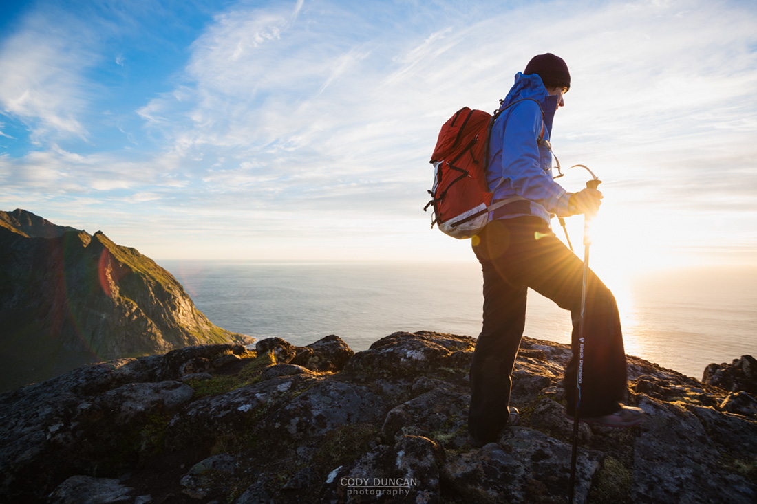
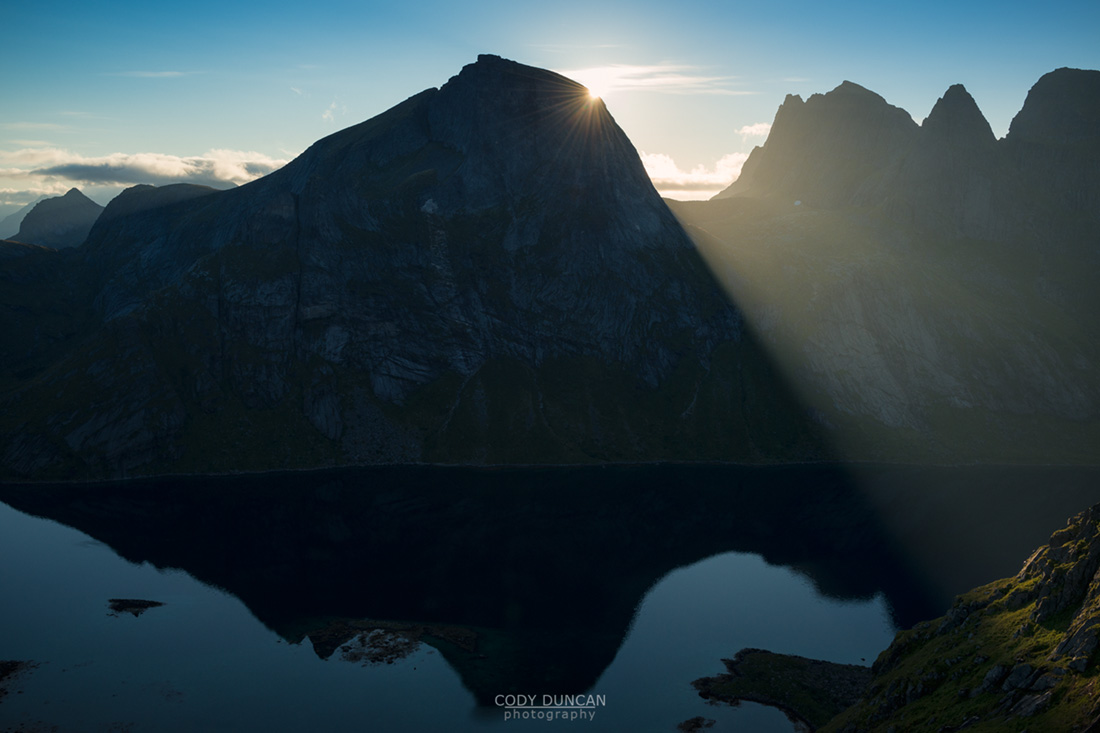
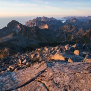
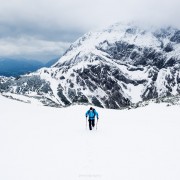
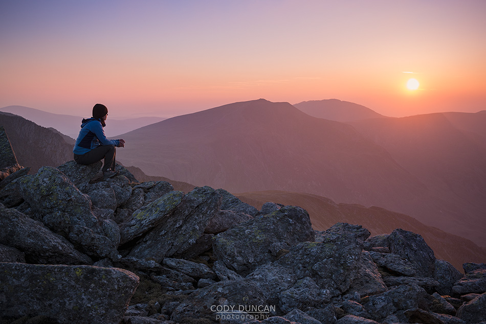
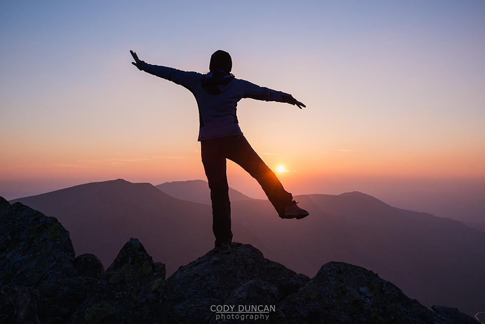
Photo: Hiking into the sun on the summit of Ryten, Lofoten Islands, Norway.  August 2013

[ This is part 4 of my Summer 2013 travels on Norway’s Lofoten Islands: PART 1PART 2PART 3 ]

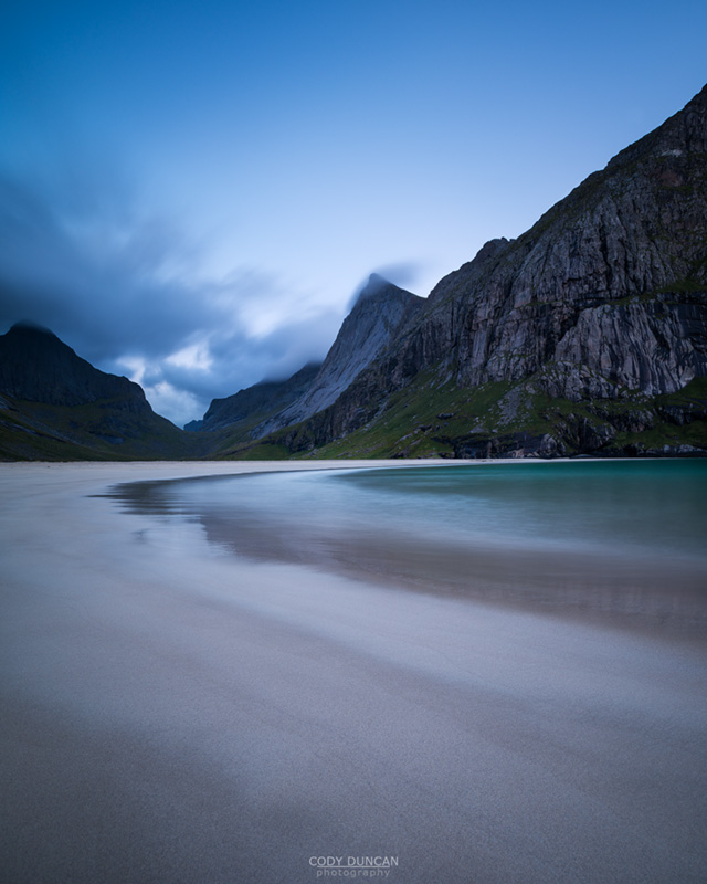
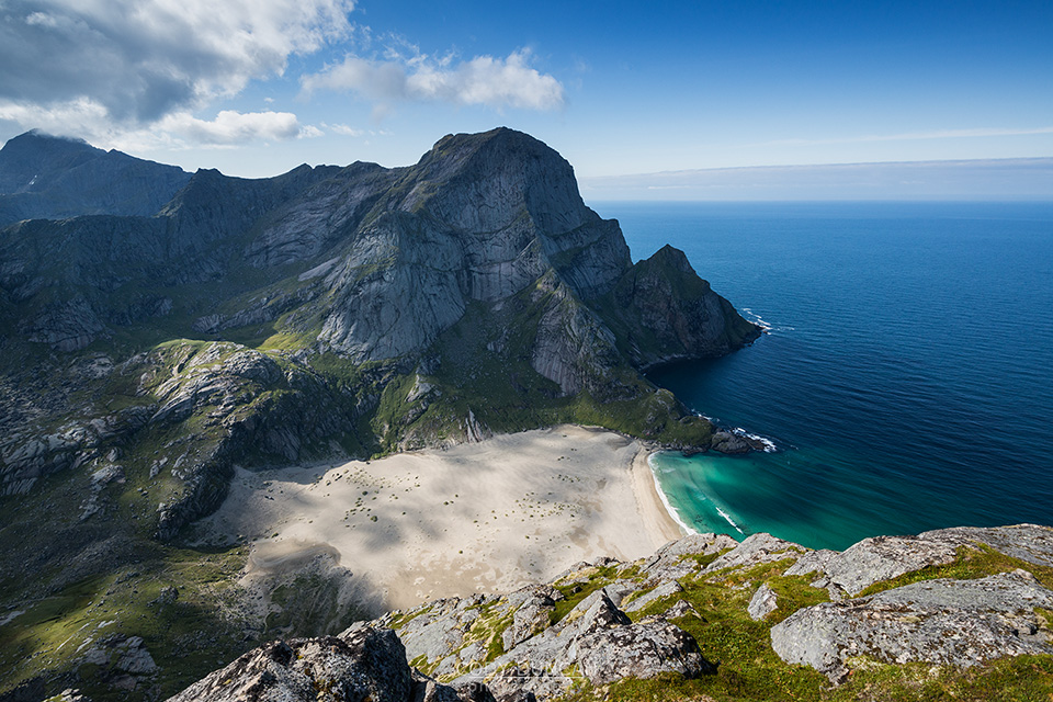
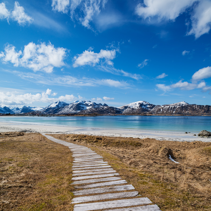
I fist visited Kvalvika beach in the summer of 2006, where I spent two days hiding in my tent for the rain to end.  It never did.  Since then I’ve learned the advantages of checking the weather forecasts and now have had a few wonderful nights camping at the beach.  It remains one of my favorite places in Lofoten; relatively easy to get to and amazingly scenic.  But the best views are not from the beach itself, rather from the nearby peak of Ryten, which if you have been to Kvalvika, is the 500 meter vertical cliff on the right side of the beach.

Friday morning I cruised my mid 90’s Subaru rental car away from Stamsund and headed west towards Kvalvika along roads that are now more familiar than those of my own hometown. I think I know every curve of the E10 by heart and can find all the pullouts even under 2 feet of snow – except when there’s too much snow, and I end up just getting stuck.  Nearing the parking to the trailhead I saw a large bus parked.  Uh oh!  I hope there’s not going to be a school group camped at the beach!

By late morning, the backpack was on and we were making our way towards the beach.  Since my last visit in April, a kind person has placed some stones and boards across the more boggy sections in the start of the trail.  Thank you!  I often wonder why the Norwegians don’t use more of the ‘mountain sidewalk,’ as I like to call it, planks of board run across particularly boggy sections of land, which is rather prevalent in next door in Sweden.  The opinion of the Norwegians seems to be that you either wear giant boots or suffer with wet feet.  Though often unsightly, the ‘mountain sidewalk’ actually does help in keeping the trail from spreading multiple meters wide as people attempt to circumvent the bog.  But so it goes.  There are not many people in Norway anyhow…

Within 30 minutes or so of hiking, Kvalvika beach finally comes into view and I can always feel my pace quicken at this point.  Though this is where the trail becomes a bit steeper and rougher as it descends towards the beach, so a bit more caution is needed.  Still worried about the school group camping on the beach, I looked down and scanned for an encampment of tents that would probably resemble an invading Roman army.  Nothing came into sight.  A bit further down the hill I observed a bit of movement and then my eyes focused on what looked like the a large animal migration from some nature documentary.  It was the school group leaving the beach and hiking up towards me.  I will say, that I really appreciate the Norwegian/Scandinavian ethic of getting kids out into the wilderness at a young age, you can really tell this enjoyment of nature carries on throughout their adult lives, and much more so than in my fellow countrymen.  But it is something as an American I’ve never really experienced out in the wilds.  I know enough not to expect mountains to be empty in Europe and popular places like Lofoten.  I just wish the groups could sometimes be a little smaller.  And hopefully not end up camping at the same place as myself.  Luckily, we gave our greetings as we passed and we arrived to the beach almost empty.

From up high, there seems to be an unlimited assortment of camping areas.  Upon closer inspection the grassy bluffs at the back of the beach are thoroughly covered in sheep shit, how do you think the grass stays so short all summer long, and sometimes a bit of careful cleaning up might be required.  But overall, there is a wonderful assortment of places for a tent and you should generally have no problem finding a place, even on a crowded summer evening.  I have a favorite spot out past the ‘not-to-be-named-hut-at-the-secret-beach-in-an-award-winning-film-by-some-Norwegian-surfer-dudes,’ and luckily no one had set up there for the night.  After pitching the tent it was off to search for firewood on the well combed beach of late summer and there is generally a bit to find if you search hard enough.

I always feel a haste to head right up Ryten.  But when I look at my watch and realize there’s 6 hours until sunset, it’s best not to rush things too much.  It can be a long, cold, wait at the top.  On this afternoon though, there was a layer of cloud hanging above the horizon, so I decided to head up around 6:00 pm, with a sunset around 8:45 pm, so as to hopefully get some nice light across the beach

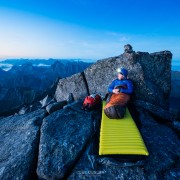
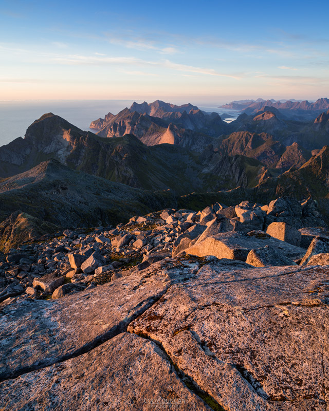
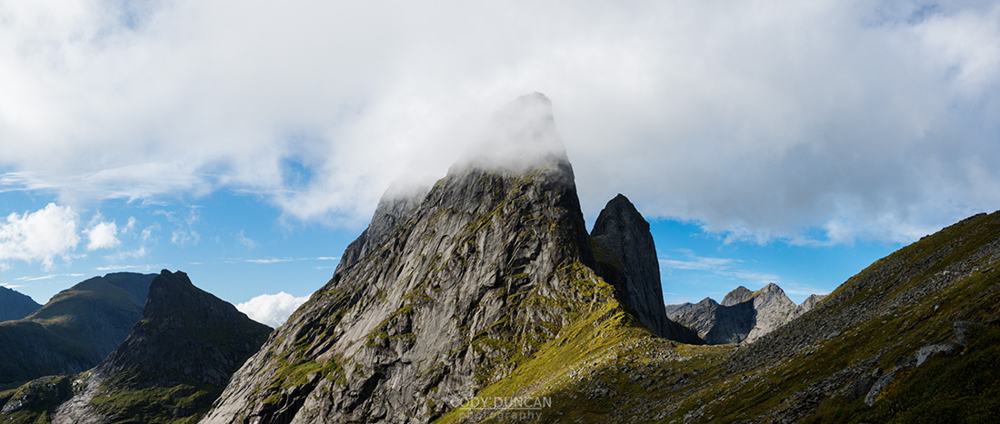
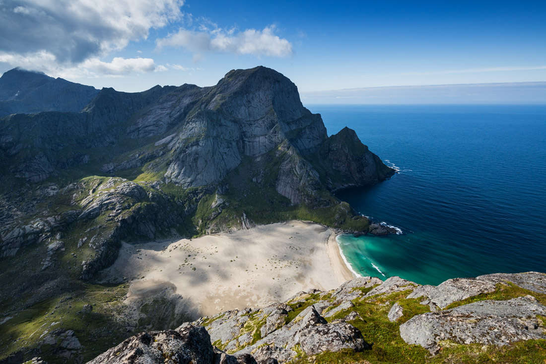
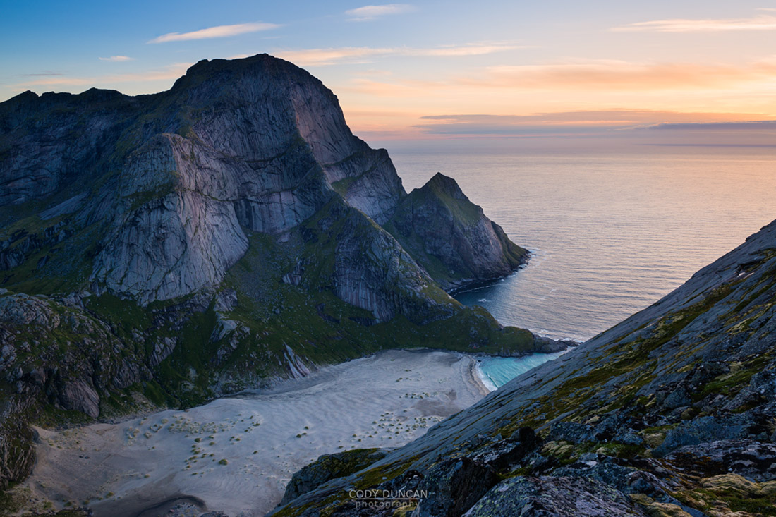
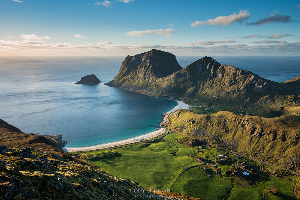
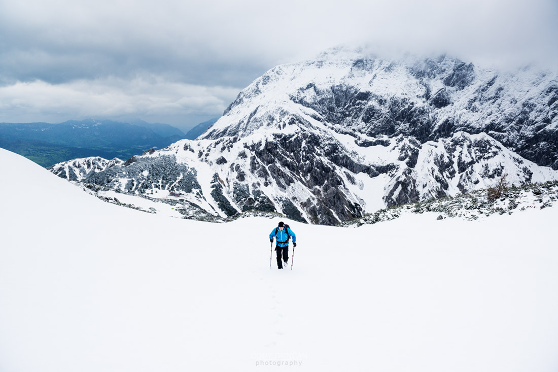
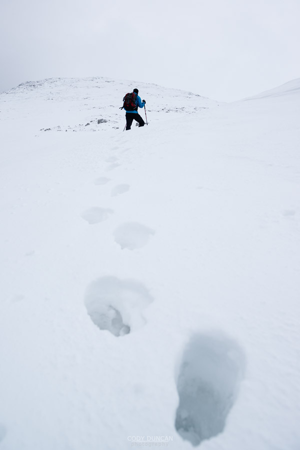
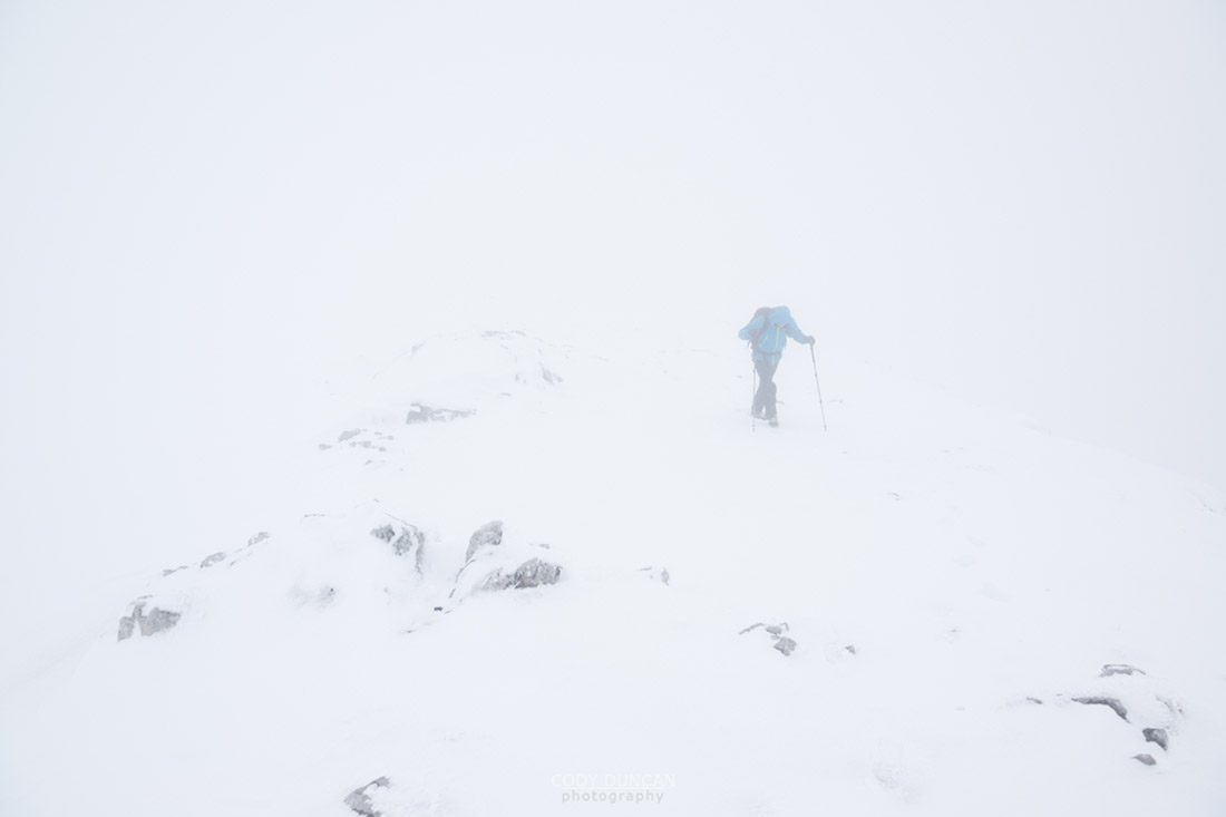
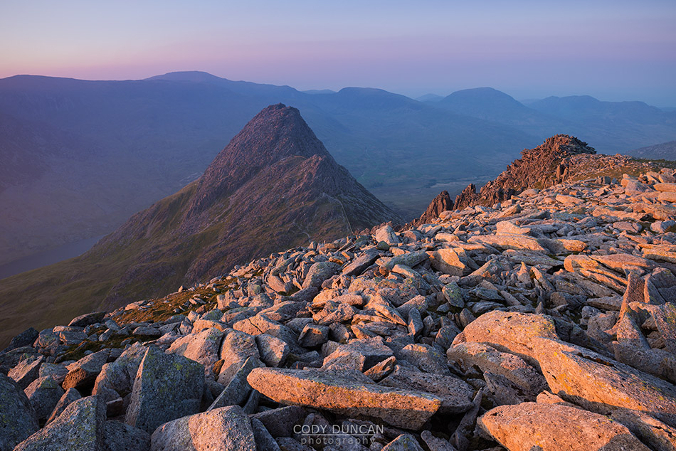
Ryten is one of those mountains that looks higher than it really is and the 500 meters can actually go by pretty quickly.  Just start walking, maybe with some good music coming out of your Ipod, and you’ll soon find yourself nearing the top.  The view from Ryten towards Kvalvika is best as an afternoon/evening photo, when the sun will be in the northwestern sky and shine directly into the beach, which is shaded by high mountains from every other direction.  And actually, the end of August is already a bit to late in the season for the beach to be fully illuminated, the sun now setting too far to the south to fully shine across the beach without being blocked by the surrounding peaks.

Female hiker overlooking Kvalvika beach from nearby mountain, Moskenesoy, Lofoten Islands, Norway

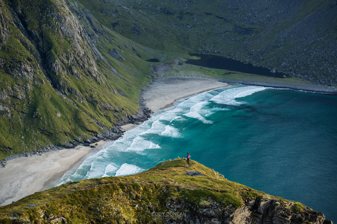
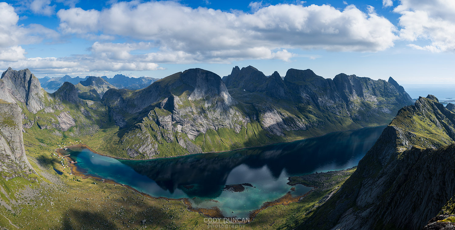
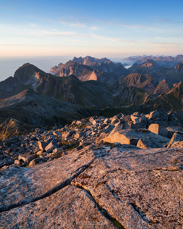
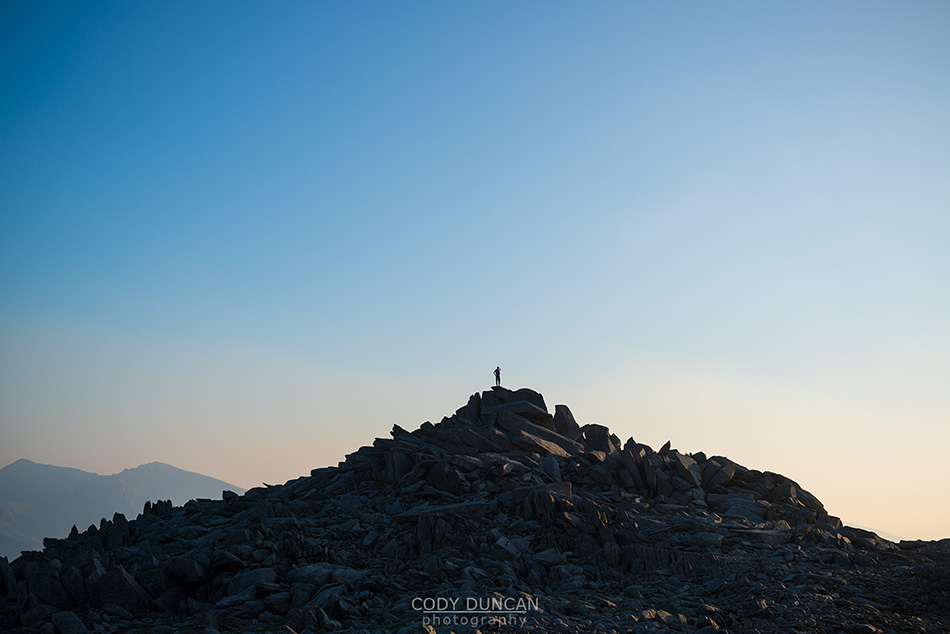
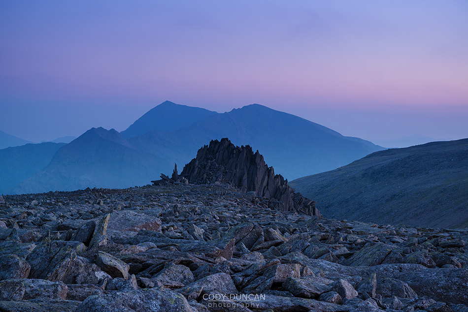
Photo: Halfway up Ryten, the views are getting good! Lofoten Islands, Norway.  August 2013


Female hiker enjoying view of Kvalvika beach from near summit of Ryten, Moskenesoy, Lofoten Islands, Norway

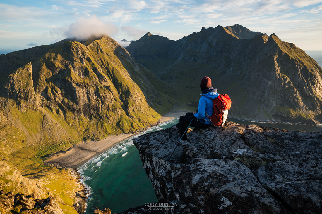
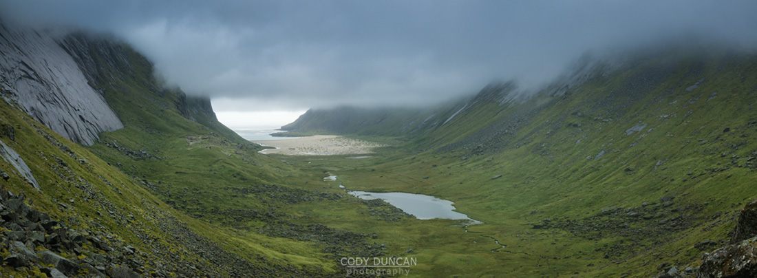
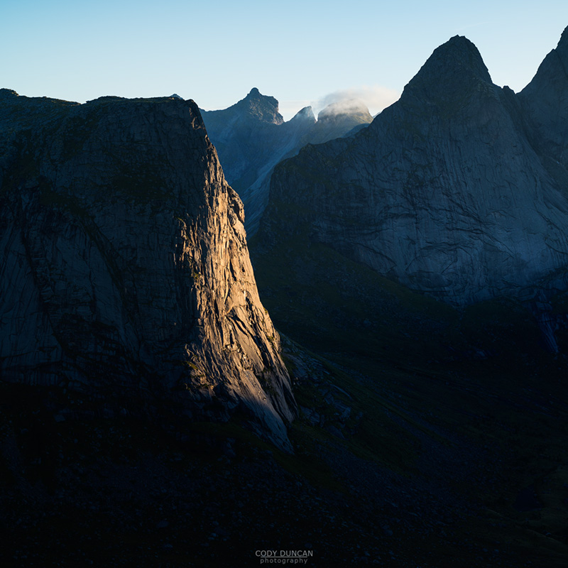
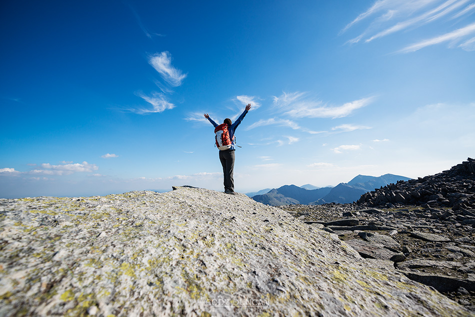
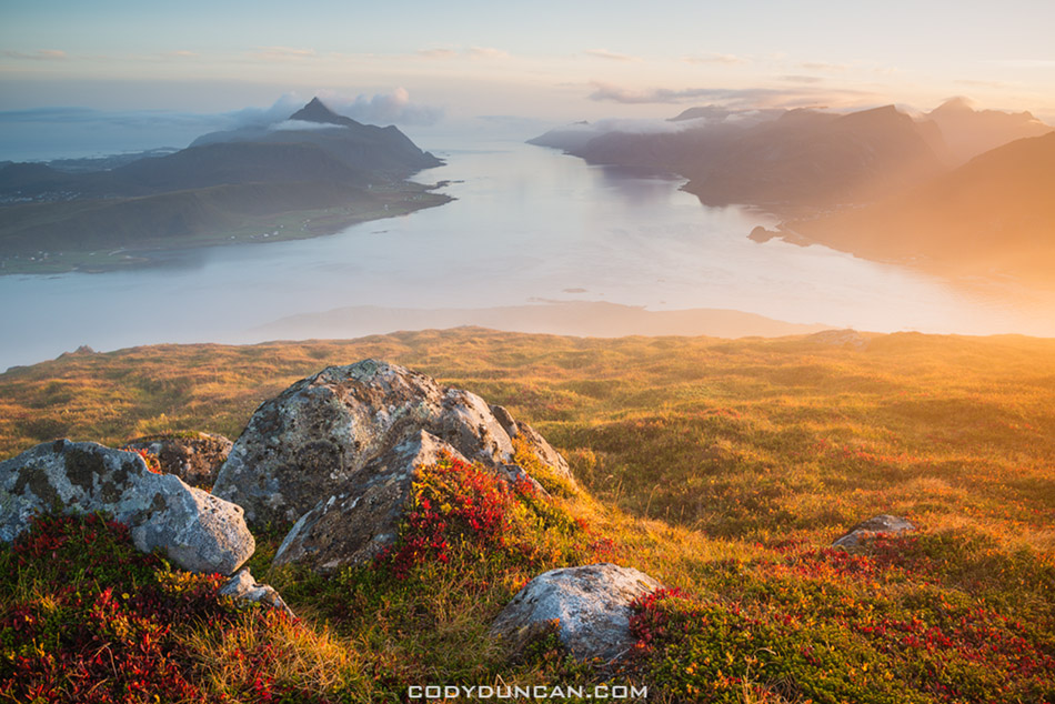
Photo: Overlooking Kvalvika beach, 500 meters below, Lofoten Islands, Norway.  August 2013

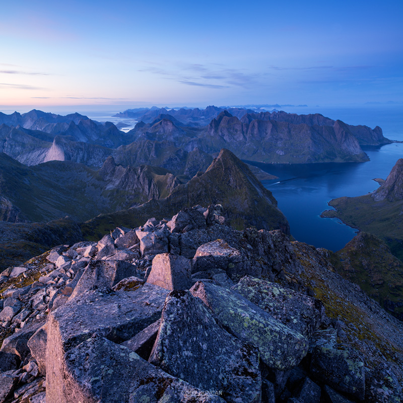
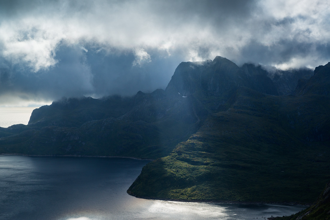
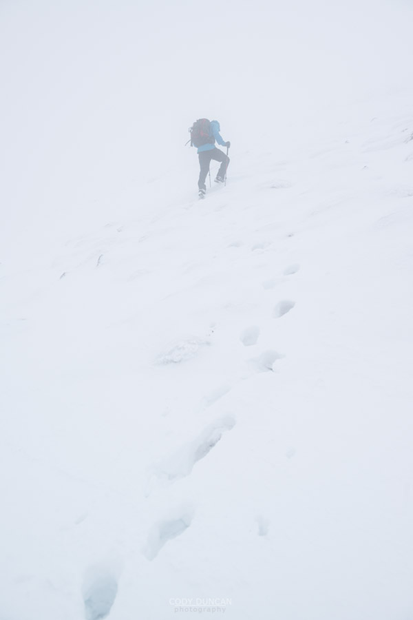
While the winds had been calm when leaving the beach, upon reaching the final summit ridge to Ryten it was evident that conditions had changed and a  cold east wind was blowing across the summits.  It was quickly evident that it would be somewhat pointless waiting around until sunset, such as I did on an even colder and windier day in May, as I would struggle to keep my tripod from falling over, much less get anything resembling a sharp photo in the fading twilight.  So with the sun just about to sink below the sea we were heading back down the mountain.

The sky was turning a nice color as I was nearing the beach.  Somewhat distracted with the scenery, I took a careless ‘hop’ off a grassy step and then landed on a surface that was far slipperier than I was expecting.  My foot immediately slipped, then turned sideways as my leg folded and I found myself heading face first into the small creek just above the beach; my leg now bent in an unhealthy position beneath me.  Fuck!  I was 20 feet from the sand, yet I slipped and fell.  As I righted myself I could feel that something was wrong in my foot.  Not wanting to waste time with checking things out incase I would be completely unable to walk in a few minutes, I put as much weight on my trekking poles as possible and hobbled across the beach and back to the tent.  By the time I arrived my ankle had already become quite swollen and too painful to put any weight on.

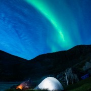
I was pretty sure nothing was broken, but hell, it hurt!  What I was hoping would have been a nice evening shooting photos late into the night turned into something of a suffer fest.  I did my best to enjoy the campfire we built, but it was a struggle, sitting awkwardly on the plank of wood turned bench upon which I could never get comfortable.  After an hour or so like this, Northern Lights appeared in the sky.

Normally Northern Lights would be a joy to me, especially so early in the year.  But now all I thought about was pain.  Unwilling to let the opportunity go to waste, I crawled on my hands and knees, careful to avoid the numerous piles of sheep shit, to someplace that seemed like a decent composition.  Luckily things worked out that it was the best framing for me to lay on the ground.  So that I did for the next 20 minutes until the lights faded and I once again crawled back to the tent.  After that exertion I decided it was time for bed.

Illuminated tent with Northern Lights in sky at Kvalvika beach, Moskenesoy, Lofoten Islands, Norway

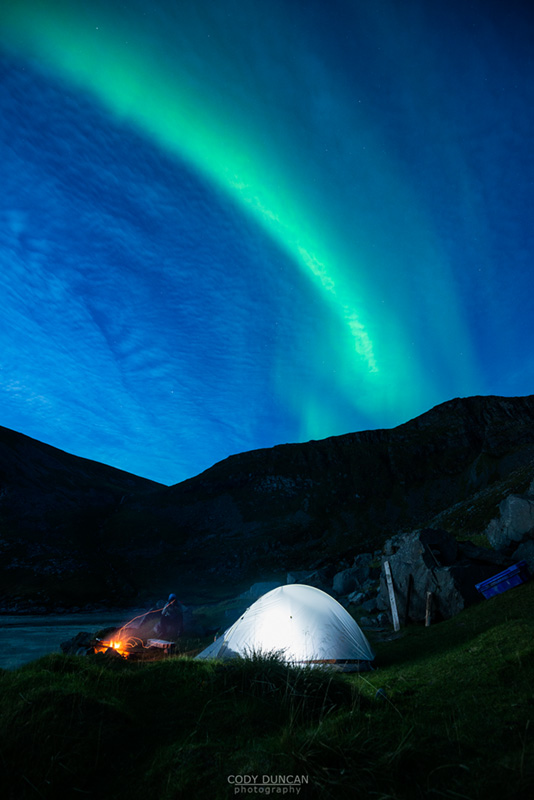
Photo: Northern Lights over my tent at Kvalvika beach, Lofoten Islands, Norway.  August 2013

I didn’t take any pain medication, wanting to know how bad my ankle really was, and if I’d be able to hike out in the morning.  My foot throbbed into the night.  I didn’t sleep.

The moment of truth came with the morning as I crawled out of the tent and made my first attempt to stand.  It was painful, but not overwhelmingly so. Now I loaded myself on Ibuprofen and for the first time in 12 years of carrying it through the wilds, had to use by ace wrap to tie up my ankle so it would remain as inflexible as possible.  The hike normally takes me about 45 minutes, now I was imagining something more along the lines of 2 hours.  Slow and steady my motto would be.  And so the journey back to the car slowly began, step after painful step.  It took a while, but eventually we made it back to the car.  No need for any sort of rescue operation.  But as Roar later informed me once back in Stamsund, I wasn’t in too much danger anyhow, ‘The farmers would be collecting their sheep in a few weeks, and could have taken you back with them…’

Random brand mixed vegetables, usually some mix carrots and peas, are the cheapest cold item to buy in the supermarkets of Norway.  And so this is what iced my ankle over the following days.  There was some nice light and I would have been tempted to the mountains, but I now had something bigger on my mind.  Would I be able to hike 7 days on the Kunsleden trail in Sweden, which would begin in less than two weeks!

I was forced to remain seaside for my last few days on Lofoten.  Not the way I would liked to have finished the trip, but at least the sprained ankle came at the end, not the beginning!  And luckily my ankle was not as bad as it could have been and there was no need for a (expensive) doctors visit. After a few days, despite some ugly looking bruising, I was about 40% mobile on horizontal ground.

Finally, it was Wednesday, September 4th, and time to depart the islands for Germany.  Normally I would enjoy the 1km walk to the Hurtigruten ferry terminal as a bit of time to clear my mind for departure, but thankfully a friend offered us a ride this time.  I was raining anyhow…

And so another Summer on Lofoten ended.  I knew I would be back in a few weeks, so it was not really a proper goodbye.  Little did I know at the time though, that I would be back in little more than a week, after my camera decided to take a Swim in Sweden

Scenic Myrland beach, Flakstadoy, Lofoten Islands, Norway

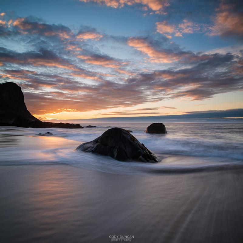
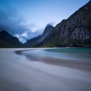
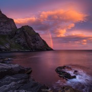
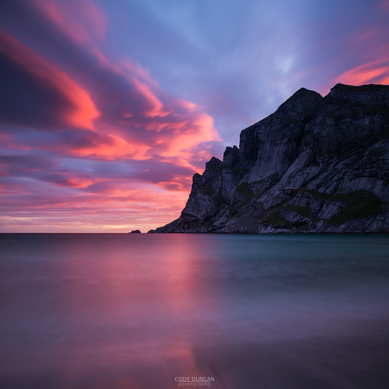
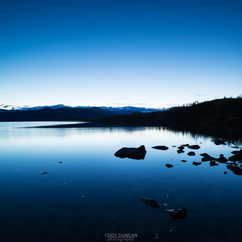
Photo: Sunset at Myrland beach, Lofoten Islands, Norway.  September 2013


Scenic Myrland beach, Flakstadoy, Lofoten Islands, Norway

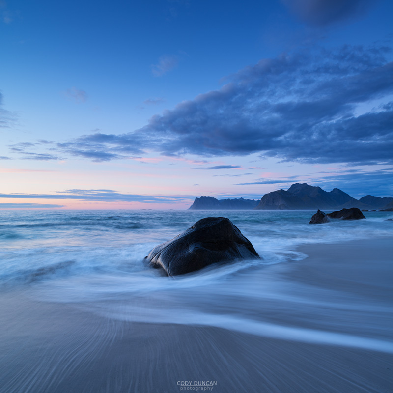
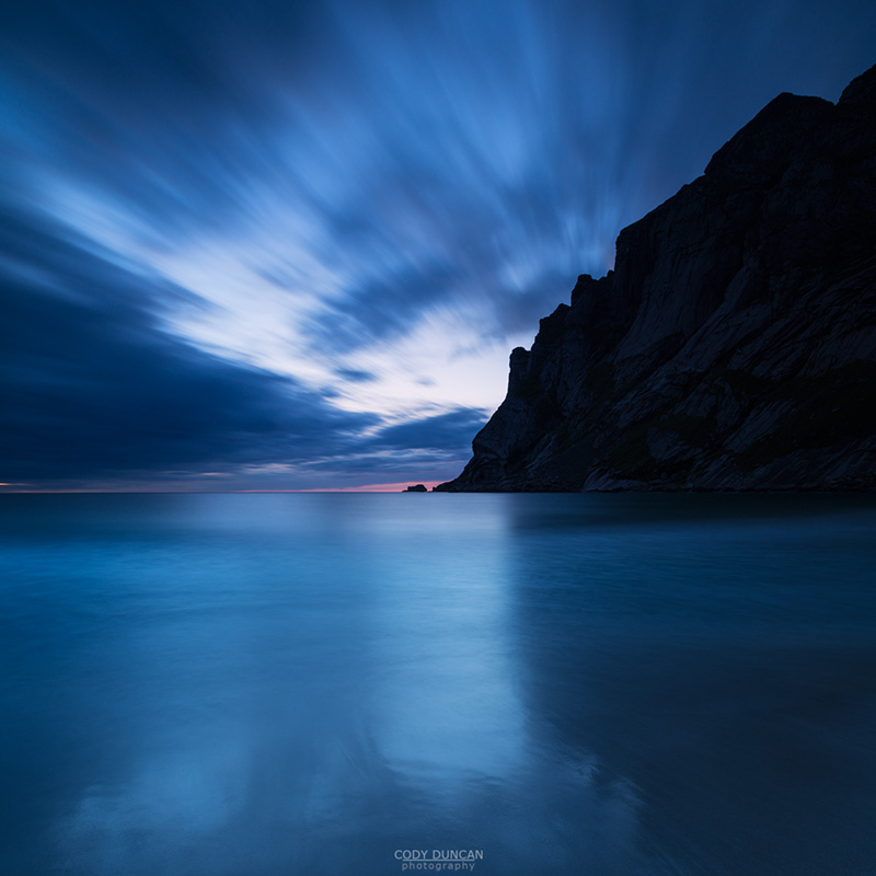
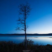
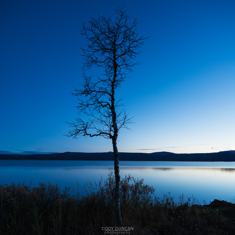
Photo: Evening Twilight at Myrland beach, Lofoten Islands, Norway.  September 2013

mountain bivy on rocky summit of Hermannsdalstinden, Moskenesoy, Lofoten Islands, Norway

Lofoten Islands Summer 2013 – Part 3 – Hermannsdalstinden

Evening light over mountain landscape from rocky summit of Hermannsdalstinden, Moskenesoy, Lofoten Islands, Norway

Photo: Endless mountains as seen from the summit of Hermannsdalstinden, Moskenesoy, Lofoten Islands, Norway.  August 2013

[This is part 3 of my summer travels: go here for PART 1PART 2 ]

The Hostel at Stamsund, Justad Rorbu og Vanderhjem, the formal name, but everyone just calls it Stamsund, is a magical place and one of the reasons I fell so much in love with Lofoten during my first stay there in the summer of 2001.  The hostel is simple and charming, set in an older fishermen’s building now around a hundred years old, with the tide lapping against the rocks underneath the kitchen – dining room floor.  Over the years it has become a home away from home for me, and hundreds of others who return year after year.

My arrival on this stormy morning was completely unannounced, with few people even knowing I was on the islands.  Yet as I walked in the door of the kitchen to the large group of people sitting around the table I was immediately greeted, ‘Cody, hello!  When did you get here?’

‘Oh hello Cody, I have just made some tea, would you like some?’

‘There’s still some food left on the table, help yourself if you’d like something to eat…’

And so before I could even change out of my smelly clothes or take a shower, I found myself sitting around the table, recounting stories of my last days and hearing about the travels of others whom I might not have seen for a year or two, and trying to put to memory the names of a few new faces whom I’m sure I’ll see around again in the coming years.  Only in Stamsund.

It was now Monday, August 19th.  As afternoon carried on, the rain fell heavier and heavier.  Tuesday it also rained, Wednesday as well as Thursday it continued.  But the forecast for Friday afternoon and the weekend looked promising.  And so I formed plans for the morning, Hermannsdalstinden.

Friday morning I said my goodbyes and caught the bus out of Stamsund to make my way to Reine and again take the ferry.  This time however, I wasn’t going to Bunes or Horseid beaches. I was heading towards Hermannsdalstinden, which, at 1029 meters above the sea, is the highest mountain on Moskenesøy, and the western half of Lofoten as a whole.  It is a rugged and impressive peak that has been on my Lofoten ‘to-do’ list for quite some time, but for some reason has never worked out.  This time I would be in luck.

Twilight light over mountain landscape from rocky summit of Hermannsdalstinden, Moskenesoy, Lofoten Islands, Norway

Photo:  Twilight arrives on Lofoten, Hermannsdalstinden, Moskenesoy, Lofoten Islands, Norway.  August 2013

There are two approaches to Hermannsdalstinden.  The main route begins in Sørvågen and heads inland, passing the Munkebu hut, before continuing on towards the mountain.  The second option is to take the ferry from Reine to Forsfjord.  This has the benefit of saving you a few kilometers of hiking, for the cost of 120 NOK ferry ride(!). The savings in horizontal distance earns you a steep, slippery ascent until the two trails meet.  Once you leave the boat in Forsfjord, there is no going back.

CLICK HERE for hiking route info on Hermannsdalstinden.

As the afternoon ferry departed Reine the sky was still partially filled with low, peak concealing clouds of mist rising in the strong sunlight.  The water of the Reinefjord was like glass, and the boat sped across the surface into the perfect reflections of the surrounding mountains.  After a couple stops to drop off some mail and pickup passengers returning from the beaches the boat entered the deep shadows of Forsfjord and it was now my turn to leave.  Despite a rather full boat, I was the only one to exit in Forsfjord.  I was now alone, only 5 kilometers and 1029 meters ahead of me.  It was 3:45 PM.   I watched for a moment as the boat disappeared in the distance and then began my journey.

The benefit of the Forsfjord route is that you save over half of the (horizontal) distance to the mountain.  The tradeoff is that you convert distance into a steep, slipper slope, at times having to pull on the bracken and trees to keep from slipping backwards as your feet struggle to take purchase on the muddy slopes.  It is somewhat of a relief that after reaching the half way point of the first climb the trail begins to follow a series of rock bands and steps, making for sometimes more exposed, but altogether easier travel.  After 200 meters of ascent the shores of the first lake are reached.  Only 800+ meters to go!

I was initially unsure of where I would camp for the night as I knew the summit to be rocky and not overly conductive to camping.  I had received a bit of beta from some others that there was something of a grassy ledge below the summit that would work for a tent.  Knowing it was unlikely to rain I wasn’t overly worried about shelter. At worst, I would find as flat of a rock as possible to lean against during the short night of late August.  If the weather did turn bad, I could just sit around in my rain gear, or begin hiking back down the mountain.

A little after 7:30 PM I scrambled around the last few boulders and found myself just below the summit.  The sun was getting low on the horizon so I tossed my backpack against some rocks and got to work taking photos.

I never saw anything looking like a good spot for a tent, but I did find several good options to bivy for the night.  I finally decided on a nice flat rock that, although quite close to the edge, was protected by a few rocks that would most likely keep me from rolling off and falling 30-40 meters.   I settled myself in for the night as the last bit of twilight was fading from the sky and the full moon rising higher above the Vestfjord.  At some point in the night the winds picked up in strength and brought a bit of a chill.  I cinched up my bag so that only my nose was visible.  The moon was bright overhead.

mountain bivy on rocky summit of Hermannsdalstinden, Moskenesoy, Lofoten Islands, Norway

Photo: My bivy spot on the summit of Hermannsdalstinden, Moskenesoy, Lofoten Islands, Norway.  August 2013


Lofoten Islands Sunrise from Hermannsdalstinden, Norway

Photo: Warm greetings of the morning’s sun, Hermannsdalstinden, Moskenesoy, Lofoten Islands, Norway.  August 2013


Hermannsdalstinden, Lofoten Islands, Norway

Photo: Dark clouds fill the sky as I descend from the mountain, Hermannsdalstinden, Moskenesoy, Lofoten Islands, Norway.  August 2013

I was up before 05:00, waiting for what the day would bring.  An uneventful sunrise as it turned out.  But I was thankful for the warmth as the first rays of light pierced the cold morning air.  The steam of my tea drifted into the breeze as I held it tightly to heat my hands.  And so there I sat, alone, watching sunrise on the top of Lofoten and wondering what another day in the north would be bringing me.  It was one of those moments that’s probably nicer to share with others, but if you cannot, it’s still better to be there than not.

After an hour of so I noticed some eerie looking clouds beginning to form over the mountains to the west, and combined the the ever increasing wind, I figured I should probably start heading down.  For the second time on this trip, I found myself descending a mountain in the early morning.  Seems a bit odd, with the full day ahead, but so it goes…

Half way down I sat and watched clouds swirling over the peak which was now full concealed with any remaining blue sky being consumed by a wall of gray from the west.  By 10:00 the sky was completely filled dark and forlorn looking clouds.  I passed some others making their way up the mountain and wished them luck, I would not have liked to be heading in their direction.  The difference 15 hours can make.

Soon enough I found myself arriving at Munkebu hut.  Somewhat tired and with nowhere in particular to go I set up camp.  I gave though to heading up Munkan, and had the weather been better, I would of.  But the summit was in the clouds so I laid in my tent and slept the afternoon away.  Lazy life, that of a mountain photographer.

The following morning brought an uneventful hike down to Sørvågen and then what I can only describe as pathetic attempts to hitchhike back to Stamsund.  I managed get a little past Hamnøy, before going nowhere for an hour + of standing on the side of the road until the only bus of the day came and took me to Leknes.  It was a Sunday after all, not good for hitching I guess..  With no busses to Stamsund, I ended up walking about halfway and catching a couple rides.  My feet were now thoroughly sore by this point.  Reaching the hostel, I setup a mattress in the sun outside and once again took a nap.  Exhausted.

Monday brought rain once more.  As did Tuesday.  Blustery weather came on Wednesday before then things began to calm a bit on Thursday.  And finally, in what seemed to be a developing pattern on this trip, the weekend’s forecast was once again good looking.  A plan was made – Camp and Kvalvika beach and hike up Ryten for sunset.  This would be my third time doing this combination of beach and mountain, and it what is now one of my favorite overnight tours on Lofoten.

…Continued PART 4

Storsandnessanden beach looking towards mountains of Vestvagoy, Lofoten Islands, Norway

Photo: Summer rain passes over Vestvagoy, Lofoten Islands, Norway.  August 2013


Waves break across rocky coastline at Unstad beach, Vestvagoy, Lofoten Islands, Norway

Photo: Passing storm at Utakleiv beach, Vestvagoy, Lofoten Islands, Norway

Horseid beach, Lofoten Islands, Norway

Lofoten Islands Summer 2013 – Part 2 – Escape

Horseid beach, Lofoten Islands, Norway

Photo: Heavy clouds hang over Horseid beach, Lofoten Islands, Norway.  August 2013

[Lofoten Islands Summer 2013 Part 2.  Part 1 -HERE- ]

As I reached the summit of the pass between Kjerkfjord and Horseid beach, proper rain turned into heavy rain.  I was also hiking fast and getting hot.  I should have changed into a synthetic shirt, but believing that the rain would only last a few more hours I foolishly stayed in a cotton shirt, which proceeded to get wetter and wetter from my sweating under the burden of my heavy backpack.  By the time I reached the beach, heavy rain had turned into torrential rain, with drops so big they hurt.  I was becoming increasingly soaked by the combination of sweat, rain, and sideways blowing wind.

Reaching the small grassy bluff at the far end of the beach, it was a mad dash to set up my tent beneath the falling sky.  I am quick with tents.  But by the time I through my backpack inside, jumped in and closed the rain fly, everything was wet and I was completely soaked through and through.  Pools of water formed under my dripping wet rain gear as I placed it in a corner of my tent in a haphazard attempt to keep the rest of the tent from getting wet.  My only hope at this point was to strip down to my underwear, crawl into my sleeping bag and hope my body heat would dry me off while I waited for the rain to end.

Hour after hour passed and the rain still fell.  Evening came, then night and the rain continued, unbroken.  I didn’t bother with cooking dinner.  Finally sometime around 03:00 the clouds broke and the winds came.  In the predawn light, I used my tripod, along the the guy-lines from my tent to setup a poor-mans clothes line by which I would attempt to dry my clothes.  The winds blew stronger and stronger, with my tent flattening out once again.  By 06:00 I was fully packed, dressed in semi-moist clothing, with the wettest stuff tied to the back of my backpack.  Despite the early hour, I was ready to get out of there as it looked like a full on storm was about to arrive.  Sand stung me as I crossed the beach and progress was slow as I walked into the winds.

Horseid beach, Lofoten Islands, Norway

Photo: The rain has stopped, Horseid beach, Lofoten Islands, Norway.  August 2013

Instead of returning back to Kjerkfjord and the ferry to Reine, and shelter, I took the steep muddy trail that would lead me beneath the steep spire of Kråkhammatind before descending into the lush valley of Fagerådal and eventually finishing at the DNT mountain hut at Selfjord.  On the map, the trail looks relatively straight forward, but in reality, it is often steep, muddy and rocky, with very few moments where one can simply walk.

While I heated myself up to a sweat on the steep ascent, once gaining the pass I exposed to the full front of near gale force winds, and quickly took a break to put on all my jackets.  I would have liked to camp up here, but there was no way my tent would survive in such conditions, so I continued on.

Sunlight pierces through clouds on Solbjørnvatnet, Moskenesoy, Lofoten Islands, Norway

Photo: Stormy sky over lake Solbjørnvatnet, Lofoten Islands, Norway.  August 2013

Clouds conceal dramatic mountain peak of Kråkhammartind, Moskenesoy, Lofoten Islands, Norway

Photo: Clouds conceal the summit of Kråkhammartind, Lofoten Islands, Norway.  August 2013

Scenic mountain valley around lake Fageråvatnet, Moskenesoy, Lofoten Islands, Norway

Photo: View towards lake Fageråvatnet, Lofoten Islands, Norway.  August 2013

Green summer birch trees below dramatic mountain peaks, Moskenesoy, Lofoten Islands, Norway

Photo: Green Birches of Summer, Lofoten Islands, Norway.  August 2013

The descent to shores of lake Fageråvatnet was particularly treacherous under the weight of my heavy backpack, with steep sections of loose moss covering otherwise bare, wet rock at 45 degree angles or more.  Loss of footing would have lead to a bad fall or twisted ankles.  Once reaching the lower ground, the trail twisted through trees, over rocks, under rocks, until finally reaching the inner waters of the fjord where it turned into Lofoten super bog.  To this point I had kept my feet more or less dry.  On the last 1 km of trail, this was a hopeless effort and I gave up trying to hop between the ever shrinking, and sinking, dry clumps of grass.  Luckily by now the sun had come out and it was actually beginning to look like a nice day.

The standard Norwegian DNT hut key works for opening the door at the Selfjordhytte, a group of two cabins an a couple out buildings at the end of the fjord.  Upon my arrival I was greeted by a nice French woman who informed me of the news that the water pumps were not working.  The nearest source of water?  Back across the 1 km of bog to a small stream.  I knew I should have filled up my water bottles as I passed!  So before settling down for the afternoon, it was time for more wet feet.

Another text message weather forecast told me that a big storm would be arriving in the morning.  But now into early afternoon the day was actually hot and the winds seemingly gone.  Though a German couple arriving later that afternoon also from Horseid beach informed me that it remained quite stormy and cloudy there.  Such is the changeability of Lofoten. I was in bed before dark, a real bed this time, alarm set for 05:00.

Rain fell in waves throughout the night, but seemed to have backed off as I walked out the door of the hut at 06:00, the sky dark an ominous looking.  I had 12 km walking along the road ahead of me, with no chance of shelter and little chance of catching a ride as there are only a few scattered houses along the way.  Once I left, there would be no return and I would be at the mercy of whatever the sky decided to throw at me.  Despite the chill in the air, the wind, and the off and on sprinkles of rain, I hiked in a t-shirt, so fast I was trying to walk.  In just over an hour I passed the trailhead to Kvalvika beach and knew I was just over half way to the E10 and a good place to hitch a ride.  Or if that failed, the bus would come by at 10:00.

Reaching the outskirts of Fredvang, the rain grew heavier than I would have liked and I was back in my waterproofs for the remainder of the walk.  In a little over 2 hours I reached the E10.  Not bad for 12 km or road on an empty stomach!  A few cars passed, but I must have been a bit rough looking, and none stopped for what seemed like an eternity.  Until finally, a young German family pulled over and could take me all the way into Leknes.  With a light rain still falling, I walked a few blocks to the main road to Stamsund and as luck would have it, a car driven by a Polish electrician quickly pulled over and took me to the corner of the hostel.

I put on backpack for one last time and walked down the familiar road towards the yellow buildings on the edge of the sea.

…Continued PART 3

Rainbow at Sunrise over mountains from Bunes Beach, Moskenesoy, Lofoten Islands, Norway

Lofoten Islands Summer 2013 – Part 1 – Arrival

Bunes beach as viewed from Helvetestinden, Moskenesoy, Lofoten Islands, Norway

Photo: Bunes beach as seen from the summit of Helvetestinden, Lofoten Islands, Norway.  August 2013

[This is part 1 of a multi-part series on my summer 2013 travels to Norway’s Lofoten Islands]

Perhaps sometime in the future the trip from California to Lofoten will be shortened, but for now it remains a nearly two day journey.  I can’t help but feel that  there’s something slightly masochistic about walking out the door on a Tuesday morning and not finally laying flat and properly closing your eyes until Thursday afternoon.  But until I can move somewhere more convenient, this is my fate.  Or maybe I just need to earn enough to fly business class, that would reduce the burden somewhat.  But like any place that draws you, the journey is worth it…

The main delay in my travels is often the ferry connection from Bodø to Moskenes.  For some reason I always arrive in Bodø in early evening, usually just missing a ferry and having to wait until the next.  Though this time, knowing there is nothing in Moskenes at 04:00, I actually skipped the midnight sailing out of Bodø, choosing to wait until the 04:30 boat, which arrives at a more civilized 08:00.  Really, unless you actually have a place to be at 04:30 or are with a car, it is more comfortable to wait in Bodø than in Moskenes.  A lesson I have learned, more than once, the hard way.

In my normal fashion of travel to Lofoten, my plan was to ‘get there and see.’  I had several options in my head, all of which where dependent on the weather.  The lazy person, and tired traveler in me, sometimes wishes for rain so I can conveniently hide away on a soft bed in Stamsund for a couple days to catch up on sleep.  The photographer in me wants some dramatic light, while the hiker in me wants sunny blue skies.  Blue skies with nice puffy white clouds I got.

Departing the ferry in Moskenes in perfect weather I now was down to two options from my to-do list: Hermannsdalstinden or Helvetestinden and Bunes and Horseid beaches.  With my backpack feeling a bit on the heavy side, along with my head, I contented myself with the easier option of Helvetestinden.  I managed to unusually quickly hitch a ride with a group of Polish and was soon in Reine.  Now all I had to do was sit around for a couple hours for the next ferry boat Vindstad, my attention fixated on my watch and how many hours it had been since I actually got any sleep; somewhere around 38 hours by this point in the morning.

Summer crowds of tourists filled the boat on the wonderful day.  Departing the boat in Vindstad, I was the first one making my way through the small village before finally leaving them further behind as I veered from the main trail and began the steep hike towards Helvetestind.

You can find the hiking route info for Helvetestinden – HERE

View towards Kjerkfjorden and mountains of Moskenesoy, Lofoten Islands, Norway

Photo: Kjerfjord seen from the hike up Helvetestinden, Lofoten Islands, Norway.  August 2013

Sweating under the strain of my 25kg backpack in the hot sun, not something I get to complain about very often in Lofoten, I did my best to conserve the little water I carried, knowing I would have no chance to refill on the summit.  To my surprise, there were a couple other groups of hikers heading up the mountain this day, including two british and even a fellow American, often a rare sight on Lofoten for some reason.

Not exactly sure of where to camp, I carried my backpack nearly to the summit before dropping it off as I reached a few steep rock steps that I wasn’t too sure I’d like to go back down with a heavy bag.  I spent some time on the top and thought about camping up there, but the more sheltered spot lower down on the saddle of the ridge I had seen earlier seemed a safer option.  And only a 15-20 minute hike back up, it wouldn’t be too bad the following morning for sunrise.  Leaving with the others after 30-40 minutes at the top, I set up camp and pretty much fell asleep by two o’clock in the afternoon.  Exhausted.

Bunes beach as viewed from Helvetestinden, Moskenesoy, Lofoten Islands, Norway

Photo: Evening twilight over Bunes beach, Lofoten Islands, Norway.  August 2013

I headed back up the mountain in the evening, but the puffy white clouds of the afternoon had disappeared and a layer of sun-eating haze hung low on the northwestern horizon.  And so it was back to my tent for some more sleep until my wakeup alarm at 04:00.

Morning brought blue skies once again.  Sunrise wasn’t too spectacular from my camping spot as the surrounding mountains blocked the first hour’s worth of sunlight, with the mostly east – west running fjord remaining deep in shadow until the sun rose higher in the sky, by which point all color was gone.

Morning light on Merrastitinden from near summit of Helvetestinden, Moskenesoy, Lofoten Islands, Norway

Photo: First rays of morning light from Helvetestinden, Lofoten Islands, Norway.  August 2013

Sunrise behind Rostadtindan from near Helvetestinden, Moskenesoy, Lofoten Islands, Norway

Photo: Rays of light shine over Kjerkfjord, Lofoten Islands, Norway.  August 2013

Even though I took my time packing up camp, I found myself heading down the mountain before 07:00.  I was, however, in the complete opposite of a rush, my destination being Bunes beach, at a whole 45 minute – 1 hour hike away.  Call me lazy!  Though by this time I was more or less completely out of water, only having carried 2.5 liters up the mountain with me and some 24 hours since my last refill.

The morning also brought wind.  Upon reaching the beach I first proceeded on with the nearly 20 minute walk to the far left side of the beach to look for a place to camp out on the point beyond the lone cabin.  But seeing several campers struggling in the blowing wind to take down their tents, and unable to find a suitably sheltered stop, I returned to the grassy dunes at the back of the beach.  Even here though, it was windier than I would have liked, and my poor, lightweight Big Agnes Fly Creek Platinum tent was doing it’s best to remain upright.  Thankfully, though the tent nearly completely flattened out at times, the poles held.

Still short on sleep, I slept away the morning and afternoon amid the flapping of my tent.  Finally rising in early evening I noticed a layer of grey cloud had filled the sky.  I made two rewarding trips out to the water’s edge: once for sunset and a few hours later at twilight.  A little after midnight I was once again cozied up in my sleeping bag.

Sunset at Bunes Beach, Moskenesoy, Lofoten Islands, Norway

Photo: Summer twilight at Bunes beach, Lofoten Islands, Norway.  August 2013

The morning came all to early.  At the sounding of my first alarm, I peaked my head out the tent to see what looked like a dull gray sky in the dim twilight.  Closing my eyes for a few more minutes, I tried to pretend I was somewhere else so I could at least enjoy a few more hours sleep.  But somewhere in the back of my mind found the energy to fight off my laziness and got myself dressed. I was here to take photos after all, not sleep!

As I reached the water, the sky was glowing bright pink from behind the mountain.  It was some of the best light I’ve seen in Lofoten for a while.  I would have been content with what I photographed there with the waves breaking across my feet.  Wet shoes again!  An odd sense of intuition filled my mind and I left the beautiful scene to continue on around the point to see what was on the other side.  Normally, this is where I end up missing the light all together, having gambled on something better than light I should already have been content with.  But when the rainbow and glowing orange clouds came into sight, I nearly panicked in a rush to find a good position and not miss what I was seeing.  I wanted to shoot stills, I wanted to shoot video, I wanted to shoot a time-lapse sequence or two.  I needed another one of me, each with 4 arms to help do everything at once!

I was saved by the north.  With the low angle of the moving sun against the horizon when compared to lower latitudes, light ‘lasts longer’ on Lofoten.  That is to say, sunrise will last 2-3 times longer than you are used to back home.  And thus I had nearly 20 minutes of light as the rainbow emerged from behind the mountain until it finally faded away in the growing daylight.  So glad I got out of bed!

As I walked back to my tent I contemplated that I had not even been on the islands two full days and I’d already had better light than I’ve often waited weeks for.  I thought about catching a few more hours sleep, but the now darkening sky of cloud foretold of rain – as did my text forecast that I try and receive on a daily basis.  I packed up camp and began walking back towards to ferry pier in Vindstad.  A light mist began to fall.

Normally, the 24 hour weather forecasts are pretty accurate for Lofoten.  But there are however often some micro-climates in particular fjords or valleys that buck the trend.  With the forecast saying that rain should only last until 1-2pm, I made the decision to continue on with the ferry to Kjerkfjord and hike to  Horsied beach for the night.  But in the back of my mind, knowing that it was a southwest wind, I thought I was perhaps being a bit overly optimistic.  And I was.

Departing the ferry in Kjerkfjord, the sky was a solid gray, clouds hanging low over the pass with a proper rain beginning to fall.  Proper in that I put on my waterproof pants.  This was my second time hiking to Horseid beach, and my second time hiking to Horseid beach in the rain.  Such is how it goes on Lofoten.

…Continued – PART 2

Colorful sunrise over mountains at Bunes Beach, Moskenesoy, Lofoten Islands, Norway

Photo: Pink sunrise over Bunes beach, Lofoten Islands, Norway.  August 2013

Rainbow at Sunrise over mountains from Bunes Beach, Moskenesoy, Lofoten Islands, Norway

Photo: Rainbow sunrise at Bunes beach, Lofoten Islands, Norway.  August 2013

Lake Sitojaure, Kungsleden trail, Sweden

When A Camera Goes Swimming

Lake Sitojaure, Kungsleden trail, Sweden

Photo: Evening twilight on lake Sitojaure, Kungsleden Trail, Lapland, Sweden.  September 2013

It was at 9:00 am on a crisp September morning that I learned a valuable, no, expensive, lesson: camera’s can’t swim.

The journey from Germany to the north of Sweden was a long one.  A flight from Berlin to Stockholm’s Arlanda airport.  An afternoon sitting around the airport.  A night train north of the arctic circle to Gällivare – top bunk in a 6 bed cabin, no open windows,  the Italian family I shared the cabin with was not too keen on fresh air.  I tossed, turned, and sweated through the night with dreams of cold mountain air and colder autumn nights.  Come morning it was a couple hours by bus followed by a short boat ride the the STF mountain hut Saltoluokta.  The beginning of my journey into the mountains.

Morning rain cleared and the birch forests shined in the brilliant colors of fall. The sky filled with blue and the arctic sun floated above the southern horizon.  All was perfect.  I could feel my excitement growing at the promise of the days ahead and the simple task of putting foot before foot, mile upon mile, day after day.  After waiting around for the shop to open so I could purchase fuel for my stove, I began my journey southward, the 24kg of my backpack my only burden.

Before me was 20 kilometers of trail to the shores of lake Sitojaure and the next hut.  After a short time wandering through the forest the trail soon ascended to a barren mountain plateau.  Warmed by the sun I was down to a t-shirt by this time and I witnessed a new phenomenon I’ve never seen in Sweden before, dust.  So dry the summer and autumn had been in the north.

Having slightly sprained my ankle while hiking in Lofoten at the end of September, I was slightly worried that this would perhaps cause me to have to cancel the trip.  I wasn’t sure if I would travel all the way to Sitojaure and left the option open of finding a nice campsite for the night if I so desired.  Luckily the hours passed by and as long as I was careful with my steps, all remained well as I headed deeper into the mountains.  The sun shining bright I soon realized that I had come all the way to Sweden to get a sunburn.  Perhaps I should not have left the sunblock at home after all.  Though I guess getting a sunburn in Sweden is not something to complain about, given the alternatives I’ve experienced in previous years. I had more sun this afternoon than in the entire 10 days of my hike in 2009.

Soon enough I found myself descending back into forest towards lake Sitojaure.

There were only four of us in the cabin that night.  Myself, and Austrian, and two Dutch.  At least I had a room to myself and wouldn’t have to worry about any snoring, though tiredness would likely keep me in an undisturbed sleep anyhow.

At some point I filled out my name in the guest book.  Some moments later one of the Dutch guys asked, ‘Have you filled out the book?  Is Cody here?’

Somewhat surprised, ‘Ya, that’s me. Why?’ I reply.

‘Oh, cool!  We have read your website.’

Sometimes, by the lack of comments I get on my posts I figure no one reads my words or sees my photos.  But for the second year in a row now, I’ve unexpectedly met people on the trail who have read my guides for the Kungsleden.  Feels good to know that I can be a bit of help or inspiration for people heading up to these beautiful, yet somewhat udocumented, parts of the world.

As twilight arrived I wandered down to the shores of the lake to make a few images.  Little did I know, these would be my camera’s final moments of life.  Perhaps I would have put in a little more effort otherwise.  When the sky was finally black I returned to the hut and curled up in my sleeping bag for the night.  Thoughts now turned to my boat journey in the morning and hoping the lake would not be too foggy for me to navigate the 4km I would have to row to the other side.

Now, normally during this season, there is a water taxi, for the steep fee of 200 SEK, that can take you across the lake; typically running twice a day.  In a change from my normal cheapness, I figured it would be nice to take it so as to save some effort.  And perhaps I could get some cool footage as well.  But upon my inquiring with the hut warden, I was informed that the boat driver man would be off early in the morning to help with the autumn reindeer herding, and thus there would be no boat.

The alternative to the water taxi are the row boats.  Each lake, which can’t be hiked around, along the Kungsleden trail has 3 row boats.  The system is that there must always be 1 boat on each side of the lake.  If you are lucky and there are 2 boats on your side of the lake, you will only have to make the journey once.  If you arrive and find only 1 boat, it means you will have to row to the other side, pickup the 2nd boat and tow it back to where you came from, leave it there, then row back again.  Crossing the lake 3 times in total.  Fortunately for me, I had the 2 row boats on my side of the lake, meaning I only had to make the journey once.  The thought of 12km of rowing on fresh arms was something I didn’t want to think about, and thankfully didn’t have to.

I rose with arrival of the sun to a frozen autumn day, but also a cloudless blue sky and hardly a hint of wind.  The lake was like a mirror, perfectly reflecting the surrounding landscape.  I took my time with breakfast, giving the land a bit of time to thaw out before I would begin my journey.  And so finally, shortly before 9:00am I said my goodbyes and made my way to the boats.  I would be the only one heading south this day.

Now in my brilliance, and in an effort to document my journey along the trail, I figured I would shoot a time-lapse sequence of me rowing across the lake.  So I setup my camera and tripod towards the back of the boat and began shooting the sequence.  Only the boat was still somewhat pulled up on the shore, so as I returned to the front of the boat, I had to lean out the side a bit to push myself off and out into the water.

As the boat inched it’s way into the water, it suddenly slipped from a rock that was underneath and lurched towards the right as it became fully afloat.  Out of the corner of my eye I caught my tripod (and camera) lean towards the right, balance against the edge of the boat for a split second, and then topple over, upside down into the water.  The water was shallow and my reaction was fast as I grabbed hold of one of the tripod legs, which was left sticking up out of the water, and pulled my camera out.  I quickly grabbed my fleece and tried to dry it off, but I could tell I was likely too late as water distorted the view finder and fogged the lens.

For several moment, I sat there in silence, contemplating what I had done.  I could have cried, where I not so angry with myself.

I went back to the hut and started the fire in the kitchen and did my best to take the camera apart with what screws could be loosened with the my pocket knife – pretty much only the viewfinder cover, if you’re wondering.  I alternated between the fire and some time outside in the sun for the next hour, but I could tell it wasn’t likely to come back to life, especially not out there.

And so I made the decision to call off the hike.  What would I do out there if I couldn’t take photos?  Not to mention the now dead weight of all my camera gear.

I left behind a bit of food, which I now no longer needed, so as to at least lighten my backpack by a few kilos and began retracing my all too fresh steps back north again.  My frustration and the desire to hopefully catch the afternoon ferry from Saltoluokta fueled a frantic pace.  In just over 3 hours I was descending into the forest and towards the shores of the lake.  Though I was not fast enough and missed the ferry by 20 minutes.  One more night in the mountains for me.

That night bright auroras filled the sky for hours.  I couldn’t watch.  I should have been in my tent, camped above Rapadalen.  Yet there I was, a camera-less photographer.  Helpless.

It took me two full days of travel, including a rainy night in Narvik, for me to get back to Stamsund on the Lofoten Islands, where I knew I would have a comfortable place and good company to wait out the days until I received a new camera.  All and all it took two weeks before I had a camera in my hands again.  Thankfully, the weather gods must have felt some sympathy for me.  Once reunited with a camera the weather remained calm and clear.  I headed into the mountains day after day in a furious pace to make up for lost time, now with only six days left in the north.  And I did my best to make the most of them…


Lake Sitojaure, Kungsleden trail, Sweden

Photo: Lone tree in autumn, lake Sitojaure, Kungsleden Trail, Lapland, Sweden.  September 2013

Kungsleden Row boat

Photo: Image #19,521, the last my Nikon D800 would ever take. Lake Sitojaure, Sweden.  September 2013

Evening light over mountain landscape from rocky summit of Hermannsdalstinden, Moskenesoy, Lofoten Islands, Norway

Lofoten Mountain Hikes


Evening light over mountain landscape from rocky summit of Hermannsdalstinden, Moskenesoy, Lofoten Islands, Norway

Photo: View across Lofoten from the summit of Hermannsdalstinden, Lofoten Islands, Norway.  August 2013

As I mentioned yesterday, here are some links to the new mountain pages I’ve added in the last weeks over at 68 North.

Hermannsdalstind – 1029m – Moskenesøy

Helvetestind – 602m – Moskenesøy

Holandsmelen – 434m – Vestvågøy

If you want to see the complete list of mountain hiking and beach guides, you can do so HERE.

Of all the hikes I’ve completed on Lofoten now (only a small percentage of what the islands have to offer), Hermannsdalstinden is by far the highlight.  I’m not sure any other peak on the islands can have equal views.  Of course this is also somewhat dependent on weather, and I happened to have near perfect timing for Hermannsdalstinden.  But what a fantastic mountain!

I don’t know why it took me so many years to finally get up there.  Though I think in previous years I have been a bit more focused on getting a variety of shots, so spending a whole day or two on one mountain didn’t make as much sense to me.  But now that I have pretty much photographed all the low hanging fruit the islands have to offer, the only way I can get new work out of the islands is to head up into the hills, which seems to be paying off thus far.  My ‘to do’ list grows ever larger…

Holandsmelen Lofoten Islands, Norway

Photo: Vik and Haukland beaches from the summit of Holandsmelen, Lofoten Islands, Norway.  September 2013

Bunes Beach from Helvetestinden, Lofoten Islands, Norway

Photo: Bunes beach from the summit of Helvetestinden, Lofoten Islands, Norway


Spring Hiking on Schneibstein, Berchtesgaden national park, Germany

Finding Winter in Spring

Spring Hiking on Schneibstein, Berchtesgaden national park, Germany

Photo: Spring 2013 conditions on Schneibstein, Berchtesgaten national park, Germany – Austria.  May 2013

It has been a running joke among a few friends of mine for the last several years that I have an uncanny ability to attract abnormally bad weather.  I actually used to boast that the California sun followed me wherever I headed, but for the last 5+ years I’ve seemed to have lost that power.  Now I travel in my own personal rain, or snow, cloud wherever I seem to end up.

The Germans had a long, dark winter this year.  And that is nothing due to me.  But as I landed in Munich in mid May after a previous two weeks on the Lofoten Islands in northern Norway, the temperatures felt absolutely tropical.  Walking the streets of Munich to my hostel as the midnight hour neared, I was in a full on sweat under the heavy load of my backpack, without wearing a jacket.  And so it was with a fairly optimistic outlook that my friend Till and I set our sights on some easy hiking in the Alps.

As we passed Chiemsee on our way to Berchtesgaden on a Monday afternoon, passing rain showers clogging up the normally fast moving autobahn, it was apparent that maybe our glasses were at bit too rosy.  Or plans had been for Watzmann, the second highest peak in Germany, but as we neared Königssee, it became apparent that this would be an unlikely objective.  Not to mention that I only had some light hiking boots, as I hadn’t left California planning on full on Winter mountaineering.

With clouds concealing all the high peaks, we caught the one of the last cars on the Jennerbahn up the mountain, entering into snow and blasting winds as we left the station at 1,800 meters.  If it was truly bad, I knew we could stay at Carl. V. Stahl Haus at Sneibstein pass on the German/Austrian border.  But it was only pretty bad, so we reached the hut, we decided to continue on up into the mountains in the direction of Schneibstein, 2276 Meters.  I was here last October, in a brilliant t-shirt weather week of indian summer so I more of less knew where I was going.  But as we ascended a bit further, into the whiteout of the clouds, the trail became near impossible to follow.  Finding a fairly decent flat area in the snow, we decided to set up camp for the night and see what morning would bring.

The night was cold and windy, not to mention that I only had a 0˚C sleeping bag with me.  Perhaps not the most comfortable night of my life, but still a ways off from the worst.

Morning arrived with passing moments of sunlight and raised clouds, at least high enough for me to see Schneibstein’s summit at set my bearings.  We continued up the mountain, probably the only ones having made this journey since the storm arrived several days previously with a fresh dumping of snow.  At times we struggled through drifts up to waist deep, as we watched the cloud layer begin to lower.

I knew more or less the correct way to go, or we would not have continued once we entered the whiteout, with visibility to each other limited to about 10 meters or so.  And with a 500 meter cliff near vertical cliff near the summit, it wasn’t exactly a mountain to get lost on.

I could feel the way as we got higher.  If the weather got too shit, we still had enough time to follow our footprints back down the mountain.  Had I been alone, perhaps I would have turned around, but the hubris or companionship kept us going.  As the mountain began to flatten, I kew we must be close.  But it wasn’t until I was only 4-5 meters away from the summit cross that I could actually see it in the cloud, so covered in hoar frost it was, it was rendered near invisible.

Quickly chilled by the wind, we didn’t sit long on the summit before making our way back down the mountain.  The descent proved to be much quicker, me bum-sliding most the way down the snowy slopes.  Camp was quickly taken town and then we set of for the leisurely walk back down to the valley floor.

Spring Hiking on Schneibstein, Berchtesgaden national park, Germany

Photo: Deep snow while heading into the clouds, Schneibstein, Berchtesgaden national park, Germany – Austria.  May 2013


Spring Hiking on Schneibstein, Berchtesgaden national park, Germany

Photo: Ascending into the clouds, Schneibstein, Berchtesgaden national park, Germany – Austria.  May 2013

Spring Hiking on Schneibstein, Berchtesgaden national park, Germany

Photo: Nearing the summit in full whiteout, Schneibstein, Berchtesgaden national park, Germany – Austria.  May 2013

Whiteout on Schneibstein Summit, Berchtesgaten national park, Germany

Photo: Schneibstein summit, Berchtesgaden national park, Germany – Austria.  May 2013

Schneibstein Summit, May 2013, Berchtesgaden national park, Germany

Photo: Mandatory summit selfies, Schneibstein, Berchtesgaden national park, Germany – Austria.  May 2013


Wooden walkway leading to Ramberg Beach, Ramberg, Flakstadoy, Lofoten Islands, Norway

Archive Updates – Lofoten – Colorado – California

Wooden walkway leading to Ramberg Beach, Ramberg, Flakstadoy, Lofoten Islands, Norway

Photo: Ramberg Beach, Lofoten Islands, Norway.  April 2013

First off, hello and welcome to the new site!  I’ve been pretty bad at blogging the last few months, and that was mostly because I knew I would be doing a big site update and so sort of lost interest in things for a bit.  So, if I have any readers left, things should be more or less back to normal from now on.

I’m still not finished working on the site with a few pages still needing to be added and a few minor layout tweaks and the such.  But I think everything looks much better overall, especially with the blog and website now combined as one.

What’s New:

Articles – This is a new section to bring better attention to some of the longer or informational articles I’ve written on the blog.  As it had been, stuff would just get buried away as new posts piled on top, without an easy way of finding if I had any further info on a particular subject.  Now, over the following months, I’ll be adding stuff to the articles section of the homepage to help make things a bit more orderly and intuitive.

The articles will be divided into a few sections:
Travels: These will mostly be random stories written about various travels.  Mostly thoughts and musings, or stupid stuff I do.
Destinations: Here you’ll find location specific and informative articles about a particular place, ie ‘Hiking the Besseggen Ridge.’
Gear: I’ll talk about the gear I carry and use in this section. Hopefully I’ll eventually get around to adding reviews as well.
And in the future I’ll be adding an Events or Festivals section. I go to a lot of cool and obscure events around Europe that few other bloggers seem to write about or might be hard to find info in English about; I’ll be giving you details on the ‘when and where’

Prints – You can now see what prints I have available for sale without having to visit my Archive.

New Galleries – I hate to say it, but my last website had gotten pretty stale! My last update had been in 2010, so I’m more than a little overdue for new content. Although I’ve always posted links to the photos as I added them to my Archive, few of you ever headed over there, so a few new galleries are here now. With several more still to add.

Archive Updates:

3 new updates to my Archives.

Lofoten Islands – Spring 2013: Images from My April/May trip to the islands

Colorado: It has taken a while to get these edited and online. Images from my hiking and backpacking trip to Colorado last summer.

California: A few new photos Mostly from last summer in Yosemite: Tuolumne meadows and hiking Mt. Dana.

Sunset over flooded tuolumne meadows in summer, Yosemite national park, California, USA

Photo: Sunset over flooded tuolumne meadows in summer, Yosemite national park, California.  July 2012

descending from Handies peak (14053 ft), San Juan mountains, Colorado, USA

Photo: Descending from Handies peak (14053 ft), San Juan mountains, Colorado.  June 2012

sunset over mountains from summit of Glyder Fach, Snowdonia national park, Wales

A Night Camping In Snowdonia

sunset over mountains from summit of Glyder Fach, Snowdonia national park, Wales

Photo: Sunset from the summit of Glyder Fach, Snowdonia national park, Wales.  June 2013

A couple weeks back the alignment of two rare conditions occurred here in Wales: the weekend and good weather.  Really, it is a rare treat in this part of the world.  Or to quote a climber we passed on the way down from the mountains on Sunday morning, ‘Come back here 10 times and you’ll never have weather as good as this!’

We took to the road early on a Saturday morning for the 3+ hour drive north to Snowdonia national park.  Although only a couple weeks before midsummer and with plans to bivy somewhere in the mountains, we weren’t all that worried about time. After a slightly long lunch in Betws-Y-Coed, we were at the trailhead for the north ridge of Tryfan a little after noon.

The north ridge of Tryfan is supposed to be one of the classic ridge scrambles in Wales, and thus in the fantastic weather I was expecting to be hiking among huge crowds.  But luckily with our afternoon start, most of the people must’ve gone ahead of us and we enjoyed the ridge mostly to ourselves much of the way.

The sun was beating down and I was a bit worried about or water consumption on the way up, trying to conserve as much as possible of the 3 litters I was carrying which would need to last me the next 24 hours.  Luckily I had a sun hat with me here for some reason otherwise I would have ended up more sunburnt than I did.  Not that I’m complaining!

Sometime later we reached the summit of Tryfan, sat around for a bit, then headed down the south side to Bwlch Tryfan.  From here we headed along the trail leading east of the summit of Glyder Fach.  There were some nice tarns in the grassy flats here and I thought it could be a nice place to make camp, but maybe in poorer weather.  In these conditions, it would be a shame not to camp on the summit of one of the peaks, and so we headed up the easy trail to Glyder Fach.

Once on the summit, I found a decent place to set up the tent; we had been prepared to bivy in the open, but a steady wind was blowing so being inside a tent would be a more comfortable night.  With 5+ hours until sunset I started to think that maybe I should have brought a book to kill a little time.  Though finally the summer sun sank low on the horizon, but not before a dark band of haze had formed out over the sea, dashing any hopes of a spectacular sunset.  I think I more enjoyed the mild conditions in the mountains that I don’t think I’ll come across again for some time.  And despite the weather, we were the only ones staying on the mountain this night.

For some reason I though sunrise was at 3:50, not 4:50, so I woke up a bit early on Sunday.  The light was fairly dull anyhow, so after an hour or so of wandering around in the somewhat fresh breeze I found myself back in my sleeping back for a couple more hours when the sun finally lit up the tent too much.

After an easy walk to the slightly higher summit of Glyder Fawr we headed down out of the mountains along Llyn Idwal and finally back to the carpark by late morning.

Female hiker on Cantilever stone, Glyder Fach, Snowdonia national park, Wales

Photo: Blue skies over Snowdonia, Glyder Fach, Snowdonia national park, Wales.  June 2013

Female hiker on Cantilever stone, Glyder Fach, Snowdonia national park, Wales

Photo: Cantilever Stone on Glyder Fach, Snowdonia national park, Wales.  June 2013

Silhouette of lone hiker on rocky summit of Glyder Fach, Snowdonia national park, Wales

Photo: Glyder Fach, Snowdonia national park, Wales.  June 2013

Rocky summit of Glyder Fach, Snowdonia national park, Wales

Photo: Rocky summit of Glyder Fach, Snowdonia national park, Wales.  June 2013

Sunset over Tryfan from summit of Glyder Fach, Snowdonia national park, Wales

Photo: Tryfan from the summit of Glyder Fach, Snowdonia national park, Wales.  June 2013

Silhouette as female hiker balances on rock viewing mountain sunset from summit of Glyder Fach, Snowdonia national park, Wales

Photo: Sunset from Glyder Fach, Snowdonia national park, Wales.  June 2013

Castell y Gwynt - Castle of the wind with Snowdon in the background from summit of Glyder Fach, Snowdonia national park, Wales

Photo: Castell y Gwynt – Castle of the wind with Snowdon in the background,Glyder Fach, Snowdonia national park, Wales.  June 2013

Haukland beach winter, Lofoten Islands

New Lofoten Prints Available

View over Nappstraumen from summit of Offersøykammen, Vestvågøya, Lofoten Islands, Norway

Photo: Offersøykammen Autumn sunset, Lofoten Islands, Norway.  Oct 2012

I’ve added a few new (10 in total) prints from my last couple lofoten trips into my print gallery.
-click here to view the gallery-

As my last few journeys to the islands have been with my D800, I’ve increased the size in which these new images are available to be printed.  The newly available images are available to be printed up to:

20×30 – $50
24×36 – $80
32×48 – $95