Lofoten Islands Hikes – Justadtinden

Justadtind lofoten islands

Photo: Justadtinden rises in the distance

Lofoten Islands Mountain Hikes: Justadtinden

Justadtinden (738 meters) is the highest peak on the eastern side of Vestvågøya.  An easy and well worn trail through a scenic mountain landscape makes reaching the summit of Justadtinden a relatively easy hike and a good first introduction to the Lofoten islands.  While the summit itself is rather flat and slightly anticlimactic, the 360º view is still something impressive.  When the sun is out and the winds are calm, I imagine this would be a nice place for a picnic on a summer afternoon.

Photo: Winter view from Stamsundsheia. Justadtinden (738 meters) is flat summit on left, Kangerurtinden (704 meters) on right

Getting There

By Car: From north or south, take the E10 to Leknes.  From Leknes, take the 815 towards Stamsund.  After approximately 4km the road rises to the pass at Hagskaret (Where the large building is).  There are two parking options here on the left side of the road (before the building), one paved, one dirt.

From the parking area, take the dirt road towards the large antenna visible a couple hundred meters to the north.  Keep following the road straight.  After passing the antenna building on the right (don’t turn here), the road will soon end and turn into a hiking trail.  There are several trails that cross back and forth, keep in the general direction of the right (east).

Photo: Mountain landscape near Justadtinden
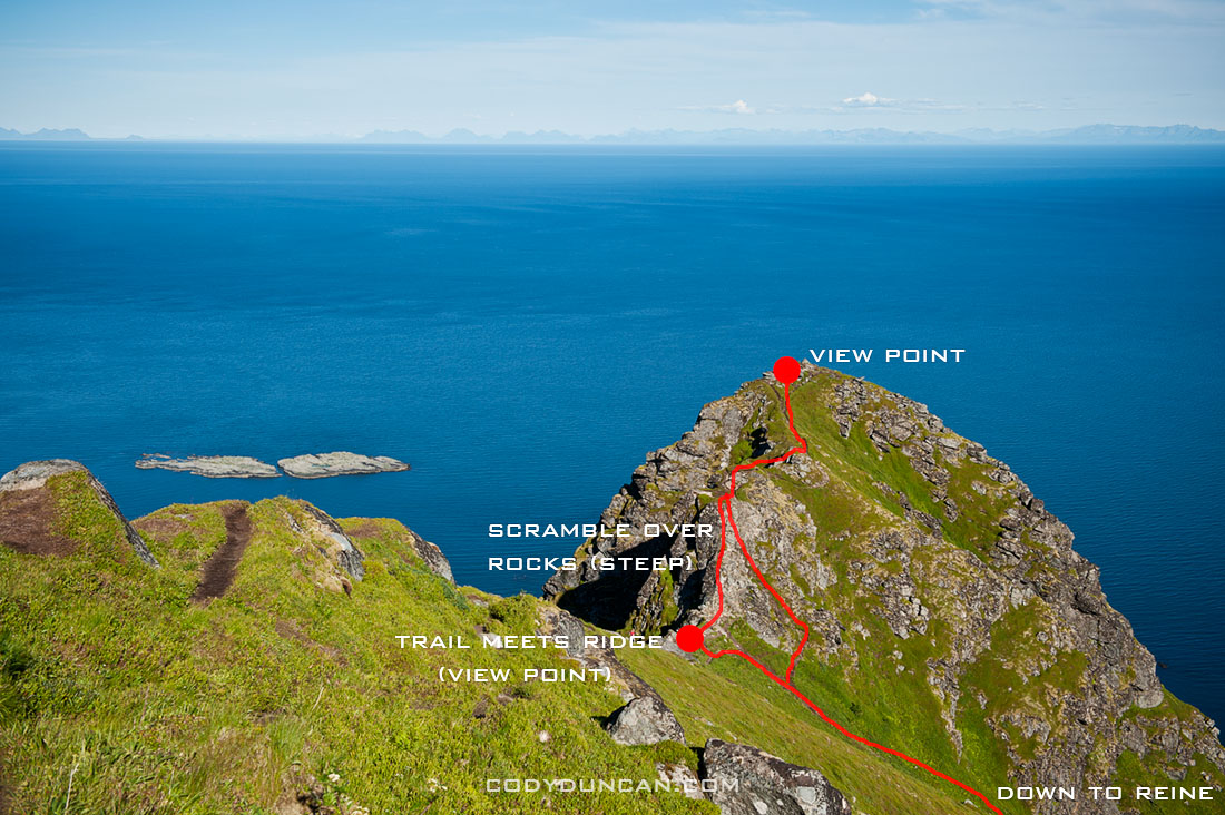
The Trail
From the start of the trail, the summit of Justadtind is approximately 6km away, with 600 meters of elevation gain.  The first half of the trail gently gains elevation while wandering through low hills and ridges.  The second half of the trail gradually increases in steepness (though still quite a gentle grade) and passes through a section of rocks shortly before the summit.  The rocky outcropping that appears as the highest point in the top.

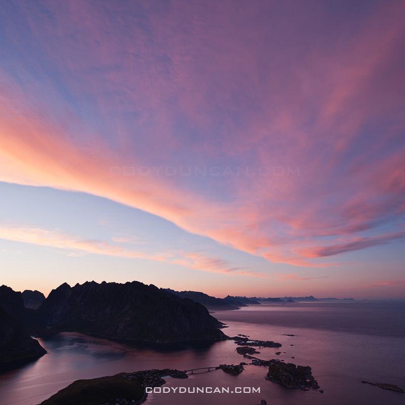
Photo: View from summit of Justadtinden towards Henningsvaer

Camping

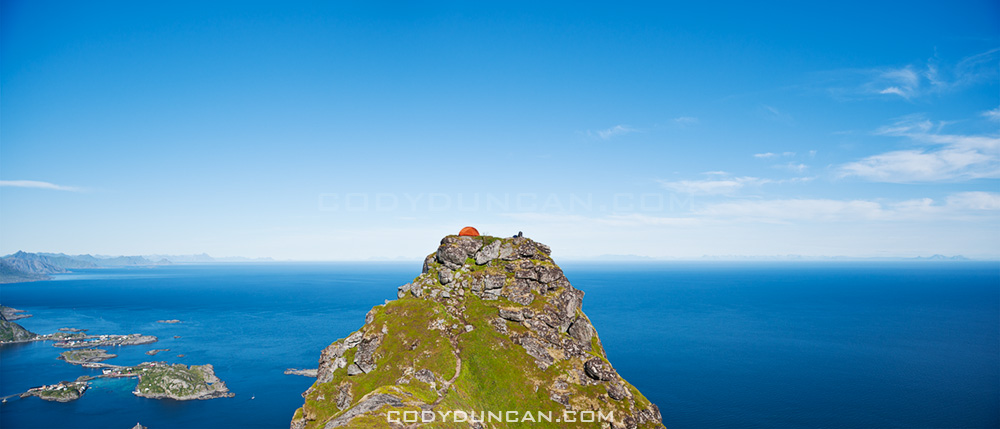
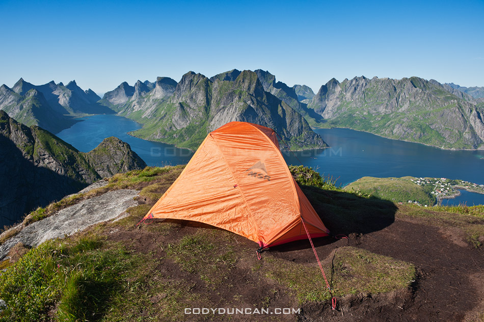
There are numerous suitable places for a tent (mostly dry and mostly flat) along the trail, with access to water generally not too far away.  The summit itself is quite flat and large with plenty of room as well.  Depending on the wind direction, several large rocks could provide some shelter from the weather, but as always, necessary caution should be taking if wishing to camp on an exposed summit.  No water available at the top.

Useful Links

Topo map: Search ‘Justadtinden.’

View from Justadtinden, Vestvagoy, Lofoten islands, Norway

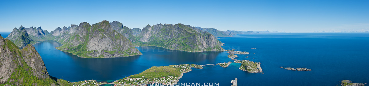
Photo: View from Justadtinden towards Himmeltindan

Lofoten islands winter

Photo: Justadtinden hidden behind Kangerurtinden in winter

Lofoten Islands Hikes – Reinebringen

Reinebringen Lofoten islands norway

Photo: Scenic view over Lofoten islands from summit of Reinebringen

Lofoten islands Hikes: Reinebringen

At a modest 448 meters high, Reinebringen is far from one of the highest peaks on the Lofoten islands.  Yet this is more than made up for by the spectacular view provided from the summit.  This view, combined with a relatively short hike and easy access from Reine means that Reinebringen is one of the most popular hikes on Lofoten.  It should definitely be near the top of ones travel plans while visiting the islands.  And if possible, saved for one of those elusive sunny days.

Directions
• By car:  Drive towards Reine. At the corner of the E10 and the turnoff into Reine is a parking area.  Alternatively, on the Å side of Ramsvikstunnelen are several small pullouts along the E10.

• By Bus: Take the bus to Reine.  You can ask the driver to let you off on the side of the E-10, before heading down into the village.

From Reine: walk west (south) along the E10 in the direction of Å.  Take the paved path along the outside of the tunnel (Ramsvikstunnelen).  Where the path is close to connecting back with the E10 on the far side, look for a small trail emerging from the bushes.  In summer it should be fairly simple to locate.

Reinebringen

The Hike

The trail begins as a somewhat muddy path winding its way upwards through low birch forest.  I managed to keep my feet dry wearing only trail runners, but it took a bit of extra care.  Climbing higher up the mountain, the trees begin to thin and and one will come across several short but wet rock steps to negotiate.  Once clear of the forest the trail gradually steepens and alternates between turf (which can be wet/slippery) and rocky sections.  Finally reaching the ridge, many stop here as the view is already quite stunning.  One can continue to the right up the steep rocks and follow the short trail to the last small peak.  Alternatively, one can follow the trail towards the left which continues high up the ridge.  3-4 hours, depending on fitness level, should be adequate for a round trip.

Reineibringen camping lofoten islands

Camping

There are several places along the ridge where a tent can be pitched.  All are completely exposed, so be aware of conditions and any incoming weather.  No water is available near the top, so be sure to bring enough.

Tent camping on Reinebringen mountain peak, Reine, Lofoten islands, Norway

Useful Links

Topo Map: enter ‘Reinebrinen’ in the search box

Lofoten Turlag

Images

Western Isles Scotland Photo Gallery

Storm over beach, Berneray, Scotland

Photo: Autumn storm passes over Sound of Harris, Berneray, Outer Hebrides, Scotland

SCOTLAND OUTER HEBRIDES PHOTO GALLERY: CLICK HERE

I’ve put up a image gallery from my Scottish islands trip at the end of October.  Photos from Isle of Harris, Isle of Lewis, Berneray, and North Uist.

Scenic Traigh Lar Beach, Isle of Harris

Scenic Traigh Lar Beach, Isle of Harris

Autumn

Autumn leaves in yard

I think it’s safe to say that autumn is my favorite time of the year.  Usually I would look forward to several trips to try and shoot the fall color.  Last year I was lucky to have pretty good timing for my travels in Sweden and Norway.  This year though, I haven’t been able to travel anywhere.  Well, that’s not totally true;  I was driving through Scotland the other week and the colors were absolutely brilliant, unfortunately it was raining like hell and I didn’t have the several days needed to wait until the weather cleared.  Here in Wales, there didn’t seem to be much color this year, and the winds of the last few days have blown off any leaves that still remained.  So my only autumn images of this year are from the backyard.  A bit disappointing…

First Snow

I was up hiking on Hay Bluff yesterday and saw the season’s first snow.  Ya, it’s not much, but Hay Bluff is quite low and it’s only the beginning of November. There was more to be seen on the other peaks in the Black Mountains and I heard the west coast of Scotland got a pretty good dumping, too bad I’m not up there at the moment. Hopefully this is a sign of what’s to come in the next months…

Callanish Standing Stones – Isle of Lewis

Callanish standing stones

Photo: Callanish standing stones, Isle of Lewis, Outer Hebrides, Scotland

The standing stones at Callanish are one of the more important sites in Scotland.  These image are from the main stone circle, but there are also several other smaller circles within view from this location.  And although I’ve done my best to make the location look isolated, in reality there is a village and houses just a 100 meters away.  Kind of takes away a bit of the mystery of a place like this.  For me it is some ancient place out of the long forgotten past.  In my mind it would be better located off in some distant boggy moorland with nothing else around.  For the locals of the village, it’s just a place they walk their dogs through.  The other stones at Callanish are just in the middle of sheep and cow pasture.

Anyhow, even though the stones have been photographed a million + times, they where still one of the locations I wanted to visit on my island trip.  I first stopped by in mid afternoon and got lucky with some blue sky and sun.  next I returned just prior to sunset and again was lucky and had about 10 minutes of sun before it disappeared behind the clouds.  I waited a bit into the night and was again lucky with the rising full moon.  I got a bit bored, and cold, waiting around for the sky to darken so I pulled out my flash and decided to play around a bit.  I must have looked like a complete mad man, running around the stones in the dark, popping off my flash at apparently random times, then running back to my camera.  Luckily I was the only one around by this point.

Callanish standing stones, Isle of Lewis, Outer Hebrides, Scotland

Evening sky over Callanish standing stones, Isle of Lewis, Outer Hebrides, Scotland

Callanish standing stones

Silhouette of Callanish standing stones, Isle of Lewis, Outer Hebrides, Scotland

Western Isles

callanish stones, isle of lewis, scotland

Photo: Autumn moonrise, Callanish standing stones, Isle of Lewis, Scotland

I’ve just returned from a week out on the islands of the Outer Hebrides off the west coast of Scotland.  I took the ferry from Uig on the Isle of Skye out to Tarbert on the Isle of Harris.  Then I traveled north to the Isle of Lewis, which is still part of the same island as Harris, for a couple nights.  After that I took the ferry down to Berneray and traveled the islands of North and South Uist and Benebecula.  Unfortunately, the first two days where the only ones of good weather, the rest of the trip consisted of heavy rain and strong winds. Still managed a few photos here and there…

My last visit to the islands was in 2003, and then I was only on Lewis and without a car, so most of the trip was new territory for me.  As a whole the islands are amazingly scenic, with everything from vast empty white sand beaches to rugged mountains and the worst bog that I’ve ever seen in my life.  I look forward to returning again in the not too distant future.

Traigh Rosamol Beach, Isle of Harris, Scotland

Photo: Dawn light on Traigh Rosamol Beach, Isle of Harris, Scotland