Best Photos of 2010 Part II

…Continuing on from my last post: Best Photos of 2010 Part I: January – June.  Here are what I feel my best photo’s from the second half of the year are.  The peak of this was my July-August trip to Norway’s Lofoten islands and Jotunheimen national park.  Otherwise, a week in Scotland at the end of October was really the only other productive period of photography for me.

Stamsund lofoten islands norway

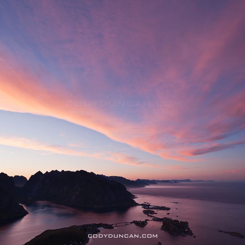
July: Summer twilight over Vestfjorden, Stamsund, Lofoten islands, Norway

The second appearance from the Lofoten islands on this list.  While the islands are more commonly pictured as jagged mountains rising from the sea, I feel this image helps portray some other aspects of islands: the sea, the light, the silence.  Only towards the end of July does the summer sun leave the sky, yet the night still remains a few weeks away.  This leaves an ever lengthening period of twilight as the sun travels further below the horizon.  It is during this time when the magical light of the north occurs.

This images was from a calm night, just a short walk out to the coast from the wonderful hostel at Stamsund.  I’ve stood in this exact same spot a dozen times, and walked away with a dozen different photos.  If I’m lucky, I’ll return again and again until I’m an old man.

Click here to view the entire photo gallery from my Lofoten Islands summer trip.

Memurudalen and mountains of Jotunheimen national park, Norway

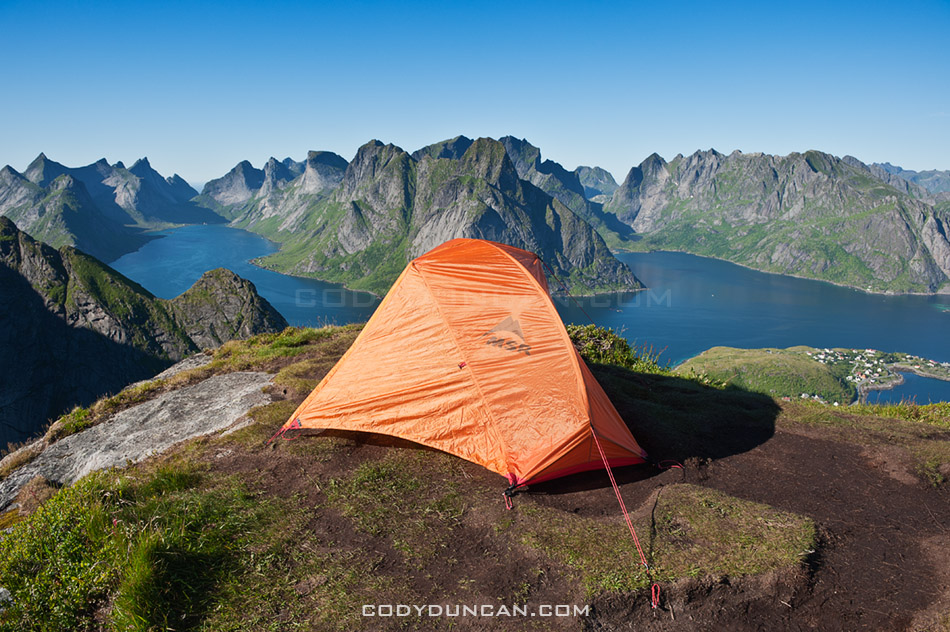
August: Memurudalen and Muru river, Jotunheimen national park, Norway

This was the view only a short walk from my tent in Norway’s Jotunheimen national park.  The weather was good this day, so I stopped here hoping this view would provide something spectacular for sunset.  Increasing clouds throughout the day led to a dance of shadows across the land.  While the sunset I was hoping for never arrived, I feel this image is an adequate representation of the brilliance of this location.  Another place that I’ll have to return to in the future.

Click here to view the rest of my images from Jotunheimen national park.

Fan Brycheiniog and Black Mountain, Brecon Beacons national park, Wales

September:  Black mountain, Brecon Beacons national park, Wales

I wont lie, this is more of a filler photo from an unproductive month.  It was a nice autumn day out hiking the the Black Mountain, but that’s about it.

Callanish standing stones, Isle of Lewis, Outer Hebrides, Scotland

October:  Callanish standing stones, Isle of Lewis, Scotland

In late October I found myself out on the Scotland’s Western Isles.  I had originally intended to travel here last year, but as normal, plans changed.  I got lucky when I arrived at the Callanish standing stones in the late afternoon with clear skies and calm wind, about as good of conditions as can be hoped for out there.  This photo is just a simple silhouette, yet for some reason it jumps out at me.

Click here to view photos from my Western Isles trip.

Corn Du brecon beacons

November:  Pen Y Fan and Corn Du, Brecon Beacons national park, Wales

I was a bit torn as to what to add here as late November brought a deep freeze to the UK, but I thought this image of the last day of autumn (before the snow) just had some magical light.  Typical Welsh weather of clouds, sun and shadows while hiking around Pen Y Fan in the central Brecon Beacons mountains.

Ice covers Llangorse lake at dawn, Brecon Beacons naitonal park, Wales

December: Winter ice covers Llangorse lake, Brecon Beacons national park, Wales

Llangorse is the only sizeable lake in the nearby area.  Despite this, the beginning of December was the first time I’ve ever been there.  And that is mostly because the roads have been too bad to go anywhere else.  For some reason I became slightly obsessed with getting a proper frozen lake image.    On my first visit I fell through some ice and had to leave early before any decent light.  With my second time I was greeted with impenetrable fog.  Finally on my third visit I had some clear skies, though the light is nothing special.  The surface of the lake is a bit messier than I would prefer, but at least the broken pieces of ice add some interesting shapes to the image.

Part I January – June: CLICK HERE

Best Photos of 2010 Part I

I’ve put together a list of what I think are my best image from each month of 2010.  That’s not to say these are all my best images of the year, as nearly all of them would have been from the Lofoten islands in January.  It’s been a good look at my consistency throughout the year.   There are definitely a few filler images from months where I wasn’t able to shoot much for whatever reason.   I’d say, April, June, and September are the weaker images of the year, Jan and July my favorites.

As a whole, it was an okay year photographically. I think I’ve captured some of my best images ever and had a couple productive trips.  But I’ve also felt a fair amount of frustration in being unable to realize a fair amount of my vision.  I guess I could say it better as: more often than not, I’ve failed to return with the images I wanted.  This is quite normal for landscape photography, but part of the problem is that I don’t want to be shooting landscape photography, I want to be shooting adventures and journeys surrounded by those landscapes.  Hopefully I’m able to find my vision better in 2011 and take my images to the level at which I want them to be…

Lofoten islands winter beach norway

January:  Arctic twilight on Haukland beach, Lofoten islands, Norway

This was a difficult month to pick only a single image from.  The 6 days I spent on the Lofoten islands at the beginning of the month were some of the most inspiring days I’ve ever had.  Jan 6th in particular, my first full day on the islands, was especially memorable and the light was simply amazing.  I was completely frozen after a chilly night sleeping in a wind rocked car.  When dawn arrived in mid morning, all was perfectly calm with a brilliant pink glow.  It was one of those days that I wished I could have been in 100 places at once; there were so many photos to be made, yet only a painfully few 4 hours of light of the arctic winter day.

This image is from Haukland beach and the first place I stopped in the morning.  It was nearly perfectly still, only the gentle waves that seemed more like a lake than ocean disturbed the silence.  While several images from this location could easily be my favourite images, I think this is the best.  For me the single piece of ice helps show the isolation of the frozen beach and lets the cold reach out to the viewer.  I only stopped shooting at this location when I wasn’t able to feel my feet for some 30 and decided I should try and warm up a bit.  My only critique is the otter tracks that pass through the image.

Lofoten islands winter: Click here to view gallery

Devils racetrack death valley

February:  Night on the Devil’s Racetrack, Death Valley national park, California

Another difficult month to choose from, mostly due to a fairly productive trip to Death Valley towards the end of the month.  After having spent the autumn and early winter in Scandinavia and the UK, I was in need for a bit of a change in scenery.  So I headed out to explore some parts of Death Valley national park that I’ve never been to before.

This image is from the Devil’s Racetrack, more commonly know as the location with the moving rocks.  Unfortunately, the above average winter rains had flooded the southern part of the lake where the rocks are, leaving it impassible due to the danger of leaving permanent damage to the fragile area.  Fortunately the northern half of the playa was dry and walkable.  A bit bored, with my planned shooting location off limits, I thought I’d just go lay down in the middle of the lake.  It was quite amazing really, all alone in the middle of nowhere, full moon overhead, cold night temperatures of winter desert, some AM talk station coming out of the radio.  I stayed out there shooting late into the night.

Abandoned walkay in water, Salton Sea, California

March:  Abandoned dock, Salton Sea, California

My last journey to the Salton Sea was in 2005, or was it 2004? Can’t remember at the moment.  Anyhow, in March, before temperatures became unbearably hot for me, I headed down.  I had been to this location on my last trip, so as I arrived in the dark of early morning I thought I knew where I would be.  How I was wrong.  The sea level was now far lower and the shore nowhere near as I remembered.  Anyhow, as I explored a bit, I found this cool old dock just as the first light of the sun was arriving.

Burnt tree in Mojave national preserve, California

April: Charred tree, Mid Hills Campground, Mojave national preserve, California

In 2005, lightning strikes started the Hackberry fire which swept thought the high desert area of the Mojave national preserve.  On the first night of a 4WD trip of the Old Mojave Road, we camped at the Mid Hills campground which was partially burned.  I’d never been to this area, nor heard about the fire, so It was quite interesting to see a charred desert landscape.

Mt whitney tent

May: View from tent towards east face of Mt. Whitney, Sierra Nevada Mountains, California

Nearly five years to the day of my last trip up Mt. Whitney, I found myself looking at the mountain again.  It was sort of a last minute trip, but everything worked out and I made a successful climb of the mountain.  This is the view from my camp at Iceberg lake towards the east face and Mountaineers route of Mt. Whitney.

Brecon Beacons wales

June:  Stormy weather over Black Mountain, Brecon Beacons national park, Wales

Black Mountain is the westernmost range of Brecon Beacons national park.  Just an image from a less-than-sunny day wandering among the mountains.

Part II July – December: CLICK HERE

Lofoten Islands Hikes – Justadtinden

Justadtind lofoten islands

Photo: Justadtinden rises in the distance

Lofoten Islands Mountain Hikes: Justadtinden

Justadtinden (738 meters) is the highest peak on the eastern side of Vestvågøya.  An easy and well worn trail through a scenic mountain landscape makes reaching the summit of Justadtinden a relatively easy hike and a good first introduction to the Lofoten islands.  While the summit itself is rather flat and slightly anticlimactic, the 360º view is still something impressive.  When the sun is out and the winds are calm, I imagine this would be a nice place for a picnic on a summer afternoon.

Photo: Winter view from Stamsundsheia. Justadtinden (738 meters) is flat summit on left, Kangerurtinden (704 meters) on right

Getting There

By Car: From north or south, take the E10 to Leknes.  From Leknes, take the 815 towards Stamsund.  After approximately 4km the road rises to the pass at Hagskaret (Where the large building is).  There are two parking options here on the left side of the road (before the building), one paved, one dirt.

From the parking area, take the dirt road towards the large antenna visible a couple hundred meters to the north.  Keep following the road straight.  After passing the antenna building on the right (don’t turn here), the road will soon end and turn into a hiking trail.  There are several trails that cross back and forth, keep in the general direction of the right (east).

Photo: Mountain landscape near Justadtinden

The Trail
From the start of the trail, the summit of Justadtind is approximately 6km away, with 600 meters of elevation gain.  The first half of the trail gently gains elevation while wandering through low hills and ridges.  The second half of the trail gradually increases in steepness (though still quite a gentle grade) and passes through a section of rocks shortly before the summit.  The rocky outcropping that appears as the highest point in the top.

Photo: View from summit of Justadtinden towards Henningsvaer

Camping

There are numerous suitable places for a tent (mostly dry and mostly flat) along the trail, with access to water generally not too far away.  The summit itself is quite flat and large with plenty of room as well.  Depending on the wind direction, several large rocks could provide some shelter from the weather, but as always, necessary caution should be taking if wishing to camp on an exposed summit.  No water available at the top.

Useful Links

Topo map: Search ‘Justadtinden.’

View from Justadtinden, Vestvagoy, Lofoten islands, Norway

Photo: View from Justadtinden towards Himmeltindan

Lofoten islands winter

Photo: Justadtinden hidden behind Kangerurtinden in winter

Lofoten Islands Hikes – Reinebringen

Reinebringen Lofoten islands norway

Photo: Scenic view over Lofoten islands from summit of Reinebringen

Lofoten islands Hikes: Reinebringen

At a modest 448 meters high, Reinebringen is far from one of the highest peaks on the Lofoten islands.  Yet this is more than made up for by the spectacular view provided from the summit.  This view, combined with a relatively short hike and easy access from Reine means that Reinebringen is one of the most popular hikes on Lofoten.  It should definitely be near the top of ones travel plans while visiting the islands.  And if possible, saved for one of those elusive sunny days.

Directions
• By car:  Drive towards Reine. At the corner of the E10 and the turnoff into Reine is a parking area.  Alternatively, on the Å side of Ramsvikstunnelen are several small pullouts along the E10.

• By Bus: Take the bus to Reine.  You can ask the driver to let you off on the side of the E-10, before heading down into the village.

From Reine: walk west (south) along the E10 in the direction of Å.  Take the paved path along the outside of the tunnel (Ramsvikstunnelen).  Where the path is close to connecting back with the E10 on the far side, look for a small trail emerging from the bushes.  In summer it should be fairly simple to locate.

Reinebringen

The Hike

The trail begins as a somewhat muddy path winding its way upwards through low birch forest.  I managed to keep my feet dry wearing only trail runners, but it took a bit of extra care.  Climbing higher up the mountain, the trees begin to thin and and one will come across several short but wet rock steps to negotiate.  Once clear of the forest the trail gradually steepens and alternates between turf (which can be wet/slippery) and rocky sections.  Finally reaching the ridge, many stop here as the view is already quite stunning.  One can continue to the right up the steep rocks and follow the short trail to the last small peak.  Alternatively, one can follow the trail towards the left which continues high up the ridge.  3-4 hours, depending on fitness level, should be adequate for a round trip.

Reineibringen camping lofoten islands

Camping

There are several places along the ridge where a tent can be pitched.  All are completely exposed, so be aware of conditions and any incoming weather.  No water is available near the top, so be sure to bring enough.

Tent camping on Reinebringen mountain peak, Reine, Lofoten islands, Norway

Useful Links

Topo Map: enter ‘Reinebrinen’ in the search box

Lofoten Turlag

Images

Bunes Beach Camping – Lofoten Islands

Bunes Beach panoramic photo, Lofoten islands, Norway

Photo: Panoramic view of Bunes beach, Lofoten islands, Norway

Bunes Beach, Moskenesøya, Lofoten Islands, Norway

Bunes is one of the more scenic and isolated beaches on the Lofoten Islands.  Though unfortunately this isolation does not always mean the beach is uncrowded.  On a sunny summer day thick crowds of tourists will be waiting on the pier in Reine to catch the morning ferry over for the day. However, as afternoon approaches the crowds begin the walk back over the pass on their return to civilization.  Now the beach becomes empty and quiet, likely only a few groups of campers will remain and have the place to themselves.  Time is irrelevant in summer anyhow.  The sun will shine until late in the night when it finally passes behind the mountains to the north.

The beach is larger than it first appears.  From the end of the trail to the water is around 600-650 meters, while the beach is 750 meters across.  High, glacially carved cliffs surround the beach, the massive 602 meter west face of Helvetestinden being the most impressive.  The beach faces north-west and is a good place to catch a sunset from late summer to early autumn. Wander out to the cliffs on the left, past the single house, for the best view.  Storms can unfortunately leave sections of the beach rather covered in debris, particularly towards the back. Though on the bright side, a ready supply of driftwood can be found for evening campfires.

Neutral Density long exposure, Bunes beach, Moskenesoy, Lofoten islands, Norway

Photo: Daytime long exposure with 10 stop neutral density filter, Bunes beach, Lofoten islands, Norway

Neutral Density long exposure, Bunes beach, Moskenesoy, Lofoten islands, Norway

Photo: Daytime long exposure with 10 stop neutral density filter, Bunes beach, Lofoten islands, Norway

Bunes Beach Lofoten islands

camping at Bunes Beach, Lofoten islands, Norway

Photo: Summer camping at Bunes beach, Lofoten islands, Norway

Camping
The best camping is on the flat grassy dunes found at the back of the beach.  The area is large so even if some other groups are present, there is no feeling of crowding.  No supplies are available in Vindstad, so be sure to bring everything you would need for typical wilderness camping.  Fresh water can be collected via several waterfalls towards the back-left side of the beach.  A door-less drop toilet is on the side of the trail just before reaching the beach.

A note of caution should be made to the weather. The beach and camping areas are completely exposed to the north-west and any weather which my come from there.  And once the afternoon ferry leaves you are stuck there until the following morning, so be sure to check the forecast for the following days if planning on camping.  If bad weather does arrive, there are several large boulders on the Vindstad side of the pass that have enough room for 1-2 tents and should provide enough shelter from the wind, depending on the direction.

camping at Bunes Beach, Lofoten islands, Norway

Photo: Afternoon nap in the sun, Bunes beach, Lofoten islands, Norway

camping at Bunes Beach, Lofoten islands, Norway

Photo: Sunny summer afternoon at camp, Bunes beach, Lofoten islands, Norway

Bunes Beach, Lofoten islands, Norway

Photo: Toilet with a view, Bunes beach, Lofoten islands, Norway

Getting There
The easiest approach is to take the Ferry from Reine to the village of Vindstad.  From there follow the easy path through the village and towards the back of the Fjord.  After about 2 km the village will end at there will be a small trail on the left.  This should be marked with a sign saying ‘Bunes,’ or something thereabouts.  An easy and well worn trail leads over the small pass and down onto the beach.  Be sure to measure how long you’ll need to get back to catch the ferry on time, but 1 hr should be plenty for most people.

The ferry time schedule can be found here: CLICK HERE

Reine ferry boat in Fjord, Lofoten islands

Photo: Reine ferry arriving to pick up passengers in Vindstad

Reine ferry directions

Photo: Reine, showing locations of bus stop and Ferry port

Nidaros Cathedral

Nidaros Cathedral, Trondheim, Norway

Nidaros Cathedral, Trondheim, Norway.

I had 1.5 days to wander around Trondheim at the end of my Norway trip back in August.  Luckily I had some nice sunny weather as I wandered around the streets.

Nidaros Cathedral river reflection, Trondheim, Norway

Jotunheimen National Park Photogallery

Scenic mountain landscape of Jotunheimen national park, Norway

Photo: Wild camping in Jotunheimen national park, Norway

Jotunheimen National Park, Norway photogallery: CLICK HERE

I was quite lucky with my timing in Jotunheimen.  The rain cleared after the first night and I had pleasant weather until I was getting on the bus to Trondheim several days later and the rain once again returned.

Lake Gjende and Besseggen ridge, Jotunheimen national park, Norway

Photo: Colorful lake Gjende as seen from Besseggen ridge, Jotunheimen national park, Norway

68 North Website update

lofoten islands landscape photography

Photo:  Mountain peak rises from sea, Stamsund, Lofoten islands, Norway

I’ve added a new photo gallery to 68north.com of my Lofoten photos from July/August.  CLICK HERE

Lofoten Light

Reinebringen – Lofoten islands

Lofoten islands sunset from Reinebringen

Photo: Sunset over mountains of Lofoten islands viewed from Reinebringen.

Kjerkfjord mountain sunset from Reinebringen

Photo: Rays of sun shine from behind mountain peaks, viewed from Reinebringen, Lofoten islands, Norway.