Lofoten Islands Hikes – Reinebringen

Reinebringen Lofoten islands norway

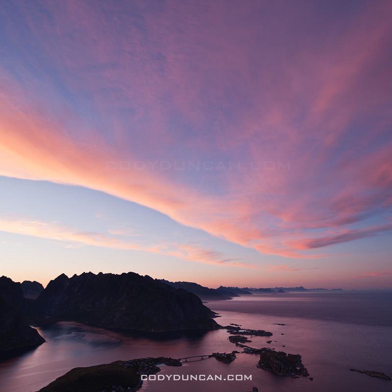
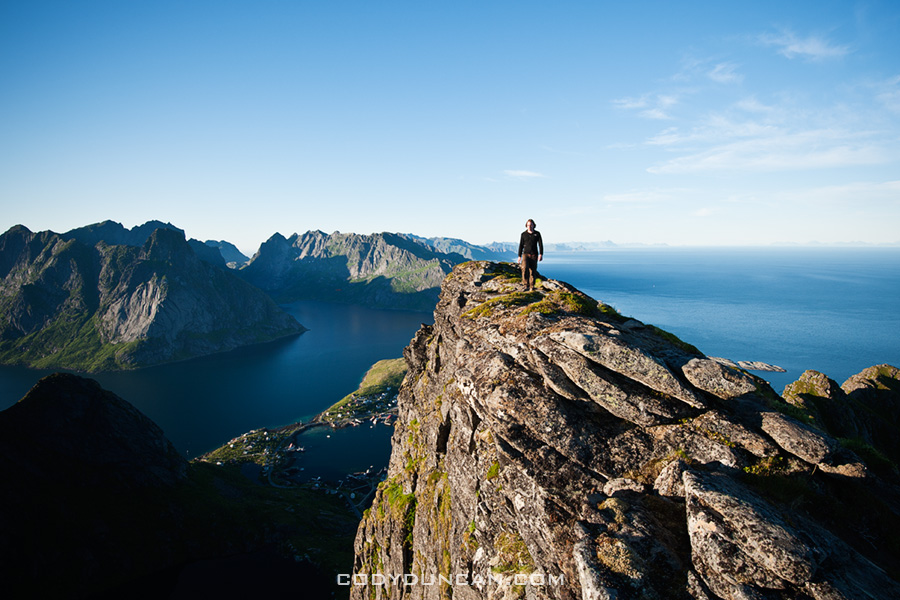
Photo: Scenic view over Lofoten islands from summit of Reinebringen

Lofoten islands Hikes: Reinebringen

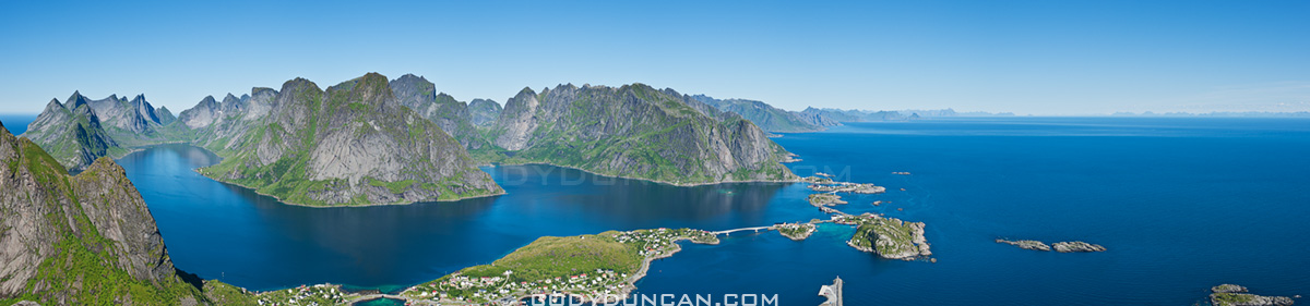
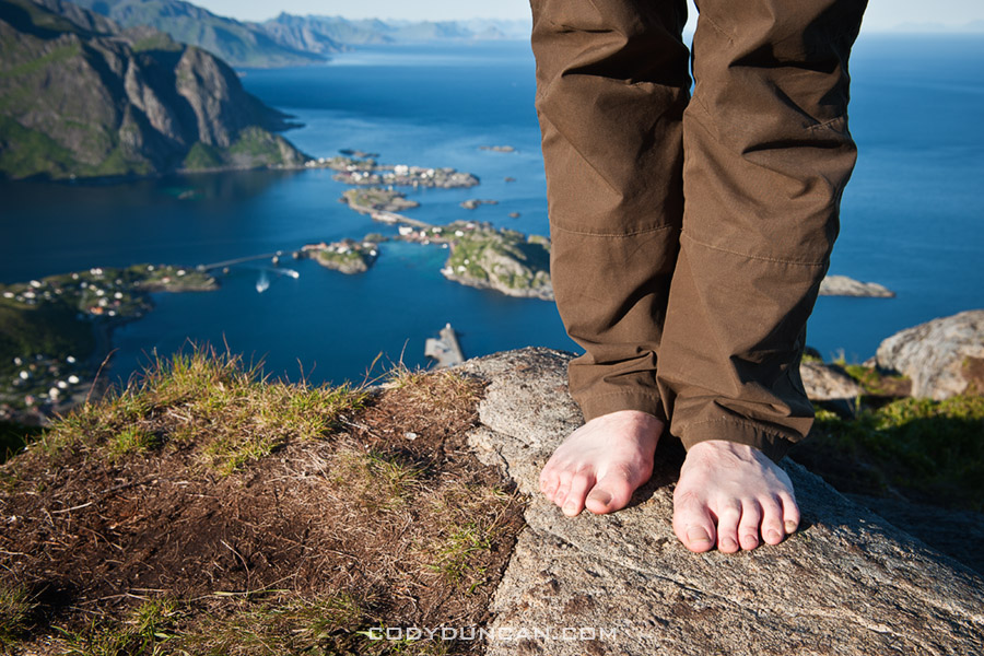
At a modest 448 meters high, Reinebringen is far from one of the highest peaks on the Lofoten islands.  Yet this is more than made up for by the spectacular view provided from the summit.  This view, combined with a relatively short hike and easy access from Reine means that Reinebringen is one of the most popular hikes on Lofoten.  It should definitely be near the top of ones travel plans while visiting the islands.  And if possible, saved for one of those elusive sunny days.

Directions
• By car:  Drive towards Reine. At the corner of the E10 and the turnoff into Reine is a parking area.  Alternatively, on the Å side of Ramsvikstunnelen are several small pullouts along the E10.

• By Bus: Take the bus to Reine.  You can ask the driver to let you off on the side of the E-10, before heading down into the village.

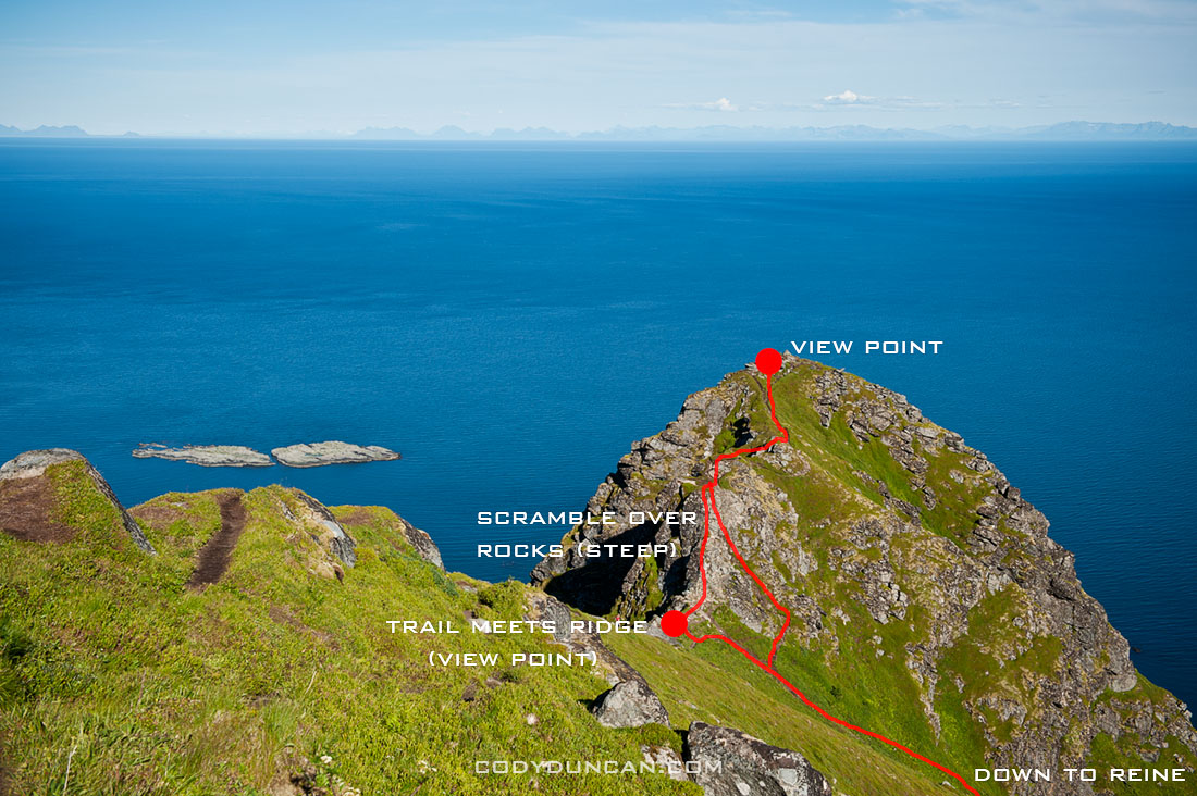
From Reine: walk west (south) along the E10 in the direction of Å.  Take the paved path along the outside of the tunnel (Ramsvikstunnelen).  Where the path is close to connecting back with the E10 on the far side, look for a small trail emerging from the bushes.  In summer it should be fairly simple to locate.

Reinebringen

The Hike

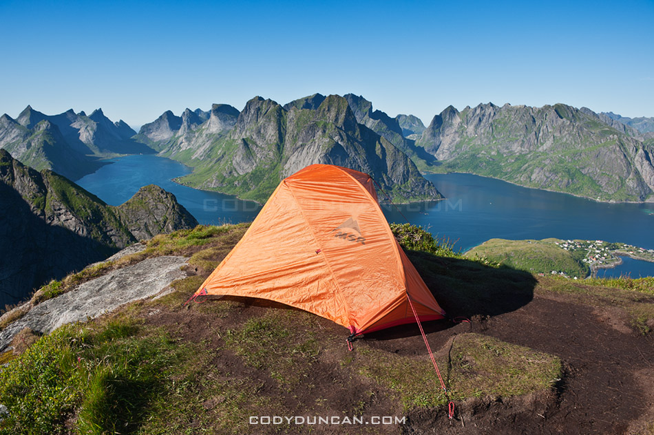
The trail begins as a somewhat muddy path winding its way upwards through low birch forest.  I managed to keep my feet dry wearing only trail runners, but it took a bit of extra care.  Climbing higher up the mountain, the trees begin to thin and and one will come across several short but wet rock steps to negotiate.  Once clear of the forest the trail gradually steepens and alternates between turf (which can be wet/slippery) and rocky sections.  Finally reaching the ridge, many stop here as the view is already quite stunning.  One can continue to the right up the steep rocks and follow the short trail to the last small peak.  Alternatively, one can follow the trail towards the left which continues high up the ridge.  3-4 hours, depending on fitness level, should be adequate for a round trip.

Reineibringen camping lofoten islands

Camping

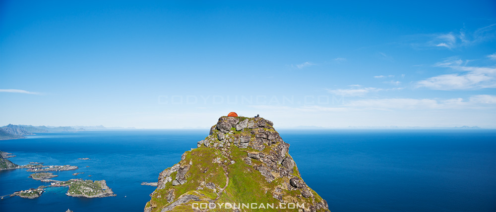
There are several places along the ridge where a tent can be pitched.  All are completely exposed, so be aware of conditions and any incoming weather.  No water is available near the top, so be sure to bring enough.

Tent camping on Reinebringen mountain peak, Reine, Lofoten islands, Norway

Useful Links

Topo Map: enter ‘Reinebrinen’ in the search box

Lofoten Turlag

Images

Jotunheimen National Park Photogallery

Scenic mountain landscape of Jotunheimen national park, Norway

Photo: Wild camping in Jotunheimen national park, Norway

Jotunheimen National Park, Norway photogallery: CLICK HERE

I was quite lucky with my timing in Jotunheimen.  The rain cleared after the first night and I had pleasant weather until I was getting on the bus to Trondheim several days later and the rain once again returned.

Lake Gjende and Besseggen ridge, Jotunheimen national park, Norway

Photo: Colorful lake Gjende as seen from Besseggen ridge, Jotunheimen national park, Norway

Reinebringen – Lofoten islands

Lofoten islands sunset from Reinebringen

Photo: Sunset over mountains of Lofoten islands viewed from Reinebringen.

Kjerkfjord mountain sunset from Reinebringen

Photo: Rays of sun shine from behind mountain peaks, viewed from Reinebringen, Lofoten islands, Norway.

Lofoten Islands – Reinebringen Summer Day

view from Reinebringen, Lofoten islands, Norway

The view from Reinebringen is one of the classic views of the Lofoten islands.  A good weather forecast along with plenty of luck would find me hiking up the mountain on a perfectly calm and cloudless Sunday afternoon, probably the best day of the 2 weeks I was on the islands.  The only drawback was that I had just more that a half liter of water which would have to last me some 20 hours and the hike back down to Reine the following morning.

Scenic view of Reine from Reinebringen peak, Lofoten islands, Norway

Tent on Reinebringen, Lofoten islands, Norway

My tent setup on to the mountain.  I later took the tent down and just slept out in the open, but during the day this was the only source of shade until sunset at around 11:30 at night.  I think it made for some good photos though.

Tent camping on Reinebringen mountain peak, Reine, Lofoten islands, Norway

Memurudalen – Jotunheimen national park

Memurudalen panoramic landscape, Jotunheimen national park, Norway

Photo: Memurudalen panoramic, Jotunheimen national park, Norway

Memurudalen (say that 10 times) is a scenic alpine valley that ends on the northern side of lake Gjende.  The northern end of the valley rises into glaciers and mountains, from where the fast and cold Muru river flows.

Memurudalen and mountains of Jotunheimen national park, Norway

Photo: Surtninssue rises above Memurudalen, Jotunheimen national park, Norway

wild camping Jotunheimen national park, Norway

Photo: Wild camp above Memurudalen, Jotunheimen national park, Norway

Muru river in Memurudalen, Jotunheimen national park, Norway

Photo: Cold glacial melt water of the Muru river flows through Memurudalen, Jotunheimen national park, Norway

Norway | Lofoten Islands and Jotunheimen National Park

Evening twilight light in summer over sea, Stamsund, Lofoten islands, Norway

Photo: Summer twilight over Vestfjord at midnight, Stamsund, Lofoten islands, Norway

Evening light on scenic coastline, Stamsund, Vestvagoy, Lofoten islands, Norway

Photo: 1:30 AM summer twilight, Stamsund, Lofoten islands, Norway

From the end of July to the middle of August I was over in Norway.  First two weeks were on the Lofoten Islands waiting out mostly bad weather for an elusive sun.  The third week I was hiking among the mountains and lakes of Jotunheimen national park, where I was lucky and had lots of sun.  All in all, it was a pretty productive trip.

That’s all for now (figured I needed to post something after 3 weeks of silence…).  I’ll try and keep a more regular flow of images and words in the next weeks.

Lake Gjende Jotunheimen national park, Norway

Photo: Lake Gjende from above Memurubu, Jotunheimen national park, Norway

Reflection on lake Gjende, Gjendesheim, Jotunheimen national park, Norway

Photo: Lake Gjende from Gjendesheim, Jotunheimen national park, Norway

Twmpa – Black Mountains, Wales

Welsh landscape photography - Twmpa, Black mountains, Wales

Twmpa, also known as Lord Hereford’s knob, is a somewhat prominent looking, but fairly low peak in the northern part of the Black mountains, Brecon Beacons national park, Wales

Twmpa and welsh countryside, Brecon Beacons national park, Wales

Norwegian Hiking and Backpacking

Summer Wild Camping and Backpacking, Jotunheimen, Norway

Photo: Camping above lake Bygdin, Jotunheimen national park, Norway

Jotunheimen glaciers and mountains, Norway

Photo: Cloudy skies over mountains and glaciers in Jotunheimen national park, Norway.

To put it nicely, Norway is not a ‘sunny’ country.  Don’t be fooled by travel guides and brochures showing photos scenic green meadows, waterfalls, or fjords with calm puffy white clouds and blue skies overhead on every page.  This is a lie.  I can’t count how many times I’ve set my tent up in the rain only to take it down in the rain on the following morning, for days on end.  Even during the height of summer one should always be prepared for cold, wet, and windy conditions.  This applies even more if one is planning on venturing out in the mountains.

Camping Kvalvike beach, Lofoten Islands, Norway

Photo: Camping at Kvalvike beach, Lofoten islands, Norway.

So if the weather sucks so bad, why even go?  Because Norway is an amazingly beautiful and friendly country.  And because when that sunny summer day does come, you will instantly forget that week of rain and cloud that proceeded and will follow it.  And if you are north of the arctic circle and standing on a mountain top at 2 am under a perfectly blue sky, you will already start planning your return trip.

Mountain lunch, Lofoten islands, Norway

Photo: Mountain snack, above Stamsund, Lofoten islands, Norway

Here’s my packing list for a 3 week trip which I start tomorrow.  The first 2 weeks I’ll out on the Lofoten islands, followed by one week hiking around Jotunheimen national park.  Since the main purpose of my trip is photography, I need to keep the weight of my camping equipment and clothing to a minimum to help offset the weight of my camera gear.

Some useful links for traveling around Norway:

Backpacking packlist for Norway

Footwear:
I normally only wear hiking boots in places where I’ll encounter lots of snow and or bog/mud, such as Norway.  However, I’m trying to keep things a bit lighter on this trip so I’m only going to take some trail-runners.  This may be a regrettable decision and lead to constantly wet feet, but I hope not…

Camping Gear:
•Backpack – Golite Odyssey
•Daypack/camera bag – Black Diamond Sphynx 32L
•Tent – MSR Hubba single person
•Sleeping Bag – Mountain Hardwear Phantom 32
•Lightweight foam sleeping pad
•Leki Makalu trekking poles
•Water filter – Katadyn mini
•Petzl Zipka plus headlamp
•first aid kit
•Rain cover for backpack

Cooking:
•Stove – Snow Peak GigaPower
•Cookware – Snow Peak titanium pan & lid
•Spoon Fork combination
•Food

Misc:
•Multipurpose camp soap
•journal & pens
•Hand cleaner
•Plug adapter
•Book
•Maps

Clothing:

•Shell Jacket – Golite
•Shell Pants – Marmot Precip
•Marmot Driclime windshirt
•Lightweight fleece
•MEC lightweight softshell pants
•Lightweight shorts
•3x t-shirts
•3x socks
•3x underwear
•Fleece beanie
•Lightweight camp towel
•Sandals

Lake Gjende in summer, Jotunehimen, Norway

Photo: Scenic summer view of Lake Gjende, Jotunheimen national park, Norway.

Wales – Black Mountain

Black Mountain Landscape, Brecon beacons national park, Wales

Black Mountain (yes, singular, not plural) is the name of the westernmost range of the Brecon Beacons national park.  The other two being the Black mountains (plural this time) in the east and along the English border.  While the Brecon Beacons range, from where the national park takes its name and home to the highest mountain in south Wales (Pen Y Fan), sits between the two ‘black’ ranges.

Access into the Black mountain is about an hour from here, so I’ve only just begun to explore the area in the last weeks.  They are much more rugged and isolated that the Black MountainS here in my backyard, so I’m looking forward to spending more time out there.  There is also a roughly 100 mile long trail called the Beacons Way which runs east to west across the park which has also caught my attention for some time in the future.

Black Mountain Landscape, Brecon beacons national park, Wales

Black Mountain Landscape, Brecon beacons national park, Wales

Buachaille Etive Mor

Buachaille Etive Mor, Scotland

Buachaille Etive Mor.

Probably one of the most iconic, and therefore, most photographed scenes from the Scottish Highlands.  A cold December morning last year.