10 years

Lofoten islands, Norway

Photo: Boats at rest in Ågvatnet, Å I Lofoten, Norway.  2001

I know the above photo kind of sucks.  I shot it 10 years ago within a couple hours of stepping foot on Lofoten for the first time.  It’s taken with an old Nikon FE and a crappy 35-105mm lens on Fuji Provia 100, hand held sometime shortly before midnight.  I made a print of it, where it hung on my wall for 5 years before I was able to return again.  Over the years I’ve tried to take a ‘better’ version of this photo, but I’ve never encountered proper conditions.  Despite all its faults, it’s still one of my favorites.  I can remember those moments with stunning clarity; it was the point where I knew I had ended up someplace special.  With luck and hard work, Lofoten will be my home by the end of the year.  Something I’ve dreamed about all those years, yet never managed to make much progress towards.  Maybe I just needed to get a little older.

stamsund

Lofoten Islands Hiking – Steinetinden

steinetinden, stamsund lofoten islands norway

Photo: Winter view from Stamsundheia towards Steinetinden in distance.  Mar 2009

Steinetinden (sometimes called Steinstind, Steinstinden) is a relatively small 509 meter high peak located between Stamsund and Steine on Vestvågøy in the Lofoten islands.  By Lofoten standards its not anything spectacular.  The main attraction of the peak is its close location to the Stamsund youth hostel, about a 5 minute walk across the street for the beginning of the trail.  If you have access to a car, I would recommend setting you’re sights on more aesthetic peaks.  If you just got off the Hurtigruten in Stamsund, are lucky enough to have some fair weather, then Steinetinden is the perfect introduction to what the Lofoten Islands have to offer.  The views aren’t bad, just not as good as elsewhere on the islands.

Location:
Steinetinden is the highest peak along the circular mountain ridge towards the east of Stamsund.  The most direct and straight forward way is walk up ‘Ringveien’ street which is located across from the Joker market.  From Ringveien one has several options.  One way is to turn on Halsbakken street and continue walking east towards the mountain.  When you see a yellow house with what looks like a parking area  for 2-3 cars in the street before it, head into the bushes at the back of the parking area.  You should detect a faint and probably overgrown trail.  This way will take you up and over Mannfallet first.

Otherwise, from Ringveien take the pathway into the forest at the back of the road that heads towards the lakes (this is also the cross-country ski route in winter).  After several hundred meters on the trail, there should be a sign and a small trail coming from the left.  Once on this trail, there are also two options when one comes to the fork.  Towards the left takes one up the middle peak of Mannfallet (308 meters), towards the right the trail continues through the forest and up a steep, often muddy trail towards Steinetinden.  Personally I think hiking up Mannfallet first is the more scenic route, and even slightly easier.  I generally save the steeper, more direct route for the way down, to make a bit of a loop out of things.

Whether going over Mannfallet first or heading direct towards Steinetinden you will eventually find yourself in a flat grassy area between the two peaks.  From here the trail steeply climbs about another 150 meters up to the summit of Steinetinden.

A word of caution:
while for the most part the trail is not anything technical, there are several locations where it passes quite close to high, steep cliffs and one is exposed to a possible fall of 400-500 meters.  In wet conditions the trail can also be quite slippery/muddy.  There are also several short rock steps that need to be negotiated, again with some exposure to a possible long fall. Go with a group of people if possible, and especially if you’re new to mountains.  Be sure to have proper footwear and don’t be afraid to turn around if necessary.

steinetinden, stamsund lofoten islands norway

Photo: Final climb towards summit.  July 2006

steinetinden, stamsund lofoten islands norway

Photo: Summer view from Manfallet towards Steinetinden.  July 2006


steinetinden, stamsund lofoten islands norway

Photo: Spring view from Mannfallet towards Steinetinden.  April 2007

steinetinden, stamsund lofoten islands norway

Photo: A bit of exposure near the summit.  July 2006

steinetinden stamsund lofoten islands

Photo: View of Stamsund from summit. Aug 2010

map

Hadselfjorden – Norway

Hadselfjorden vesteralen norway

Photo: Autumn storms over mountains of Vesterålen while traveling on Hurtigruten ferry through Hadselfjorden, Norway. Sept 2009

I think Hadselfjorden is not really a fjord but a straight, separating some of the Vesterålen islands and a bit of Lofoten as well.  But in Norwegian, if its made of salt water, and you can see land from it, they call it a fjord. Forget about firths, bays, straights, bights, coves, channels, etc.  Fjord it is in Norway. (Yes, I know this is not totally true.  I’m attempting to be slightly humorous.  No need to correct me.)

I usually have pretty good luck with dramatic light and stormy weather while traveling along the Norwegian coast, making it one of my favorite ways to get up and down the country.  Maybe its just always stormy.  These images are from one autumn afternoon while traveling on the Hurtigruten from Sortland to Stamsund. 


Stormy seas of Hadselfjord, Vesteralen, Norway

Dramatic skies over rising mountain peaks of Vesteralen viewed from Hadselfjord, Norway

Steep mountains rise from sea, Lofoten islands, Norway

Dramatic light over mountains of vesteralen as viewed from Hurtigruten

Moonrise over Vestfjord

Full moon rising over Vestfjord, Stamsund, Lofoten islands, Norway

Photo: Full moon rises over Vestfjord on a calm autumn evening, Stamsund, Lofoten islands, Norway.  Oct 2009

The last month has been pretty slow for me so I’ve been processing some older stuff to send into my agencies.  Mostly its crap that I passed over for a reason, but I’ve found a few decent images here and there.  I think looking back on work after a year or two gives a different perspective than that of immediately after the trip.  Perhaps the separation of time means I look more at the image alone, without the added memories or emotions that may be associated with it.  Or maybe I was simply going for a particular look or theme immediately after a trip.  Whereas now I can look back and figure if its a halfway decent photo, I might as well see if my agency wants it.  Though I’m sure there are slightly more productive things that I should be doing, like writing a business plan that will hopefully allow me a work visa for Norway.


Panoramic Landscape Photography

Scenic winter view across Kjerkfjorden towards Vindstad, near Reine, Lofoten islands, Norway

Winter view across Kjerkfjorden towards Vindstad, Lofoten islands, Norway.  Jan 2010.  This was perhaps one of the most perfect days I’ve experienced in my life.  The day to which I have since judged every other; none having come close in the last 18 months since I took this photo.  But as with all good things, the 4 hours of light of the polar winter was gone all to quickly.  An amazing 4 hours it was.

I now have close to 600 images in my panoramic gallery.  CLICK HERE to view more.

Reflection on lake Gjende, Gjendesheim, Jotunheimen national park, Norway

Lake Gjende, Jotunheimen national park, Norway.  Aug 2010.  I rose early for sunrise, yet nothing of much interest materialized so I returned to my tent for a few more hours of rest.  A few ours later I peeked out the door and saw this scene of total calm.  I checked my watch, shit, the ferry leaves in a few minutes, time to get moving.  I hoped up, ran down barefooted (to the mosquitoes liking) to the shore of the lake.  5 minutes later, the morning ferry to Gjendesheim passes by, the wake leaving the lake rippled there after…

Dramatic light over Lofoten and Vesteralen islands, Norway

Lofoten and Vesteraalen islands, Norway.  Sept 2009.  Taken from on board the Hurtigruten ferry as I traveled from Sortland to Stamsund on a rather stormy and windy day.  Luckily storms and wind make for nice light is one is brave enough to face the elements.  I made many nice Photos during this journey.

Ring of Brodgar standing stones, Orkney, Scotland

Ring of Brodgar, Orkney, Scotland. Dec 2009.  The barren, windswept islands which make up the Orkney islands are one of my favorite places.  While the short days of December are probably not the most ideal time to visit, it had been three years since I last stepped foot here, so my return was long overdue.  Despite a bit of wind, the weather cooperated quite well over the few days I was there.

Welsh Mountain Pony

Welsh Mountain Pony, Hay Bluff, Brecon Beacons national park, Wales. Jun 2010.  Hay Bluff, just above the town of Hay-on-Wye was one of my favorite places for a summer afternoon of wandering around the hills.  Quite often the weather was typically ‘Welsh’ (rain), yet some days managed to turn out quite nice, there in a Welsh Mountain Pony, and there you go, the photo is almost made for you.

Stamsund, Lofoten islands Norway

Stamsund, Lofoten islands, Norway.  July 2010.  I’ve stood in this very spot a hundred times in the last 10 years, and walked away with a hundred different images.  It’s a little rocky point out beyond the harbor from the Stamsund Vandrerhjem.  To the north is this view towards Henningsvaer.  East looks across the Vestfjord towards the Norwegian mainland, visible on clear days.  This photo was taken after 11:00pm, on one of those magically endless Lofoten summer days.  Stamsund is quite simply the center of the universe, enter and you may never return…

Abandoned walkay in water, Salton Sea, California

Salton Sea, California.  Mar 2010.  The Salton Sea is always an interesting place, both for ones eyes and nose.  I arrived in darkness to a location that I thought I knew, yet I wasn’t aware just how far the lake level had declined since my last visit.  This is what I found waiting in the morning light.

Eureka dunes, Death Valley national park, California

Eureka Dunes, Death Valley national park, California. Feb 2011.  Isolated in the northern end of Death Valley national park are the Eureka Dunes.  Less frequented than other areas of the park, one can escape here for a bit more isolation and a better chance at footprint-less dunes.

Dry lake bed of the Racetrack playa, Death Valley national park, California

Devil’s Racetrack, Death Valley national park, California. Feb 2010.  Vertical panoramic to emphasize the texture of the dry lake bed playa.


Eggum – Lofoten

Eggum winter lofoten islands

Photo: Boat sheds in winter, Eggum, Lofoten islands, Norway. Jan 2010

In summer, with it’s north facing coastline, Eggum is a popular location for campers hoping to see the midnight sun. The grassy, green fields past the town are often filled with tents and RV’s enjoying the 24 hours of daylight during the Lofoten summer. After the road ends there is also a nice, easy coastal walk which connects to the village of Unstad.

In winter, Eggum is a lonely place. There is no light, and cold northern winds often sweep across the landscape.

Eggum winter lofoten islands

Photo: Empty windswept road, Eggum, Lofoten islands, Norway.  Jan 2010

Winter coastline at Eggum, Lofoten islands, Norway

Photo: Rocky coastline in winter, Eggum, Lofoten islands, Norway.  Jan 2010

Best Photos of 2010 Part II

…Continuing on from my last post: Best Photos of 2010 Part I: January – June.  Here are what I feel my best photo’s from the second half of the year are.  The peak of this was my July-August trip to Norway’s Lofoten islands and Jotunheimen national park.  Otherwise, a week in Scotland at the end of October was really the only other productive period of photography for me.

Stamsund lofoten islands norway

July: Summer twilight over Vestfjorden, Stamsund, Lofoten islands, Norway

The second appearance from the Lofoten islands on this list.  While the islands are more commonly pictured as jagged mountains rising from the sea, I feel this image helps portray some other aspects of islands: the sea, the light, the silence.  Only towards the end of July does the summer sun leave the sky, yet the night still remains a few weeks away.  This leaves an ever lengthening period of twilight as the sun travels further below the horizon.  It is during this time when the magical light of the north occurs.

This images was from a calm night, just a short walk out to the coast from the wonderful hostel at Stamsund.  I’ve stood in this exact same spot a dozen times, and walked away with a dozen different photos.  If I’m lucky, I’ll return again and again until I’m an old man.

Click here to view the entire photo gallery from my Lofoten Islands summer trip.

Memurudalen and mountains of Jotunheimen national park, Norway

August: Memurudalen and Muru river, Jotunheimen national park, Norway

This was the view only a short walk from my tent in Norway’s Jotunheimen national park.  The weather was good this day, so I stopped here hoping this view would provide something spectacular for sunset.  Increasing clouds throughout the day led to a dance of shadows across the land.  While the sunset I was hoping for never arrived, I feel this image is an adequate representation of the brilliance of this location.  Another place that I’ll have to return to in the future.

Click here to view the rest of my images from Jotunheimen national park.

Fan Brycheiniog and Black Mountain, Brecon Beacons national park, Wales

September:  Black mountain, Brecon Beacons national park, Wales

I wont lie, this is more of a filler photo from an unproductive month.  It was a nice autumn day out hiking the the Black Mountain, but that’s about it.

Callanish standing stones, Isle of Lewis, Outer Hebrides, Scotland

October:  Callanish standing stones, Isle of Lewis, Scotland

In late October I found myself out on the Scotland’s Western Isles.  I had originally intended to travel here last year, but as normal, plans changed.  I got lucky when I arrived at the Callanish standing stones in the late afternoon with clear skies and calm wind, about as good of conditions as can be hoped for out there.  This photo is just a simple silhouette, yet for some reason it jumps out at me.

Click here to view photos from my Western Isles trip.

Corn Du brecon beacons

November:  Pen Y Fan and Corn Du, Brecon Beacons national park, Wales

I was a bit torn as to what to add here as late November brought a deep freeze to the UK, but I thought this image of the last day of autumn (before the snow) just had some magical light.  Typical Welsh weather of clouds, sun and shadows while hiking around Pen Y Fan in the central Brecon Beacons mountains.

Ice covers Llangorse lake at dawn, Brecon Beacons naitonal park, Wales

December: Winter ice covers Llangorse lake, Brecon Beacons national park, Wales

Llangorse is the only sizeable lake in the nearby area.  Despite this, the beginning of December was the first time I’ve ever been there.  And that is mostly because the roads have been too bad to go anywhere else.  For some reason I became slightly obsessed with getting a proper frozen lake image.    On my first visit I fell through some ice and had to leave early before any decent light.  With my second time I was greeted with impenetrable fog.  Finally on my third visit I had some clear skies, though the light is nothing special.  The surface of the lake is a bit messier than I would prefer, but at least the broken pieces of ice add some interesting shapes to the image.

Part I January – June: CLICK HERE

Best Photos of 2010 Part I

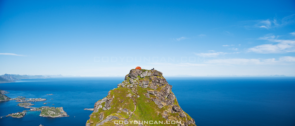
I’ve put together a list of what I think are my best image from each month of 2010.  That’s not to say these are all my best images of the year, as nearly all of them would have been from the Lofoten islands in January.  It’s been a good look at my consistency throughout the year.   There are definitely a few filler images from months where I wasn’t able to shoot much for whatever reason.   I’d say, April, June, and September are the weaker images of the year, Jan and July my favorites.

As a whole, it was an okay year photographically. I think I’ve captured some of my best images ever and had a couple productive trips.  But I’ve also felt a fair amount of frustration in being unable to realize a fair amount of my vision.  I guess I could say it better as: more often than not, I’ve failed to return with the images I wanted.  This is quite normal for landscape photography, but part of the problem is that I don’t want to be shooting landscape photography, I want to be shooting adventures and journeys surrounded by those landscapes.  Hopefully I’m able to find my vision better in 2011 and take my images to the level at which I want them to be…

Lofoten islands winter beach norway

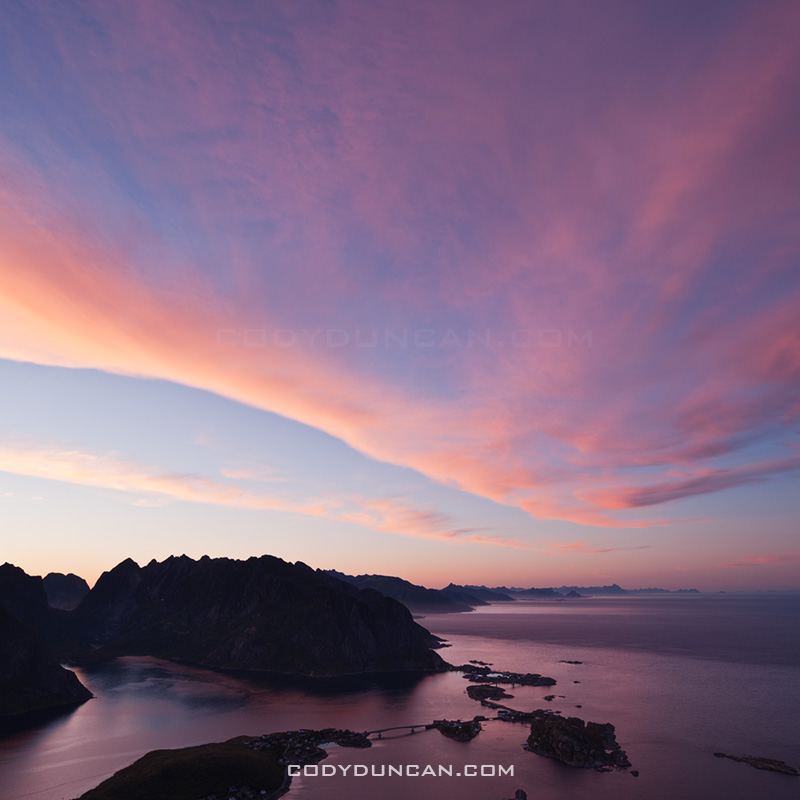
January:  Arctic twilight on Haukland beach, Lofoten islands, Norway

This was a difficult month to pick only a single image from.  The 6 days I spent on the Lofoten islands at the beginning of the month were some of the most inspiring days I’ve ever had.  Jan 6th in particular, my first full day on the islands, was especially memorable and the light was simply amazing.  I was completely frozen after a chilly night sleeping in a wind rocked car.  When dawn arrived in mid morning, all was perfectly calm with a brilliant pink glow.  It was one of those days that I wished I could have been in 100 places at once; there were so many photos to be made, yet only a painfully few 4 hours of light of the arctic winter day.

This image is from Haukland beach and the first place I stopped in the morning.  It was nearly perfectly still, only the gentle waves that seemed more like a lake than ocean disturbed the silence.  While several images from this location could easily be my favourite images, I think this is the best.  For me the single piece of ice helps show the isolation of the frozen beach and lets the cold reach out to the viewer.  I only stopped shooting at this location when I wasn’t able to feel my feet for some 30 and decided I should try and warm up a bit.  My only critique is the otter tracks that pass through the image.

Lofoten islands winter: Click here to view gallery

Devils racetrack death valley

February:  Night on the Devil’s Racetrack, Death Valley national park, California

Another difficult month to choose from, mostly due to a fairly productive trip to Death Valley towards the end of the month.  After having spent the autumn and early winter in Scandinavia and the UK, I was in need for a bit of a change in scenery.  So I headed out to explore some parts of Death Valley national park that I’ve never been to before.

This image is from the Devil’s Racetrack, more commonly know as the location with the moving rocks.  Unfortunately, the above average winter rains had flooded the southern part of the lake where the rocks are, leaving it impassible due to the danger of leaving permanent damage to the fragile area.  Fortunately the northern half of the playa was dry and walkable.  A bit bored, with my planned shooting location off limits, I thought I’d just go lay down in the middle of the lake.  It was quite amazing really, all alone in the middle of nowhere, full moon overhead, cold night temperatures of winter desert, some AM talk station coming out of the radio.  I stayed out there shooting late into the night.

Abandoned walkay in water, Salton Sea, California

March:  Abandoned dock, Salton Sea, California

My last journey to the Salton Sea was in 2005, or was it 2004? Can’t remember at the moment.  Anyhow, in March, before temperatures became unbearably hot for me, I headed down.  I had been to this location on my last trip, so as I arrived in the dark of early morning I thought I knew where I would be.  How I was wrong.  The sea level was now far lower and the shore nowhere near as I remembered.  Anyhow, as I explored a bit, I found this cool old dock just as the first light of the sun was arriving.

Burnt tree in Mojave national preserve, California

April: Charred tree, Mid Hills Campground, Mojave national preserve, California

In 2005, lightning strikes started the Hackberry fire which swept thought the high desert area of the Mojave national preserve.  On the first night of a 4WD trip of the Old Mojave Road, we camped at the Mid Hills campground which was partially burned.  I’d never been to this area, nor heard about the fire, so It was quite interesting to see a charred desert landscape.

Mt whitney tent

May: View from tent towards east face of Mt. Whitney, Sierra Nevada Mountains, California

Nearly five years to the day of my last trip up Mt. Whitney, I found myself looking at the mountain again.  It was sort of a last minute trip, but everything worked out and I made a successful climb of the mountain.  This is the view from my camp at Iceberg lake towards the east face and Mountaineers route of Mt. Whitney.

Brecon Beacons wales

June:  Stormy weather over Black Mountain, Brecon Beacons national park, Wales

Black Mountain is the westernmost range of Brecon Beacons national park.  Just an image from a less-than-sunny day wandering among the mountains.

Part II July – December: CLICK HERE

Lofoten Islands Hikes – Justadtinden

Justadtind lofoten islands

Photo: Justadtinden rises in the distance

Lofoten Islands Mountain Hikes: Justadtinden

Justadtinden (738 meters) is the highest peak on the eastern side of Vestvågøya.  An easy and well worn trail through a scenic mountain landscape makes reaching the summit of Justadtinden a relatively easy hike and a good first introduction to the Lofoten islands.  While the summit itself is rather flat and slightly anticlimactic, the 360º view is still something impressive.  When the sun is out and the winds are calm, I imagine this would be a nice place for a picnic on a summer afternoon.

Photo: Winter view from Stamsundsheia. Justadtinden (738 meters) is flat summit on left, Kangerurtinden (704 meters) on right

Getting There

By Car: From north or south, take the E10 to Leknes.  From Leknes, take the 815 towards Stamsund.  After approximately 4km the road rises to the pass at Hagskaret (Where the large building is).  There are two parking options here on the left side of the road (before the building), one paved, one dirt.

From the parking area, take the dirt road towards the large antenna visible a couple hundred meters to the north.  Keep following the road straight.  After passing the antenna building on the right (don’t turn here), the road will soon end and turn into a hiking trail.  There are several trails that cross back and forth, keep in the general direction of the right (east).

Photo: Mountain landscape near Justadtinden

The Trail
From the start of the trail, the summit of Justadtind is approximately 6km away, with 600 meters of elevation gain.  The first half of the trail gently gains elevation while wandering through low hills and ridges.  The second half of the trail gradually increases in steepness (though still quite a gentle grade) and passes through a section of rocks shortly before the summit.  The rocky outcropping that appears as the highest point in the top.

Photo: View from summit of Justadtinden towards Henningsvaer

Camping

There are numerous suitable places for a tent (mostly dry and mostly flat) along the trail, with access to water generally not too far away.  The summit itself is quite flat and large with plenty of room as well.  Depending on the wind direction, several large rocks could provide some shelter from the weather, but as always, necessary caution should be taking if wishing to camp on an exposed summit.  No water available at the top.

Useful Links

Topo map: Search ‘Justadtinden.’

View from Justadtinden, Vestvagoy, Lofoten islands, Norway

Photo: View from Justadtinden towards Himmeltindan

Lofoten islands winter

Photo: Justadtinden hidden behind Kangerurtinden in winter

Lofoten Islands Hikes – Reinebringen

Reinebringen Lofoten islands norway

Photo: Scenic view over Lofoten islands from summit of Reinebringen

Lofoten islands Hikes: Reinebringen

At a modest 448 meters high, Reinebringen is far from one of the highest peaks on the Lofoten islands.  Yet this is more than made up for by the spectacular view provided from the summit.  This view, combined with a relatively short hike and easy access from Reine means that Reinebringen is one of the most popular hikes on Lofoten.  It should definitely be near the top of ones travel plans while visiting the islands.  And if possible, saved for one of those elusive sunny days.

Directions
• By car:  Drive towards Reine. At the corner of the E10 and the turnoff into Reine is a parking area.  Alternatively, on the Å side of Ramsvikstunnelen are several small pullouts along the E10.

• By Bus: Take the bus to Reine.  You can ask the driver to let you off on the side of the E-10, before heading down into the village.

From Reine: walk west (south) along the E10 in the direction of Å.  Take the paved path along the outside of the tunnel (Ramsvikstunnelen).  Where the path is close to connecting back with the E10 on the far side, look for a small trail emerging from the bushes.  In summer it should be fairly simple to locate.

Reinebringen

The Hike

The trail begins as a somewhat muddy path winding its way upwards through low birch forest.  I managed to keep my feet dry wearing only trail runners, but it took a bit of extra care.  Climbing higher up the mountain, the trees begin to thin and and one will come across several short but wet rock steps to negotiate.  Once clear of the forest the trail gradually steepens and alternates between turf (which can be wet/slippery) and rocky sections.  Finally reaching the ridge, many stop here as the view is already quite stunning.  One can continue to the right up the steep rocks and follow the short trail to the last small peak.  Alternatively, one can follow the trail towards the left which continues high up the ridge.  3-4 hours, depending on fitness level, should be adequate for a round trip.

Reineibringen camping lofoten islands

Camping

There are several places along the ridge where a tent can be pitched.  All are completely exposed, so be aware of conditions and any incoming weather.  No water is available near the top, so be sure to bring enough.

Tent camping on Reinebringen mountain peak, Reine, Lofoten islands, Norway

Useful Links

Topo Map: enter ‘Reinebrinen’ in the search box

Lofoten Turlag

Images