Eggum – Lofoten

Eggum winter lofoten islands

Photo: Boat sheds in winter, Eggum, Lofoten islands, Norway. Jan 2010

In summer, with it’s north facing coastline, Eggum is a popular location for campers hoping to see the midnight sun. The grassy, green fields past the town are often filled with tents and RV’s enjoying the 24 hours of daylight during the Lofoten summer. After the road ends there is also a nice, easy coastal walk which connects to the village of Unstad.

In winter, Eggum is a lonely place. There is no light, and cold northern winds often sweep across the landscape.

Eggum winter lofoten islands

Photo: Empty windswept road, Eggum, Lofoten islands, Norway.  Jan 2010

Winter coastline at Eggum, Lofoten islands, Norway

Photo: Rocky coastline in winter, Eggum, Lofoten islands, Norway.  Jan 2010

Grand Canyon Snow

mather point grand canyon

Photo: Dawn light from Mather Point, Grand Canyon

In mid April I spent a week on the road around the desert southwest, which is mostly a new area for me.  The original plan was to head up to Bishop for a week of bouldering/climbing and hopefully some nice sunny springtime weather.  Though seeing as how I haven’t been climbing much lately, I was slightly hesitant that the Buttermilks would tear my fingers apart on the first day and I’d spend the rest of my time sitting around and getting fat on pullaway bread.  And so, after a quick stop at REI in Northridge I plugged the Grand Canyon into the GPS.  Hmm, it’s far, but not that far, I can get there before dark.  And so I headed east instead of north.

Passing into Arizona the skies got darker.  Eventually rain began to fall, which turned to sleet and then snow.   Arriving at the campground on the south rim by evening, winter had fully arrived.  I knew the Grand Canyon received some snow, especially the north rim, but in April?  I checked the weather forecast outside the campground office: snow on Saturday, storm clearing by Sunday morning.  Cool!  I thought, should get a good sunrise opportunity on Sunday.  So I go to pay for 2 nights at the campground where I receive the news.
“You can only stay for tonight.” the ranger lady says.
“What?  are you full tomorrow or is there too much snow?”  I ask.
“No.  Congress hasn’t passed the federal budget, so the park is closing tomorrow”  I’m told.
“What!  seriously?”  I mumble in disbelief, getting slightly disgruntled that I may have just driven all this way to only see snow and clouds.
“Yup, No budget means we have to shut down.  All other national parks as well”

Bugger.  I scramble across the parking lot and through the falling snow back to my truck.  A rant full of colorful language runs through my head as I drive to my snow covered campsite for the night.  Luckily, while eating noodle soup and listening to fuzzy AM radio from a station too far away to for a clear signal, I hear some emergency budget was passed.  I cross my fingers that things should be normal on Saturday and set my alarm for 5am, just in case the storm clears.

Photo: Camp on Saturday morning

grand canyon snow

Photo: Poor visibility during storm on Saturday morning

hiking bright angel trail grand canyon

Photo: hiking the snowy, muddy Bright Angel trail, Grand Canyon

Bright angel trail grand canyon snow

Photo: Snow covered upper section of Bright Angel trail with view across canyon, Grand Canyon

Saturday arrives with a dull gray and snow still falling, nearly a foot of it now covering the campsite picnic bench.  Driving to the canyon rim over the unplowed roads, the visibility is zero.  I had a bit of fun driving around the snow covered roads and seeing how close I could get to being stuck.   A little before noon the storm began lifting and I wandered a ways down Bright Angel trail.  Lots of poor souls were making the hike out of the canyon, many wearing sandals or other light footwear that would normally be appropriate for the hot and dry canyon.  Now they were trudging through boggy snow which turned the trail into a sloppy, muddy mess.  My trail runners were quickly soaked as well.  Wet feet on day one, welcome to my life…  good thing I had a spare set of shoes.

The last time I was at the Grand Canyon was some 14-15 years ago as a teenager, so I really had no idea where to go or what to see.  I did what’s probably the most obvious thing and waited for sunset at Mather Point.  Clouds to the west blocked the sun before it was very low and any color arrived.  I was actually slightly content with this as the wind was bitterly cold, and my still wet shoes left me daydreaming of a warm dinner and sleeping bag more than a nice sunset.

Woke up early again Sunday and headed back to Mather point, trying not to slip on the ice covered pathways.  While Friday night in the storm was cold, Saturday night’s clear skies dropped the temps to near arctic.  Everything inside my truck was frozen, and I was a bit slow moving.  Some nice light arrived, only witnessed by a brave few of us.  I’ve no idea how rare snow is here, but I’m glad I got to see it, even if it meant a bit of suffering from time to time.

CLICK HERE – To view more photos in my archive

grand canyon snow

Photo: Snow covered south rim of Grand Canyon

mather point sunrise grand canyon

Photo: Sunrise from Mather point, Grand Canyon

Hiking the Besseggen Ridge – Jotunheimen National Park, Norway

Hiking the Besseggen Ridge – Jotunheimen national park, Norway

Lake Gjende viewed from Besseggen ridge, Jotunheimen national park, Norway

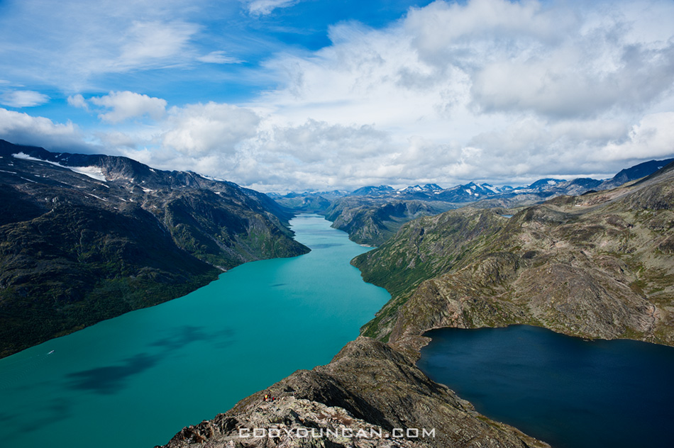
Photo: Lake Gjende and Bessvatnet from Besseggen ridge, Jotunheimen national park, Norway

The Besseggen ridge hike is one of the most popular in Norway, with some 30,000 people making the trek between Gjendesheim and Memurubu each year.  Located in the stunning mountain scenery of Norway’s Jotunheimen national park, the trail roughly follows a ridge on the north side of lake Gjende and provides amazing views of the whole length of the long and colorful lake as it sits surrounded by glaciated mountain peaks.

With a distance of about 8 miles (13 km) and climbing 2,500 feet (759 m) above lake Gjende the hike requires a moderate level of physical fitness.   Expect to take 5-7 hours to complete the hike between Gjendesheim and Memurubu.  The trail is well marked and easy to follow, and due to its popularity, it’s doubtful you’ll be alone – even in bad and rainy weather.

From Gjendesheim, the trail climbs at a moderate gain for several kilometers until finally reaching a high and rocky alpine plateau.  Even if the wind is calm at lake level, it can be cold and windy once up high, be prepared.   The steepest and narrowest section occurs shortly after passing the high point of 5,718 feet (1743 M) – marked with a large cairn.   After this point, the trail then proceeds to quickly drop down to the southern shore of lake Bessvatnet at 4,504 feet (1373m).  Here is were you have one of the best views of Lake Gjende. Lake Bessvatnet represents the approximate half way point and is a good place to sit in the sun (if your lucky) and have a nice lunch.

Continuing from lake Bessvatnet the trail is relatively flat with only moderate climbs/descents until the final short and steep descent to Memurubu and the shores of lake Gjende.

HERE is a good online topo map for all of Norway.  Take a quick look so you can get a bit more comfortable with my descriptions and not mix up Gjende for Gjendebu for Gjendesheim.  Enter either ‘Besseggen’ or ‘Gjende’ in the search box and hit the ‘Kartsøk’ button.  This will get you where you need to look…

besseggen-ridge-norway3

Photo: Ferry leaves Memurubu for Gjendesheim (in far distance)

View of Besseggen ridge and Bessvatnet lake, Jotunheimen national park, Norway

Photo: view east of Besseggen ridge rising above lake Bessvatnet

Day hiking the Besseggen ridge gives one several options on how to go about things and how long of a day is desired.

• Ferry Gjendesheim – Memurubu : Hike Memurubu – Gjendesheim:
A popular way to make the hike is to take the morning ferry from Gjendesheim to Memurubu and make the hike back.  This way has the benefit of not having to meet the ferry schedule for a return trip, thus meaning that one can go as slow or fast as wanted.  One drawback is you will likely be hiking in a crowd of people all arriving with the boat, unless one sits around Memurubu while the crowd continues up the trail.

• Hike Gjendesheim – Memurubu : Ferry Memurubu – Gjendesheim:
This way one can get an early start and have the trail relatively empty.  Though if looking for mountain solitude, I suggest going elsewhere in the park.  The main drawback of this way is that one has to keep schedule to catch the ferry back to Gjendesheim.  Personally, I think the view is more scenic in this direction, and the sun will be at your back during the morning hours.

• Hike Gjendesheim – Memurubu : Hike Memurubu – Gjendesheim:
For a longer day, it’s possible to hike the ridge to Memurubu and back.  Or, to save some tired knees, there is a flat trail that follows the lake, connecting Gjendesheim and Memurubu.

• Ferry Gjendesheim – Gjendebu : Hike Gjendebu – Gjendesheim:
For a long day, take the morning ferry to the end of lake Gjende and Gjendebu and hike back to Gjendesheim.  The section between Gjendebu and Memurubu is relatively uncrowded and provides stunning views of lake Gjende and one approaches Memurubu and also some amazing views of Memurudalen – Memuru valley.

CLICK HERE for ferry schedule
CLICK HERE for ferry prices
CLICK HERE for DNT mountain hut info
CLICK HERE for a topo map of Norway. Search ‘Besseggen’ or ‘Gjende’

lake Gjende ferry

Photo: Ferry and mountain reflections on lake Gjende from Gjendesheim

Overnight trips to the huts:
The lake ferry boat not only carries people, it will also carry luggage.  So, say one is looking to stay overnight at Memurubu or Gjendebu hut, put your luggage on the ferry and hike from Gjendesheim.  When you arrive in Memurubu, your bags will be waiting.  This can also work in reverse, staying your first night in the hut and then hike back to Gjendesheim while your luggage takes the ferry.

Camping:
Wild camping is possible basically everywhere, the only restrictions being the immediate area around the huts.  Water is plentiful and tasty.  On the other hand, finding a flat and dry spot to pitch a tent can sometimes take a bit of searching, but is well worth the effort to sleep with some amazing views out the tent door.

Camping near Gjendesheim.  Walk past the end of the parking area and continue along the lakeside trail for 100m.  Beginning here you you see plenty of places to pitch a tent.  Can get a bit crowded on a nice summer weekend.

Scenic mountain landscape of Jotunheimen national park, Norway

Photo: Alone in the wilderness.  Wild camping in Norway’s Jotunheimen national park

Further into Jotunheimen:
Jutunheimen national park is an amazing place.  I highly recommend making a longer hike through the park, either as a multi-day loop or through hike.  While I enjoy camping in the wild, it’s also possible to carry a light pack and overnight in the well connected network of huts, many of which also serve food.

When to go:
The main summer season in the Norwegian mountains in July and August.  These months will be your best bet for sunny, warm days.

Getting there:
The start or finish of the Besseggen ridge is located at Gjendesheim, on the eastern end of lake Gjende and Jotunheimen national park itself.  Here you’ll find a full service DNT hut, a small (expensive!) shop/cafe, toilets, the ferry boat, and parking area.

By Bus:
Several busses travel to Gjendesheim daily.  The two options are to travel via Fagernes (to/from Oslo) in the south.  To the north the bus travels to Vagamo where one can transfer east to Otta and the train, or continue west through the fjords.

By Train:
There is no direct train link to Jotunheimen national park.  If traveling by train, say from Trondheim in the north, exit at Otta, where you will have to take the bus to Vagamo, then on to Gjendesheim.  The bus/train does not always meet at a convenient time, so be sure to check schedules.

Transportation links:
NSB – Norwegian train company
Nor-Way – Long distance bus routes incl. Olso – Gjendesheim
Ruteinfo – Local and regional bus information
Gjende – Lake Gjende ferry.  Prices and timetable

Other Useful links:
DNT – The Norwegian Trekking Assocaition
Interactive topo map including trails and huts for all of Norway
Norwegian weather

CLICK HERE for more photos of Jotunheimen national park from summer 2010

If there’s anything I seemed to miss, let me know and I’ll try and add it.

View towards Gjendesheim and lake Gjende, Jotunheimen national park, Norway

Photo: Looking towards Gjendesheim on the shore of lake Gjende from near start/finish of Besseggen Ridge trail

Ghost

Lenticular cloud over Sierra Nevada Mountains, California

Photo: Full moon illuminates lenticular cloud over Sierra Nevada Mountains and Alabama hills, California

I didn’t quite realize it’s been a month since my last post.  But truthfully, I haven’t produced much lately that’s very interesting.  And it seems every time I sit down to try and write something, it just ends up as some boring nothingness…

2011 San Felipe Baja 250 Photos

Kendall Norman Kurt Caselli San Felipe Baja 250 2011

Photo: JCR Honda 1x rider Kendall Norman takes a small lead over KTM’s Kurt Caselli into RM 30 pits, 2011, San Felipe Baja 250

Kendall Norman Kurt Caselli San Felipe Baja 250 2011

Photo: JCR Honda 1x rider Kendall Norman haulin’ ass into RM 30 pits. 2011, San Felipe Baja 250

Here’s a few first photos from the 2011 San Felipe Baja 250.  I was at RM 30 for the first bikes coming through.  Headed to the pits at Zoo/Morelia road near RM 90 where I caught the trophy trucks pass by then ending up at the finish for the trophy trucks again.

I was running chase for my Brother and his team on the 209x bike.  They ended up finishing 6th place in the 250cc Sportsman class, a good effort as it was the first Baja race for 3 of the 4 riders.

I’ll hopefully get a gallery up later tonight or tomorrow of more race photos.  More info soon…

Colton Udall San Felipe Baja 250 2011

Photo: JCR Honda 6x rider Colton Udall arriving to RM 30.  2011, San Felipe Baja 250

Jesse James San Felipe Baja 250 2011

Photo: Jesse James trophy truck north of Zoo Road near Rm 90. 2011, San Felipe Baja 250

Finish San Felipe Baja 250 2011

Photo: Crowds await the arrivial of first trophy truck at finish. 2011, San Felipe Baja 250

Jesse Jones San Felipe Baja 250 2011

Photo: Jesse Jones trophy truck finishing fast.  2011, San Felipe Baja 250

Jesse James San Felipe Baja 250 2011

Photo: Jesse James trophy truck finishing. 2011, San Felipe Baja 250

San Felipe Baja 250

San Felipe Baja California

>>UPDATE: March 14, 2011: CLICK HERE for first photos from San Felipe 2011<<

It’s been a few years since I was last in San Felipe for the Baja 250.  I’m driving a truck and trailer full of bikes down for a team and will be helping with the pre-running of the course during the next week.  The race itself is next Saturday the 12th.  San Felipe is one of my favorite towns in Baja, and is a nice and mellow place to hang around for a week.  Should be springtime down there in the desert, so temps wont get to hot.  The race is also overlapping with Carnival celebrations, so it should be a good time…

san felipe baja motorcycle

Death Valley

Winter rain clouds over Badwater and mountains, Death Valley national park, California

Photo: Winter rain falls over Badwater, Death Valley national park, California

The full moon and forecast of rain saw me heading out of town for the deserts of Death Valley national park.  I figured it would also be a good place to contemplate turning 30.  Though the weather didn’t work out quite as planned. Wind gust to 50-60 mph and Sahara like dust storms – basically dust just everywhere.  Have I mentioned I hate dust! – meant it wasn’t the most productive trip.

Most the time was spent sitting in the back of my truck.  I tried to be somewhat productive and start the writing on a project I’ve been working procrastinating on.  Didn’t go so well, just basically stared at a mostly blank page until my laptop battery finally died.  Saved!  I’m glad I never took it upon myself to be a writer of any sort, would’ve been an even more unsuccessful pursuit than photography.

Cooked dinner inside my camper shell as the light faded, reading the instructions on my stove specifically saying not to cook inside.  Are my windows open enough?  What are the symptoms of carbon monoxide poisoning?  Ack, my instant noodle soup’s boiling over onto my bed!  At least I managed to go the whole week without spilling the melt water of my cooler all over my bed, usually a common occurrence. Luck was definitely on my side this time!

This was only my second time to visit the Eureka dunes, located in the isolated northern park of national park and only reached by dirt road.  On my first visit the weather was bad so I didn’t take any photos.  Had slightly better conditions this time, but still not ideal.  The dunes are best photographed at sunset, but by late afternoon clouds would fill the sky before the sun was low enough to the horizon.  At sunrise, mountains to the east block the sun for the first hour after sunrise, so by the time the dunes are lit, the sun is already fairly high in the sky.  Hopefully I’ll make another visit next month.

The blog will still be a bit slow for the next month.  Still trying to catch up on things and get organized with other projects.  I’m going to start posting some sort of ‘series’ of content so that I can try and keep things a bit more regular.  Will probably be something related to the Lofoten Islands, maybe just a single photo some behind the scenes info or whatnot.  I’ll see…

Eureka Dunes Death Valley

Photo: Eureka dunes rise into the desert sky, Death Valley national park, California

Eureka Dunes Death Valley

Photo: Self portrait of view from Eureka dunes, Death Valley national park, California

Luskentyre Beach – Isle of Harris

luskentyre beach isle of harris

Photo: Dawn light over Luskentyre beach, Isle of Harris, Scotland

I went to Luskentyre Beach five times in three days and each and every time I was presented with something different. I think there must be some rule on the Outer Hebrides: If the morning is calm, the evening will be stormy.  If the evening is calm, the morning will stormy.  As this seemed to be the cycle of weather out there.  And with changing weather comes changing light.  Always something new to see in the exact same place as I had been just a few hours before.  Luskentyre is quickly developing into one of my favorite places, though it will most likely be several years now until I get to return again.

luskentyre beach isle of harris

luskentyre beach isle of harris

luskentyre beach isle of harris

luskentyre beach isle of harris

Scottish Western Isles Gallery

Luskentyre beach, Isle of harris, Scotland

Photo: Last light over Luskentyre Beach, Isle of Harris, Outer Hebrides, Scotland

Western Isles, Scotland photography gallery: CLICK HERE

I’ve added about 100 new images to my Western Isles gallery.  The Photos are from my most recent trip from December 30th 2010 – January 8th 2011.  Islands covered are North Uist, South, Uist, Berneray, Isle of Harris, and Isle of Lewis.  I’ve also added a few photo’s from the Isle of Skye, even though it’s not technically part of the Western Isles.

butt of lewis coast

Photo: Rugged coastline at Butt of Lewis, northern most point on the Outer Hebrides, Isle of Lewis, Scotland

Rannoch Moor Winter

Loch Ba ice, Rannoch Moor, Scotland

Photo: Loch Ba frozen in winter, Rannoch Moor, Scotland

Rannoch Moor winter

Photo: Rannoch Moor winter, Scotland