Buchaille Etive Mor

Photo: Buchaille Etive Mor, Glencoe, Scotland. Jan 2011
On the eve of what would be an epic snow storm…
Photo: Buchaille Etive Mor, Glencoe, Scotland. Jan 2011
On the eve of what would be an epic snow storm…

Photo: Lenticular cloud illuminated by full moon over Sierra Nevada mountains, Alabama Hills, California
A 4 image panoramic of the same scene I posted a couple weeks back. Lone Pine peak is the high mountain on the left of the photo, Mount Whitney is about 1/3 from the left, while Mount Williamson is slightly right of center. For a sense of scale, from my position to the summit of Whitney is slightly less than 10,000 ft of elevation gain.

Photo: Isle of Rum as viewed from Elgol, Isle of Skye, Scotland. Jan 2011

Photo: Looking towards viewing platform at Upper Inspiration Point, Bryce Canyon national park, Utah
Originally Bryce Canyon wasn’t on the list of places to visit, but it’s lucky we went as it turned out to be my favorite place on the trip. I’ve seen tons of pics and generally knew what it looked like, but I didn’t know much else. Such as it’s at an elevation of 8,000 – 9,000 ft, and there’s lots of snow. And mostly that it’s just so cool looking in real life, way better than any photo I can take, even when it’s -10˚ C at sunrise.
After leaving the Grand Canyon, to road took us east to Monument Valley, which I’ve never been before. To me the place was sort of anticlimactic. I’m glad I went and saw it, but its not any place that I’m itchin’ to get back to. I don’t really know why. Perhaps it’s because any possible photo has already been taken 10,000 times, or because of the regulations where you’re not supposed to walk around and explore on your own, or just the ‘tourist farm’ feel of the whole place.
After a night at the campground it was time to head back west, roughly towards Zion np. We first stopped at Coral Pink sand dunes state park in southern Utah, which was pretty cool looking, especially as there was snow on the dunes. But the day was young, the sky overcast, and I got a little bored. On the way to the dunes I saw the sign that said Bryce was 74 miles away. Ah, what the hell, I thought to myself. I’m this close already, gas is $1/gal. cheaper in Utah than California, might as well go check it out.

Photo: Hiking among Hoodoo rock formations of the Queens Garden Trail, Bryce Canyon national park, Utah
Arrived in Bryce Canyon around noon, or was it 1pm, as I never changed my watch for Utah time, don’t even know what they use in Arizona. Doesn’t matter anyways for a landscape photographer, the sun doesn’t care what time zone you’re in. The sky was still somewhat hazy so we spent the afternoon getting familiar with the park and trying to decide good sunset/sunrise locations.
The main area of the park, known as the ‘Amphitheater’ is where the most Hoodoo rock formations are. Not to get into a geological essay here, the Hoodoos are left over sea sediment, eroded my water and freeze/thaw cycles over the years. What this creates is something amazingly cool and almost surreal to look at.
Dawn on the second day arrived cold, bitterly cold. Clouds blocked the eastern sky and the day looked like it would remain overcast again. But luckily by around 8:30am or so, the sky began to clear into a brilliant blue with some nice puffy clouds. We took a nice morning hike down the short and muddy Queens Garden trail, which travels down in to the amphitheater and wanders among the hoodoos. It would have been nice to do some other hikes, but a lot of the trails were closed due to the snow or rockfall danger.
In the afternoon, we mostly hung out in the area of Inspiration point. It was one of those days where I know the light is going to get better later on, but I keep taking photos anyhow because it’s so cool looking. But Bryce is definitely a better sunrise location, at least the amphitheater area, as it faces east. In the late afternoon, the sun falls behind the forested slopes on the western side of the amphitheater and the hoodoos are in the shade before the golden hour arrives. Though once the sun has set, I saw some potential for some nice twilight conditions.
The second morning arrived even colder, and windy this time. But the sky was somewhat clear towards the east, so there where some brief moments of golden sunlight on the Hoodoos. Leaving me glad to have stayed another night and thinking about when I can come back again; autumn seems like it would be a nice time…
CLICK HERE: To view more Bryce Canyon images in my photo gallery.

Photo: Tunnel along Queens Garden Trail, Bryce Canyon national park, Utah

Photo: Hiking among Hoodoo rock formations of the Queens Garden Trail, Bryce Canyon national park, Utah

Photo: Hoodoo rock formations of the Amphitheater, Bryce Canyon national park, Utah

Photo: Hoodoos at sunrise from Sunrise Point, Bryce Canyon national park, Utah

Photo: Winter rain falls over Badwater, Death Valley national park, California
The full moon and forecast of rain saw me heading out of town for the deserts of Death Valley national park. I figured it would also be a good place to contemplate turning 30. Though the weather didn’t work out quite as planned. Wind gust to 50-60 mph and Sahara like dust storms – basically dust just everywhere. Have I mentioned I hate dust! – meant it wasn’t the most productive trip.
Most the time was spent sitting in the back of my truck. I tried to be somewhat productive and start the writing on a project I’ve been working procrastinating on. Didn’t go so well, just basically stared at a mostly blank page until my laptop battery finally died. Saved! I’m glad I never took it upon myself to be a writer of any sort, would’ve been an even more unsuccessful pursuit than photography.
Cooked dinner inside my camper shell as the light faded, reading the instructions on my stove specifically saying not to cook inside. Are my windows open enough? What are the symptoms of carbon monoxide poisoning? Ack, my instant noodle soup’s boiling over onto my bed! At least I managed to go the whole week without spilling the melt water of my cooler all over my bed, usually a common occurrence. Luck was definitely on my side this time!
This was only my second time to visit the Eureka dunes, located in the isolated northern park of national park and only reached by dirt road. On my first visit the weather was bad so I didn’t take any photos. Had slightly better conditions this time, but still not ideal. The dunes are best photographed at sunset, but by late afternoon clouds would fill the sky before the sun was low enough to the horizon. At sunrise, mountains to the east block the sun for the first hour after sunrise, so by the time the dunes are lit, the sun is already fairly high in the sky. Hopefully I’ll make another visit next month.
The blog will still be a bit slow for the next month. Still trying to catch up on things and get organized with other projects. I’m going to start posting some sort of ‘series’ of content so that I can try and keep things a bit more regular. Will probably be something related to the Lofoten Islands, maybe just a single photo some behind the scenes info or whatnot. I’ll see…

Photo: Eureka dunes rise into the desert sky, Death Valley national park, California

Photo: Self portrait of view from Eureka dunes, Death Valley national park, California

Photo: Loch Seaforth, Isle of Lewis, Outer Hebrides, Scotland
…Continuing on from my last post: Best Photos of 2010 Part I: January – June. Here are what I feel my best photo’s from the second half of the year are. The peak of this was my July-August trip to Norway’s Lofoten islands and Jotunheimen national park. Otherwise, a week in Scotland at the end of October was really the only other productive period of photography for me.

July: Summer twilight over Vestfjorden, Stamsund, Lofoten islands, Norway
The second appearance from the Lofoten islands on this list. While the islands are more commonly pictured as jagged mountains rising from the sea, I feel this image helps portray some other aspects of islands: the sea, the light, the silence. Only towards the end of July does the summer sun leave the sky, yet the night still remains a few weeks away. This leaves an ever lengthening period of twilight as the sun travels further below the horizon. It is during this time when the magical light of the north occurs.
This images was from a calm night, just a short walk out to the coast from the wonderful hostel at Stamsund. I’ve stood in this exact same spot a dozen times, and walked away with a dozen different photos. If I’m lucky, I’ll return again and again until I’m an old man.
Click here to view the entire photo gallery from my Lofoten Islands summer trip.

August: Memurudalen and Muru river, Jotunheimen national park, Norway
This was the view only a short walk from my tent in Norway’s Jotunheimen national park. The weather was good this day, so I stopped here hoping this view would provide something spectacular for sunset. Increasing clouds throughout the day led to a dance of shadows across the land. While the sunset I was hoping for never arrived, I feel this image is an adequate representation of the brilliance of this location. Another place that I’ll have to return to in the future.
Click here to view the rest of my images from Jotunheimen national park.
![]()
September: Black mountain, Brecon Beacons national park, Wales
I wont lie, this is more of a filler photo from an unproductive month. It was a nice autumn day out hiking the the Black Mountain, but that’s about it.

October: Callanish standing stones, Isle of Lewis, Scotland
In late October I found myself out on the Scotland’s Western Isles. I had originally intended to travel here last year, but as normal, plans changed. I got lucky when I arrived at the Callanish standing stones in the late afternoon with clear skies and calm wind, about as good of conditions as can be hoped for out there. This photo is just a simple silhouette, yet for some reason it jumps out at me.
Click here to view photos from my Western Isles trip.
![]()
November: Pen Y Fan and Corn Du, Brecon Beacons national park, Wales
I was a bit torn as to what to add here as late November brought a deep freeze to the UK, but I thought this image of the last day of autumn (before the snow) just had some magical light. Typical Welsh weather of clouds, sun and shadows while hiking around Pen Y Fan in the central Brecon Beacons mountains.

December: Winter ice covers Llangorse lake, Brecon Beacons national park, Wales
Llangorse is the only sizeable lake in the nearby area. Despite this, the beginning of December was the first time I’ve ever been there. And that is mostly because the roads have been too bad to go anywhere else. For some reason I became slightly obsessed with getting a proper frozen lake image. On my first visit I fell through some ice and had to leave early before any decent light. With my second time I was greeted with impenetrable fog. Finally on my third visit I had some clear skies, though the light is nothing special. The surface of the lake is a bit messier than I would prefer, but at least the broken pieces of ice add some interesting shapes to the image.
I’ve put together a list of what I think are my best image from each month of 2010. That’s not to say these are all my best images of the year, as nearly all of them would have been from the Lofoten islands in January. It’s been a good look at my consistency throughout the year. There are definitely a few filler images from months where I wasn’t able to shoot much for whatever reason. I’d say, April, June, and September are the weaker images of the year, Jan and July my favorites.
As a whole, it was an okay year photographically. I think I’ve captured some of my best images ever and had a couple productive trips. But I’ve also felt a fair amount of frustration in being unable to realize a fair amount of my vision. I guess I could say it better as: more often than not, I’ve failed to return with the images I wanted. This is quite normal for landscape photography, but part of the problem is that I don’t want to be shooting landscape photography, I want to be shooting adventures and journeys surrounded by those landscapes. Hopefully I’m able to find my vision better in 2011 and take my images to the level at which I want them to be…

January: Arctic twilight on Haukland beach, Lofoten islands, Norway
This was a difficult month to pick only a single image from. The 6 days I spent on the Lofoten islands at the beginning of the month were some of the most inspiring days I’ve ever had. Jan 6th in particular, my first full day on the islands, was especially memorable and the light was simply amazing. I was completely frozen after a chilly night sleeping in a wind rocked car. When dawn arrived in mid morning, all was perfectly calm with a brilliant pink glow. It was one of those days that I wished I could have been in 100 places at once; there were so many photos to be made, yet only a painfully few 4 hours of light of the arctic winter day.
This image is from Haukland beach and the first place I stopped in the morning. It was nearly perfectly still, only the gentle waves that seemed more like a lake than ocean disturbed the silence. While several images from this location could easily be my favourite images, I think this is the best. For me the single piece of ice helps show the isolation of the frozen beach and lets the cold reach out to the viewer. I only stopped shooting at this location when I wasn’t able to feel my feet for some 30 and decided I should try and warm up a bit. My only critique is the otter tracks that pass through the image.
Lofoten islands winter: Click here to view gallery

February: Night on the Devil’s Racetrack, Death Valley national park, California
Another difficult month to choose from, mostly due to a fairly productive trip to Death Valley towards the end of the month. After having spent the autumn and early winter in Scandinavia and the UK, I was in need for a bit of a change in scenery. So I headed out to explore some parts of Death Valley national park that I’ve never been to before.
This image is from the Devil’s Racetrack, more commonly know as the location with the moving rocks. Unfortunately, the above average winter rains had flooded the southern part of the lake where the rocks are, leaving it impassible due to the danger of leaving permanent damage to the fragile area. Fortunately the northern half of the playa was dry and walkable. A bit bored, with my planned shooting location off limits, I thought I’d just go lay down in the middle of the lake. It was quite amazing really, all alone in the middle of nowhere, full moon overhead, cold night temperatures of winter desert, some AM talk station coming out of the radio. I stayed out there shooting late into the night.

March: Abandoned dock, Salton Sea, California
My last journey to the Salton Sea was in 2005, or was it 2004? Can’t remember at the moment. Anyhow, in March, before temperatures became unbearably hot for me, I headed down. I had been to this location on my last trip, so as I arrived in the dark of early morning I thought I knew where I would be. How I was wrong. The sea level was now far lower and the shore nowhere near as I remembered. Anyhow, as I explored a bit, I found this cool old dock just as the first light of the sun was arriving.

April: Charred tree, Mid Hills Campground, Mojave national preserve, California
In 2005, lightning strikes started the Hackberry fire which swept thought the high desert area of the Mojave national preserve. On the first night of a 4WD trip of the Old Mojave Road, we camped at the Mid Hills campground which was partially burned. I’d never been to this area, nor heard about the fire, so It was quite interesting to see a charred desert landscape.

May: View from tent towards east face of Mt. Whitney, Sierra Nevada Mountains, California
Nearly five years to the day of my last trip up Mt. Whitney, I found myself looking at the mountain again. It was sort of a last minute trip, but everything worked out and I made a successful climb of the mountain. This is the view from my camp at Iceberg lake towards the east face and Mountaineers route of Mt. Whitney.
![]()
June: Stormy weather over Black Mountain, Brecon Beacons national park, Wales
Black Mountain is the westernmost range of Brecon Beacons national park. Just an image from a less-than-sunny day wandering among the mountains.

Photo: Fires of the Ewige Anbetung light festival above Pottenstein, Franconia, Germany. Jan 6, 2009
As the light of a cold January day fades into night a thousand fires are lit, illuminating the hillsides surrounding the town of Pottenstein. The fires are part of the Catholic celebration of the Ewige Anbetung (Eternal Adoration) which occurs in Pottenstein on the 6th of January every year. The light and fire festival attracts thousands of visitors who line the hillsides and fill the streets, braving the cold and watching a display that can only described as spectacular. To see the Lichterfest in person would be a memorable moment of any winter holiday in Germany.

Photo: Burg Pottenstein and fires of Ewige Anbetung Lichterfest, Pottenstein, Franconia, Germany. Jan 6, 2009
When:
Thursday, January 6th 2011
The festival begins around 5pm as the sky gets dark. Be sure to arrive early to find parking. The fires will burn for a couple hours into the night.
Where:
Pottenstein is located in wonderful countryside of the Franconian Switzerland (Fränkische Schweiz) region of Upper Franconia (Oberfranken), Northern Bavaria. By car, Pottenstein is approximately 1 hour north of Nuremberg or 30 minutes south of Bayreuth; 10 km west from the A9 autobahn. Postcode 91278.

There are also several other light festivals of the Ewige Anbetung celebrated elsewhere in the Fränkische Schweiz region in the weeks preceding the festival in Pottenstein. CLICK HERE for more information and dates (in German)
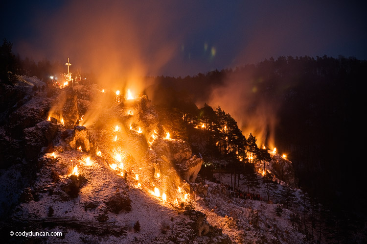
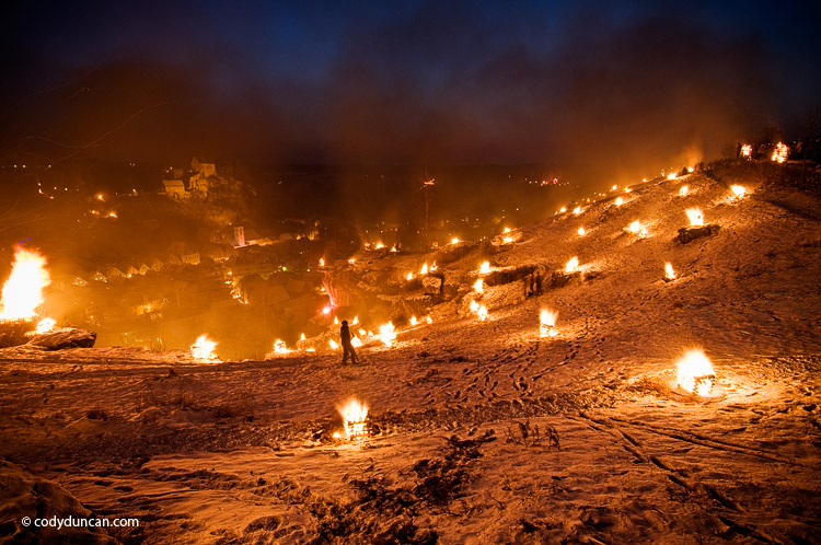
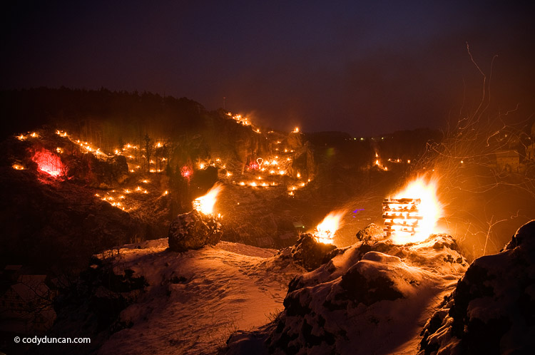
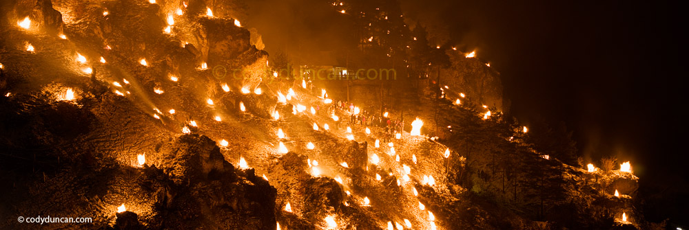

Photo: Winter ice on Llangorse lake, Brecon Beacons national park, Wales. December 2010
With clear weather forecasted for today, I looked out the window at 5am to see a nice starry sky. A little bit more sleep and then it was time to head back to Llangorse lake for another attempt at sunrise. Arriving at the lake in the pre-dawn darkness, the skies were clear, no fog today! Gradually as the sun rose some clouds arrived in the east blocking most of the first light that should have lit up Pen Y Fan off in the distance. Oh well, guess another trip will be scheduled for sometime in the next week.